Totness Recreation Park facts for kids
Quick facts for kids Totness Recreation ParkSouth Australia |
|
|---|---|
|
IUCN Category III (Natural Monument)
|
|

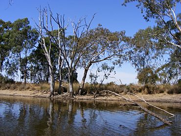
Railway dam in Totness Recreation Park
|
|
| Nearest town or city | Mount Barker |
| Established | 15 January 1970 |
| Area | 41 hectares (101 acres) |
| Visitation | "quite low"' (in 2007) |
| Managing authorities | Department for Environment and Water |
| See also | Protected areas of South Australia |
Totness Recreation Park is a special protected area in South Australia. It's located near the towns of Mount Barker and Totness. This park covers about 41 hectares (101 acres) of land.
A big road called the South Eastern Freeway actually divides the park into two parts. A large dam is also a key feature here. The park was first set up in 1970. It became a recreation park in 1972. It's a unique place because it's the only park in its area managed by the Department of Environment and Water that is just for recreation.
Even though some parts of the park have lots of unwanted plants like gorse and blackberry, it also has important native plants. These include messmate stringybark and manna gum woodlands. These trees are now quite rare in the Mount Lofty Ranges area.
Contents
Exploring Totness Recreation Park
Totness Recreation Park is about 25 kilometers (16 miles) south-east of Adelaide city centre. It's also just 2.5 kilometers (1.6 miles) north-west of Mount Barker.
The park is 41 hectares (101 acres) in size. The South Eastern Freeway splits it into two sections. About 9 hectares (22 acres) are north of the freeway. The larger part, about 32 hectares (79 acres), is south of it. You can get between the two parts through a concrete storm water pipe. This pipe is 1.5 meters (5 feet) high and 100 meters (330 feet) long.
The park is surrounded by farms used for grazing animals. A very important feature is an old railway dam in the northern part. Most of the park's water drains into this dam. Any extra water from the dam flows into the Mount Barker Creek. This creek then joins the Bremer River.
You can find walking trails all over the park. There are also dirt tracks for vehicles along the edges. A wooden boardwalk was built in 2001 in the northern section. It helps people walk through muddy areas. Other than this boardwalk, there are no buildings or special visitor signs.
The park sits on the eastern side of a hill. This hill divides the water flow for the Onkaparinga and Bremer rivers. The rocks in the park are mainly Quartzite and sandstone. The soil is not very fertile and doesn't hold much water. This makes it hard for plant roots to grow deep. However, in the bottoms of valleys, the soil can be deeper. These areas can get very muddy in winter.
Totness Recreation Park is known as an IUCN Category III protected area. This means it's important for protecting natural features.
Managing and Visiting the Park
The park is on the traditional lands of the Peramangk Aboriginal Tribe. However, no old Aboriginal items have been found here yet. The park is looked after by the Department of Environment and Water (DEW). They work with a volunteer group called the Friends of Totness.
Totness Recreation Park is part of a bigger area called Yurrebilla. This area includes the Greater Mount Lofty Parklands. In the Mount Barker District, Totness is the only DEW park just for public recreation. Most of the park is a "Conservation Zone." This means you can't ride bikes, swim, camp, drive cars, or ride horses. Dogs are also not allowed in most areas. However, dogs on leads are allowed in the northern section. Sometimes, visitors don't always follow the rules about swimming, dogs, and horse riding.
The weather here is like a Mediterranean climate. This means cool, wet winters and warm, dry summers. On average, the park gets about 780 millimeters (31 inches) of rain each year. Most of this rain falls between May and August.
Park History
The land that is now Totness Recreation Park first became a protected area on January 15, 1970. It was called the Totness National Parks Reserve. Later, on April 27, 1972, it was renamed Totness Recreation Park. This change happened under a new law called the National Parks and Wildlife Act 1972.
In 1980, the park was added to a list called the former Register of the National Estate. This list recognized important heritage places.
On February 16, 1983, a big event happened. The part of the park south of the freeway was completely burned by the Ash Wednesday bushfires. The freeway stopped the fire from spreading to the northern section. Because of this, the two parts of the park now look different. The southern part has new, smaller trees growing back. The northern part has older, more mature trees.
How the Land Was Used Before
Most of the park acts like a watershed for the large dam in the northern section. This dam was built in 1884. It was used by the South Australian Railways to fill up steam trains with water. Until 1944, water was piped about 2.4 kilometers (1.5 miles) to the Mount Barker Railway Station. It was mainly used for trains going to Victor Harbour.
The dam also provided water for the town of Mount Barker. But in 1955, the town started getting water from the River Murray. This water came through the Mannum–Adelaide pipeline.
The southern part of the park was first given to John Dunne in 1853. He was an important person in Mount Barker's early days. The area around the dam was rented by the District Council of Mount Barker. They used it to collect wood and bark. The bark from golden wattle trees was used at the Mount Barker tannery. Messmate stringybark trees were cut for firewood. Before 1970, the park's land belonged to the South Australian Railways and the state government's Department of Transport.
Plants and Animals of Totness Park
Park Plants (Flora)
When the park was first created, the northern part had a lot of gorse, dog rose, and blackberry. The southern part was regrowing after trees had been cut down. Gorse was so common that people sometimes called the park "Gorse Park."
Introduced plants (weeds) were a big problem and still grow in some areas. For a long time, park managers focused on controlling gorse. Each year, undergrowth is cut to help prevent bushfires.
More than 180 native plant species have been found here. There are also 46 types of weed species. Gorse, blackberry, and bridal creeper are listed as "Weeds of National Significance." This means they are some of South Australia's most harmful weeds to the environment. Blackberry, dog rose, and African daisy mostly grow along water lines and near the dam. Montpellier broom is another common weed.
In the early 2000s, two new weed types were found: pussy-tails and African orchids. A serious plant disease called cinnamon fungus is also a concern. It damages plants in the Adelaide Hills. It hasn't been officially found in the park yet, but experts think it might be in the southern section.
The park has important native plant communities. These are special because they are rare in the Adelaide Hills today. They include messmate stringybark woodland and open forest. There is also manna gum woodland.
Park Animals (Fauna)
Thirty-six different native bird species have been seen in the park. The large eucalyptus trees in the north are great places for birds to build nests. You might see Adelaide rosellas and kookaburras here.
Some of the birds found are very important for conservation. This means they are rare or at risk. These include the yellow-tailed black cockatoo, scarlet robin, and Bassian thrush.
The dam and its surroundings are home to ducks and other water-birds. You might spot white-faced herons, cormorants, and sometimes even Australian pelicans. In 1980, some small native fish called big-headed gudgeons were put into the dam. This was probably to feed the redfin perch, which are caught for fun fishing.
Small groups of western grey kangaroos rest in the park during the day. They then go to nearby fields to eat grass. Other animals known to live in the park include common ringtail possums, short-beaked echidnas, and various types of bats. Koalas are also found here, even though they are not originally from the Mount Lofty Ranges.
Many introduced or wild animals are also seen. These include European rabbits, brown hares, house mice, black rats, red foxes, and deer. Domestic cats and dogs that have strayed from home have also been recorded. Many introduced bird species are also present. As of 2006, rabbits are the biggest pest problem in the park. They damage the soil and stop native plants from growing back.
 | James Van Der Zee |
 | Alma Thomas |
 | Ellis Wilson |
 | Margaret Taylor-Burroughs |


