
Travnik facts for kids
Quick facts for kids
Travnik
Травник
|
||
|---|---|---|
|
Town and municipality
|
||
.jpg)
Travnik
|
||
|
||

Location of Travnik Municipality within Bosnia and Herzegovina.
|
||

Travnik
Location in Bosnia and Herzegovina
|
||
| Country | ||
| Entity | Federation of Bosnia and Herzegovina | |
| Canton | ||
| Area | ||
| • Town and municipality | 529 km2 (204 sq mi) | |
| Elevation | 514 m (1,686 ft) | |
| Population | ||
| • Density | 101.10/km2 (261.8/sq mi) | |
| • Urban | 15,344 | |
| • Municipality | 53,482 | |
| Time zone | UTC+1 (CET) | |
| • Summer (DST) | UTC+2 (CEST) | |
| Postal code |
72270
|
|
| Area code(s) | +387 30 | |

Travnik (Cyrillic: Травник) is a town and a local government area in Bosnia and Herzegovina. It is the main city of the Central Bosnia Canton, which is part of the Federation of Bosnia and Herzegovina. Travnik is located in the middle of Bosnia and Herzegovina, about 90 kilometers (56 miles) west of Sarajevo. In 2013, the town had about 15,344 people. The whole local government area had 53,482 people.
For a long time, from 1699 to 1850, Travnik was the capital city for the governors of Bosnia. Because of this, it has a rich history and many old buildings from that time.
Contents
Geography of Travnik
Travnik is found near the center of Bosnia and Herzegovina. The Lašva river flows through the town from west to east. It later joins the Bosna River. Travnik is built in the wide Lašva valley. This valley connects the Bosna river valley in the east with the Vrbas river valley in the west.
Travnik is about 514 meters (1,686 feet) above sea level. The area is known for its mountains, especially Vilenica and Vlašić. Vlašić is one of the tallest mountains in the country, reaching about 1,933 meters (6,342 feet) high.
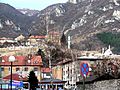
A large karst spring called Plava Voda (Blue Water) starts under Vlašić mountain. It is located right below Travnik Castle, in the heart of Travnik's Old Town.
Travnik's Climate
Travnik has a continental climate. This means it has warm summers and cold, snowy winters. The average temperature in July is about 19.0°C (66.2°F). In January, the average temperature is around -1.0°C (30.2°F). It snows in Travnik every year.
| Climate data for Travnik | |||||||||||||
|---|---|---|---|---|---|---|---|---|---|---|---|---|---|
| Month | Jan | Feb | Mar | Apr | May | Jun | Jul | Aug | Sep | Oct | Nov | Dec | Year |
| Daily mean °C (°F) | −1.0 (30.2) |
0.6 (33.1) |
3.9 (39.0) |
8.6 (47.5) |
13.3 (55.9) |
17.0 (62.6) |
19.0 (66.2) |
18.9 (66.0) |
14.3 (57.7) |
9.6 (49.3) |
4.8 (40.6) |
−0.2 (31.6) |
9.1 (48.3) |
| Average precipitation mm (inches) | 63.9 (2.52) |
68.9 (2.71) |
59.3 (2.33) |
76.8 (3.02) |
94.9 (3.74) |
91.2 (3.59) |
87.5 (3.44) |
69.6 (2.74) |
106.8 (4.20) |
94.4 (3.72) |
111.4 (4.39) |
106.2 (4.18) |
1,030.9 (40.58) |
| Average rainy days | 6 | 7 | 11 | 16 | 15 | 13 | 10 | 11 | 10 | 12 | 10 | 8 | 129 |
| Average snowy days | 10 | 9 | 7 | 3 | 0 | 0 | 0 | 0 | 0 | 1 | 4 | 9 | 43 |
| Average dew point °C (°F) | −4 (25) |
−2 (28) |
0 (32) |
2 (36) |
7 (45) |
11 (52) |
12 (54) |
11 (52) |
10 (50) |
6 (43) |
0 (32) |
−2 (28) |
4 (40) |
| Source 1: Climate Charts(temperatures-precipitation 1993-2022) | |||||||||||||
| Source 2: unipage.net(Rain and snow days-dew point) | |||||||||||||
History of Travnik
People have lived in the Travnik area since the Bronze Age. But the real history of Travnik starts around the first few centuries AD. During this time, the Romans had settlements here. They left behind graves, forts, and other building remains. Roman coins and plaques have been found in the town.
In the Middle Ages, the Travnik area was a province of the medieval Bosnian Kingdom. The town itself was one of several fortified places. Its fortress, called Kaštel, is now the old town area. The Ottomans first mentioned Travnik when they were conquering nearby Jajce.
After the Ottomans took over Bosnia in the 15th century, many local people became Muslims. The town quickly grew. Authorities built mosques, markets, and other important buildings. In 1699, when Sarajevo was burned, Travnik became the capital of the Ottoman province of Bosnia. Important officials called viziers lived here. The town became a key center for the empire's western border. Consulates from France and Austria-Hungary were set up here.
When Austria took control, Travnik saw new Western ideas and industries. However, its importance decreased. Other cities like Banja Luka and Sarajevo grew much faster. Travnik changed so little that by 1991, it only had about 30,000 people.
In September 1903, a large fire started by a train spark destroyed most of the town. Only a few small areas and the fortress were saved. It took several years to clean up and rebuild.
From 1922 to 1929, Travnik was the capital of the Travnik Oblast. Later, from 1929 to 1941, it was part of the Drina Banovina in the Kingdom of Yugoslavia.
During the Bosnian War in the early 1990s, Travnik mostly avoided damage from Serbian forces. It even took in people seeking safety from nearby Jajce. However, there was fighting between local Bosniak and Croat groups before a peace agreement was signed in 1994. After the war, Travnik became the capital of the Central Bosnia Canton.

How Travnik is Governed

Travnik is the main administrative center for the Municipality of Travnik. This area includes the town of Travnik and 89 other smaller villages. Travnik is also the capital of the Central Bosnia Canton. This is one of the ten Cantons in Bosnia. The local government has different offices. These offices manage things like building new areas and helping people who have had to move from their homes.
Travnik's Economy
The economy in the Travnik area faced big challenges during the war in the early 1990s. Before the war, in 1981, Travnik's economy was doing quite well. Today, much of the region focuses on farming and raising animals. In the town, there are factories that make different products, from matches to furniture. Food processing is also a strong industry, especially companies that work with meat and milk.
Tourism in Travnik
.jpg)
Like many towns in Bosnia, Travnik's tourism is based on its history and natural beauty. Nearby Mount Vlašić is one of the highest mountains in Bosnia and Herzegovina. It is a great place for skiing, hiking, and sledding. While tourism is not huge for the town itself, Mount Vlašić is a major tourist attraction.
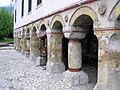
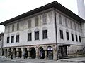
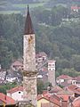
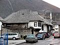
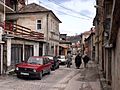
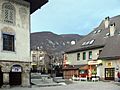
Many buildings from the Ottoman era are still in excellent condition. These include mosques, traditional homes, two clock towers (Travnik is the only town in Bosnia with two!), and fountains. The old town dates back to the early 15th century. This makes it one of the most popular historical sites from that time.

People of Travnik
In 2013, the town of Travnik had 15,344 people. Most of the people living in Travnik are Bosniaks, followed by Croats and Serbs. The wider Travnik municipality had 53,482 people in 2013.
Culture in Travnik


Travnik has a rich culture, much of it from when it was an important government center during the Ottoman Empire. The town has a popular old town area that dates back to the 15th century. You can find many mosques and churches here. There are also tombs of important historical figures and beautiful examples of Ottoman buildings. The town museum, opened in 1950, is a great place to learn about the region's history.
Ivo Andrić, a famous writer from Travnik, wrote a well-known book called Bosnian Chronicle (or Travnik Chronicle). This book describes life in Travnik during the Napoleonic Wars.
The Bosnian Tornjak is one of Bosnia's two main dog breeds and a national symbol. This breed first came from the area around the Vlašić mountain.
Sports in Travnik
The local football team is NK Travnik. It was started in 1922.
Getting Around Travnik

Train Travel
Travnik, like the Central Bosnia Canton, does not have train connections today. In the past, there was a narrow-gauge railway that served the city, but it is no longer used.
Famous People from Travnik
- Ivo Andrić, a writer who won the Nobel Prize in Literature in 1961.
- Miroslav Ćiro Blažević, a professional football manager and player.
- Muharem Bazdulj, a Bosnian novelist and journalist.
- Nura Bazdulj-Hubijar, a Bosnian poet and novelist.
- Brothers Josip and Zlatko Pejaković, artists, actors, and musicians.
- Davor Džalto, an artist, art historian, theologian, and philosopher.
- Nikša Bratoš, a composer and music arranger.
- Oliver Frljić, a theatre director.
- Vjekoslav Kramer, a chef.
- Sena Jurinac, an opera singer.
- Solomon Gaon, a Sephardic Rabbi.
- Mirosław Ferić, a fighter pilot.
- Nikola Mandić, a politician.
- Zlata Bartl, a scientist who created Vegeta.
- Frano Zubić, a Bosnian Franciscan.
- Larisa Cerić, a judoka and European Championship silver medalist.
- Mladen Solomun, a DJ and music producer.
- Vildana Selimbegović, a journalist and editor of Oslobođenje.
Travnik's Sister Cities

Travnik is connected with these sister cities:
Gallery
-
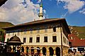
Sulejmanija Mosque
-
Sulejmanija Mosque
-
Sulejmanija Mosque
-
Sulejmanija Mosque
-
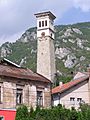
Sahat Kula, Clock Tower
-
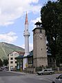
Another Clock Tower
-
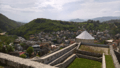
View from Travnik Castle
-
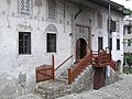
Birthplace (home) of Ivo Andrić
-
Poturmahala
-
Old Town
-
-
Entry to Travnik from the eastern side


See also
 In Spanish: Travnik para niños
