
İzmit facts for kids
Quick facts for kids
İzmit
|
||
|---|---|---|
|
Settlement
|
||
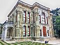
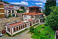
_01.jpg) _01.jpg) .jpg) .jpg) _01_(cropped).jpg)  .jpg) Clockwise from top: İzmit Clock Tower, SEKA Park, SEKA Paper Museum, Kocaeli Museum, Gayret Museum Ship, Downtown İzmit, Mansion of Selim Sirri Pasha
|
||
|
||

Map showing İzmit District in Kocaeli Province
|
||

İzmit
Location in Turkey

İzmit
Location in Marmara
|
||
| Country | Turkey | |
| Province | Kocaeli | |
| Area | 480 km2 (190 sq mi) | |
| Population
(2022)
|
376,056 | |
| • Density | 783/km2 (2,029/sq mi) | |
| Time zone | TRT (UTC+3) | |
| Area code | 0262 | |

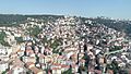
İzmit is a city in Turkey. It is the main city and capital of Kocaeli Province. İzmit is located on the Gulf of İzmit, which is part of the Sea of Marmara. It is about 100 kilometers (62 miles) east of Istanbul.
In ancient times, İzmit was known as Nicomedia. It was a very important city in the Roman Empire. Between 286 and 324 AD, it was one of the Roman Empire's capital cities. This was during a time called the Tetrarchy, started by Emperor Diocletian. Later, after Emperor Constantine the Great won a big battle in 324 AD, Nicomedia became his temporary capital. He then built a new capital city nearby, which he called New Rome (later known as Constantinople, and today as Istanbul). Constantine died near Nicomedia in 337 AD. During the Ottoman Empire, İzmit was also an important regional capital.
Contents
- What's in a Name?
- Where is İzmit Located?
- A Look Back at İzmit's History
- What to See in İzmit
- İzmit's Economy and Industry
- Neighborhoods of İzmit
- Getting Around İzmit
- İzmit's Population Over Time
- Learning in İzmit
- İzmit's Weather
- Images for kids
- Sister Cities
- Sports in İzmit
- Famous People from İzmit
- See also
What's in a Name?
The name "İzmit" comes from the ancient Greek name of the city, Nicomedia. It's similar to how the name "Istanbul" came to be. Before Turkey officially started using the Latin alphabet, people sometimes spelled İzmit as Ismid or Iskimid.
Where is İzmit Located?
İzmit is located between 40°-41° North and 29°-31° East. To the south, it has the Gulf of İzmit. To the west, you'll find Istanbul and the Sea of Marmara. The Black Sea is to the north, and Sakarya Province is to the east.
The city is mostly built on hills because the flat land near the sea is quite small. This means İzmit has two main parts. The city center is on the flat plains near the sea. Important roads and railways pass through this area. The second part of the city is built on the hills. Here, you can find many old houses from the Ottoman Empire period.
A Look Back at İzmit's History

.jpg)
Long ago, around 712 BC, the city was called Astacus or Olbia. After it was destroyed, it was rebuilt in 264 BC by Nicomedes I of Bithynia. He named it Nicomedia. This city became one of the most important places in northwestern Asia Minor.
A famous general from Ancient Carthage named Hannibal spent his last years in Nicomedia. He died nearby between 183 and 181 BC. The historian Arrian was also born in Nicomedia.
In 286 AD, the Roman Emperor Diocletian made Nicomedia the eastern capital of the Roman Empire. It stayed a capital until 324 AD, when Licinius was defeated by Constantine the Great. Constantine lived in Nicomedia as his temporary capital for six years. In 330 AD, he declared the nearby city of Byzantium as the new capital, calling it Nova Roma. This city later became known as Constantinople (modern Istanbul). Constantine passed away near Nicomedia on May 22, 337 AD. Even after Constantinople was founded, Nicomedia remained important because many roads from Asia led to the new capital through it.
İzmit was under Byzantine rule until the late 11th century. Then, it was captured by the Seljuk Turks. However, the city soon returned to Byzantine control after the First Crusade. After Constantinople was attacked in 1204 during the Fourth Crusade, Nicomedia became part of the Latin Empire. The Byzantines took it back around 1235. The city remained Byzantine until the Ottoman Turks conquered it in 1337.

During the Turkish War of Independence, İzmit was occupied by the United Kingdom on July 6, 1920. The British then handed it over to Greece on October 27, 1920. Turkish forces took İzmit back on June 28, 1921.
A very strong earthquake, measuring 7.6 on the Mercalli intensity, hit the region on August 17, 1999. This earthquake caused a lot of damage. More than 17,000 people died, and half a million people lost their homes. It took several years for the city to recover from this disaster.
What to See in İzmit

İzmit has many interesting places to visit, both in the city center and nearby. These include:
- Remains of ancient buildings like the Acropolis, Agora, Amphitheater, and Nymphaeum.
- The Demeter Temple.
- Old Roman city walls, aqueducts (water channels), and cisterns (water storage).
- Parts of the Temple of Augustus.
- Parts of the Palace and Arsenal of Diocletian.
- The Byzantine fortress.
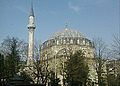
- Orhan Gazi Mosque, built in 1333.
- The 14th-century Süleyman Paşa Hamam (bathhouse).
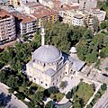
- The 16th-century Imaret Mosque and Pertev Paşa Mosque (1580), designed by the famous Ottoman architect Mimar Sinan.
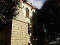
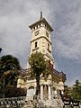
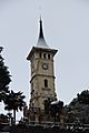
- The İzmit Clock Tower, built in 1901.
- The Kocaeli Museum, where you can learn about the area's history.
- The SEKA Paper Museum, which tells the story of paper making.
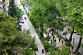
- Fethiye Street, a lively street in the city.
İzmit's Economy and Industry


.jpg)
İzmit has always been an important port city. In the past, wood from the forests around İzmit was used to make charcoal. In the 1920s, the area was also known for making linen fabric, mostly by hand. İzmit also had factories that made uniforms for the Turkish Army and Navy. People also made carpets and embroidery here.
Today, İzmit is a major industrial center. It has a large oil refinery and big factories that make paper and cement. Ford Motor Company has a factory here that makes vans like the Ford Transit. İzmit became the only place in Europe to produce Ford Transit vans after a plant in England closed in 2013.

The Kocaeli province, where İzmit is located, has become a key area for Turkey's automotive industry. Companies like Ford, Hyundai, Honda, and Isuzu have invested here. Tire and rubber products are also made to a high standard by companies like Goodyear and Pirelli. Kocaeli province has attracted many industrial investments, including over 100 from international companies. Turkey's largest oil refinery, Tüpraş, is in Kocaeli. This province contributes a lot to Turkey's economy and tax revenues.

The Financial Times magazine named Kocaeli (İzmit's province) as one of the top 25 "European Regions of the Future" for 2006–2007. This shows how important the region is for business and development.
İzmit is also famous for a traditional Turkish sweet called Pişmaniye. It's a bit like cotton candy but made with flour and butter.
Neighborhoods of İzmit
İzmit District has 102 neighborhoods. Some of them are:
- 28 Haziran
- Akarca
- Akçakoca
- Akmeşe Atatürk
- Akmeşe Cumhuriyet
- Akpınar
- Alikahya Atatürk
- Alikahya Cumhuriyet
- Alikahya Fatih
- Ambarcı
- Arızlı
- Arpalıkihsaniye
- Ayazma
- Bağlıca
- Balören
- Bayraktar
- Bekirdere
- Biberoglu
- Böğürgen
- Bulduk
- Çağırğan
- Çavuşoğlu
- Çayırköy
- Cedid
- Çubuklubala
- Çubukluosmaniye
- Çukurbağ
- Dağköy
- Doğan
- Düğmeciler
- Durhasan
- Emirhan
- Erenler
- Eseler
- Fethiye
- Fevziçakmak
- Gedikli
- Gökçeören
- Gülbahçe Kadriye
- Gültepe
- Gündoğdu
- Güvercinlik
- Hacı Hasan
- Hacıhızır
- Hakaniye
- Hasancıklar
- Hatip
- İzmit Cumhuriyet
- İzmit Fatih
- Kabaoğlu
- Kadıköy
- Karaabdülbaki
- Karabaş
- Karadenizliler
- Kaynarca
- Kemalpaşa
- Kısalar
- Kocatepe
- Körfez
- Kozluca
- Kozluk
- Kulfallı
- Kulmahmut
- Kurtdere
- Kuruçeşme Fatih
- M.Ali Paşa
- Malta
- Mecidiye
- Merkez
- Nebihoca
- Ömerağa
- Orhan
- Orhaniye
- Ortaburun
- Şahinler
- Sanayi
- Sapakpınar
- Sarışeyh
- Sekbanlı
- Sepetçi
- Serdar
- Şirintepe
- Süleymaniye
- Sultaniye
- Süverler
- Tavşantepe
- Tepecik
- Tepeköy
- Terzibayırı
- Topçular
- Turgut
- Tüysüzler
- Veliahmet
- Yahya Kaptan
- Yassıbağ
- Yenice
- Yenidoğan
- Yenimahalle
- Yenişehir
- Yeşilova
- Zabıtan
- Zeytinburnu
Getting Around İzmit


_*%C2%A9Abdullah_Kiyga_-_panoramio.jpg)
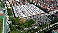
Kocaeli province, where İzmit is located, has 5 ports and 35 industrial docks. This makes it a very important place for transportation and trade. It's a gateway for goods going into and out of Anatolia (Asian Turkey). Major highways like the D100 and the Trans European Motorway connect Europe with Asia right through İzmit. The city's main train station, İzmit Central railway station, is one of the busiest in Turkey.
İzmit is also close to Istanbul's two international airports. Sabiha Gökçen International Airport is about 45 km (28 mi) away, and Atatürk International Airport is about 80 km (50 mi) away. These airports provide many national and international flight connections.
In 1958, a small passenger ferry called SS Üsküdar sank near İzmit due to bad weather. Sadly, 272 people died in this accident.
İzmit's Population Over Time
| Historical population | ||
|---|---|---|
| Year | Pop. | ±% p.a. |
| 2008 | 306,515 | — |
| 2012 | 327,435 | +1.66% |
| 2017 | 360,409 | +1.94% |
| 2022 | 376,056 | +0.85% |
| Source: TÜIK (2008-2022) | ||
Learning in İzmit

Kocaeli University (KOU) was founded in İzmit in 1992. It is a large university with over 50,000 students. The university works to be recognized internationally and offers many courses in engineering, social sciences, and arts.
İzmit's Weather
İzmit has a humid subtropical climate. This means it has hot and often humid summers. The average high temperature in July and August is around 30°C (86°F). Winters are cool and wet, with average low temperatures between 0-4°C (32-39°F) in January. It rains quite a lot throughout the year, especially in late fall and winter. İzmit has seen very high temperatures, like 44.1°C (111.4°F) in July 2000, and very low temperatures, like -18.0°C (-0.4°F) in February 1929. Snowfall is common, and the deepest snow recorded was 90 cm (35 in) in February 1929.
| Climate data for Akçakoca, İzmit (1991–2020, extremes 1929–2020) | |||||||||||||
|---|---|---|---|---|---|---|---|---|---|---|---|---|---|
| Month | Jan | Feb | Mar | Apr | May | Jun | Jul | Aug | Sep | Oct | Nov | Dec | Year |
| Record high °C (°F) | 24.9 (76.8) |
26.7 (80.1) |
30.8 (87.4) |
35.0 (95.0) |
37.2 (99.0) |
40.7 (105.3) |
44.1 (111.4) |
42.9 (109.2) |
40.2 (104.4) |
36.2 (97.2) |
29.1 (84.4) |
27.4 (81.3) |
44.1 (111.4) |
| Mean daily maximum °C (°F) | 10.0 (50.0) |
11.3 (52.3) |
14.0 (57.2) |
18.9 (66.0) |
23.8 (74.8) |
28.1 (82.6) |
30.3 (86.5) |
30.5 (86.9) |
26.7 (80.1) |
21.6 (70.9) |
16.6 (61.9) |
12.0 (53.6) |
20.3 (68.5) |
| Daily mean °C (°F) | 6.4 (43.5) |
7.1 (44.8) |
9.2 (48.6) |
13.2 (55.8) |
18.0 (64.4) |
22.3 (72.1) |
24.5 (76.1) |
24.8 (76.6) |
21.1 (70.0) |
16.7 (62.1) |
12.2 (54.0) |
8.4 (47.1) |
15.3 (59.5) |
| Mean daily minimum °C (°F) | 3.5 (38.3) |
3.9 (39.0) |
5.5 (41.9) |
8.9 (48.0) |
13.5 (56.3) |
17.6 (63.7) |
19.8 (67.6) |
20.4 (68.7) |
16.9 (62.4) |
13.3 (55.9) |
8.8 (47.8) |
5.6 (42.1) |
11.5 (52.7) |
| Record low °C (°F) | −13.1 (8.4) |
−18.0 (−0.4) |
−6.5 (20.3) |
−1.0 (30.2) |
1.8 (35.2) |
4.0 (39.2) |
10.1 (50.2) |
10.9 (51.6) |
4.9 (40.8) |
2.4 (36.3) |
−3.4 (25.9) |
−8.8 (16.2) |
−18.0 (−0.4) |
| Average precipitation mm (inches) | 100.1 (3.94) |
76.8 (3.02) |
77.8 (3.06) |
54.3 (2.14) |
55.4 (2.18) |
64.1 (2.52) |
48.3 (1.90) |
50.2 (1.98) |
52.0 (2.05) |
86.4 (3.40) |
74.7 (2.94) |
110.1 (4.33) |
850.2 (33.47) |
| Average rainy days | 17.87 | 16.43 | 15.97 | 12.70 | 11.67 | 9.73 | 6.83 | 6.13 | 9.77 | 13.30 | 13.47 | 18.13 | 152.0 |
| Average relative humidity (%) | 77.0 | 75.1 | 73.0 | 70.1 | 70.3 | 69.0 | 69.0 | 70.9 | 71.7 | 76.1 | 75.6 | 75.1 | 72.7 |
| Mean monthly sunshine hours | 77.5 | 87.6 | 133.3 | 180.0 | 217.0 | 261.0 | 288.3 | 269.7 | 204.0 | 139.5 | 105.0 | 77.5 | 2,040.4 |
| Mean daily sunshine hours | 2.5 | 3.1 | 4.3 | 6.0 | 7.0 | 8.7 | 9.3 | 8.7 | 6.8 | 4.5 | 3.5 | 2.5 | 5.6 |
| Source 1: Turkish State Meteorological Service | |||||||||||||
| Source 2: NOAA | |||||||||||||
| Climate data for Cengiz Topel Naval Air Station, İzmit (2013-2023) | |||||||||||||
|---|---|---|---|---|---|---|---|---|---|---|---|---|---|
| Month | Jan | Feb | Mar | Apr | May | Jun | Jul | Aug | Sep | Oct | Nov | Dec | Year |
| Mean daily maximum °C (°F) | 10.9 (51.6) |
12.7 (54.9) |
14.7 (58.5) |
19.6 (67.3) |
24.0 (75.2) |
27.6 (81.7) |
29.7 (85.5) |
30.6 (87.1) |
27.2 (81.0) |
21.6 (70.9) |
17.7 (63.9) |
12.9 (55.2) |
20.8 (69.4) |
| Daily mean °C (°F) | 5.8 (42.4) |
7.1 (44.8) |
8.6 (47.5) |
12.1 (53.8) |
16.7 (62.1) |
20.5 (68.9) |
22.5 (72.5) |
23.6 (74.5) |
19.9 (67.8) |
15.2 (59.4) |
11.6 (52.9) |
7.6 (45.7) |
14.3 (57.7) |
| Mean daily minimum °C (°F) | 0.5 (32.9) |
1.5 (34.7) |
2.5 (36.5) |
4.7 (40.5) |
9.4 (48.9) |
13.5 (56.3) |
15.3 (59.5) |
16.6 (61.9) |
12.6 (54.7) |
8.7 (47.7) |
5.4 (41.7) |
2.4 (36.3) |
7.8 (46.0) |
| Average precipitation mm (inches) | 93.4 (3.68) |
83.6 (3.29) |
78.2 (3.08) |
60.2 (2.37) |
61.1 (2.41) |
84.5 (3.33) |
49.1 (1.93) |
62.4 (2.46) |
60.8 (2.39) |
95.0 (3.74) |
69.8 (2.75) |
103.7 (4.08) |
901.8 (35.51) |
| Average extreme snow depth cm (inches) | 13.8 (5.4) |
9.2 (3.6) |
3.2 (1.3) |
0.0 (0.0) |
0.0 (0.0) |
0.0 (0.0) |
0.0 (0.0) |
0.0 (0.0) |
0.0 (0.0) |
0.0 (0.0) |
0.0 (0.0) |
4.7 (1.9) |
17.5 (6.9) |
| Source: Infoclimat | |||||||||||||
Images for kids
-
Fevziye Mosque
-
İzmit Clock Tower
-
İzmit Clock Tower
-
Pertev Paşa Mosque
-
Kasr-ı Hümayun
-
A view from İzmit's Demiryolu Avenue
-
Selim Sırrı Paşa Congress
-
Yeni Cuma Mosque
-
İzmit Perşembe Market
-
Izmit view


.JPG)


_02.jpg)
_03.jpg)


Sister Cities
İzmit has "sister city" relationships with many cities around the world. This means they share cultural ties and friendly connections. Some of these cities are:
 Agios Sergios, Northern Cyprus
 Buk (Busan), South Korea
 Čair (Skopje), North Macedonia
 Ceadîr-Lunga, Moldova
- Centar Župa, North Macedonia
 Ilidža, Bosnia and Herzegovina
 Karachi, Pakistan
 Kassel, Germany
 Kastrychnitski (Minsk), Belarus
 Kherson, Ukraine
 Momchilgrad, Bulgaria
 Nəsimi (Baku), Azerbaijan
- Pohang, South Korea
 Tiznit, Morocco
- Travnik, Bosnia and Herzegovina
 Vake-Saburtalo (Tbilisi), Georgia
- Vogošća, Bosnia and Herzegovina
Sports in İzmit
The main football (soccer) club in İzmit is Kocaelispor. They have many fans throughout the province. The city also has a women's football team called Derince Belediyespor. The multi-sport club Kocaeli B.B. Kağıt S.K. offers many different sports. Cycling is also popular, with a local team called Brisaspor. The Tour of Marmara cycling race is also held here.
İzmit has hosted several sports tournaments, including:
- The 2012 European Junior Open Water Swimming Championships
- The 2012–13 Turkish Cup Basketball
- The 2013 IIHF World Championship Division II (ice hockey)
- The 2014 IIHF World U18 Championship Division III (ice hockey)
- Matches for the 2014–15 EHF Champions League group stage (handball)
- The 2015 Boys' Youth European Volleyball Championship
Famous People from İzmit
- Saint Pantaleon
See also
 In Spanish: İzmit para niños
