
Tumtum Mountain facts for kids
Quick facts for kids Tumtum Mountain |
|
|---|---|

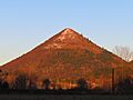
Tumtum Mountain seen from the west along NE Healy Rd in Chelatchie Prairie just before sunset.
|
|
| Highest point | |
| Elevation | 2,004 feet (611 m) |
| Prominence | approx. 880 feet (270 m) |
| Naming | |
| Etymology | Chinook Jargon |
| English translation | Heart |
| Geography | |

Tumtum Mountain
Location in Washington (state)
|
|
| Location | Clark County, Washington, US |
| Parent range | Cascade Range |
| Topo map | USGS Yale Dam |
| Geology | |
| Age of rock | Pleistocene |
| Mountain type | Lava dome |
| Type of rock | Dacite |
| Volcanic arc | Cascade Volcanic Arc |
| Last eruption | 70,000 years ago |
| Climbing | |
| Easiest route | Abandoned logging road to summit |
Tumtum Mountain is a small, very round volcano in Washington, United States. It's in northern Clark County, at the edge of a flat area called Chelatchie Prairie. The mountain is about 2,004 feet (611 meters) tall. That's about 1,400 feet (427 meters) higher than the prairie around it.
Tumtum Mountain is a type of volcano called a lava dome. It's made of a rock called dacite. This mountain is part of the Cascade Volcanic Arc, a chain of volcanoes. At about 70,000 years old, Tumtum Mountain is the newest and westernmost volcano in Washington's Cascade Mountains.
Contents
Where is Tumtum Mountain?
Tumtum Mountain is located in the foothills of the Cascade Range. It's about 2 miles (3 km) east of Washington State Route 503. You can reach it by taking NE Healy Road. This road starts near the Mount St. Helens National Volcanic Monument headquarters.
Healy Road becomes Forest Road 54 when it enters Gifford Pinchot National Forest. This road goes along the north side of Tumtum Mountain. There's a gated logging road on the north side that goes up the mountain.
From the top of Tumtum Mountain, you can see Mount St. Helens on clear days. Mount St. Helens is an active volcano about 19 miles (30 km) to the north. The historic Yale Bridge is about 2.5 miles (4 km) northwest. This bridge was built in 1932 over the Lewis River. Also, Yale Dam, a 323-foot (98-meter) tall hydroelectric dam, is about 2 miles (3 km) north of the mountain.
How Tumtum Mountain Formed
Tumtum Mountain likely formed when lava pushed up through a crack in the Earth. This crack is called the Chelatchie Fault. It runs along the south side of Chelatchie Prairie and under the mountain.
Most of the rocks around Tumtum Mountain are much older. They are mostly basalt lava flows and other materials. These rocks are 5 to 40 million years old and have been worn down over time.
Much later, during the Pleistocene Ice Age (between 10,000 and 2 million years ago), a huge glacier filled the Lewis River valley. This ice was very thick, reaching up to 2,000–2,500 feet (610–762 meters) high near Tumtum Mountain.
However, there is no sign that this glacier touched Tumtum Mountain. The mountain also doesn't show any signs of glacial erosion. This means Tumtum Mountain must be younger than the last big ice age in the area. Geologists believe it is about 70,000 years old.
What is Tumtum Mountain Made Of?
The rock that makes up Tumtum Mountain is called dacite. It is a very fine-grained rock, light tan to gray in color. It has about 68% silica, which is similar to the lava domes at Mount St. Helens.
The volcano's shape is made of broken pieces of this dacite rock. These pieces surround the main lava dome inside. There is also a small lava flow of dacite rock on the north side of the mountain's base. This lava flow sits on top of the glacial material left by the ice age.
History of the Land
Over many years, different logging companies have owned the land on Tumtum Mountain. These included Crown Zellerbach and Cavenham Forest Industries. Since 1988, a private logging company owner, Billie McKee Sr., has owned it.
At some point, one of these owners cut down all the trees on the mountain. In 2011, a large part of the mountain (about 360 acres or 150 hectares) was put up for sale. It was first priced at $1.4 million, but later the price was lowered to $699,900.
Images for kids
-
Tumtum Mountain seen from the west along NE Healy Rd in Chelatchie Prairie just before sunset.
