
Turtle-Flambeau Flowage facts for kids
Quick facts for kids Turtle-Flambeau Flowage |
|
|---|---|

View of the Turtle-Flambeau Flowage, looking Southwest from Fisherman's Landing
|
|

Turtle-Flambeau Flowage
Location in Wisconsin

Turtle-Flambeau Flowage
Location in the United States
|
|
 |
|
| Location | Iron County, Wisconsin, United States |
| Coordinates | 46°5′N 90°13′W / 46.083°N 90.217°W |
| Type | Drainage |
| Primary inflows | Flambeau River, Turtle River |
| Primary outflows | Flambeau River |
| Catchment area | 639.727 km2 (247.000 sq mi) |
| Basin countries | United States |
| Max. length | 15.4 km (9.6 mi) |
| Max. width | 15.3 km (9.5 mi) |
| Surface area | 52.37 km2 (20.22 sq mi) |
| Max. depth | 15 m (49 ft) |
| Shore length1 | 368.54 km (229.00 mi) |
| Surface elevation | 519.4 m (1,704 ft) |
| Frozen | Ice melts in late April-early May |
| Islands | Big Island, plus many others |
| Settlements | Mercer, Butternut |
| 1 Shore length is not a well-defined measure. | |
The Turtle-Flambeau Flowage is a large lake in Iron County, Wisconsin. It covers about 12,942 acres (52.37 square kilometers). This makes it the seventh largest lake in Wisconsin by its surface area. The lake is 15 meters (about 50 feet) deep at its deepest point.
This special lake is home to unique wetlands and many kinds of plants. It also has popular sport fish like Musky, Panfish, Largemouth Bass, Smallmouth Bass, Northern Pike, Walleye, and Sturgeon. The water in the lake is not very clear, but this can change in different parts of the lake.
Many people enjoy fishing, camping, boating, and hunting here. The Ojibwe people have also traditionally fished and hunted on the lake for a long time. There are some environmental worries for the flowage, such as mercury in fish, too much algae, and harmful invasive species.
Contents
How the Flowage Was Made
The area that is now the Turtle-Flambeau Flowage was once a mix of forests, open grassy areas, small lakes, and rivers. It was part of the natural river system for the Flambeau River.
The Turtle-Flambeau Flowage was created in 1926. A company built a dam on the Flambeau River. This dam was built just after the Flambeau River met the Turtle River. When the dam was finished, it flooded 16 natural lakes. This created a much larger body of water, covering about 14,000 acres (56.6 square kilometers).
The flowage was built to store water. This water could then be released to help power hydroelectric plants downstream. These plants make electricity using the force of moving water. The dam also helped prevent floods and created a great place for outdoor fun.
About the Flowage
Geography of the Area
The land area that drains into the flowage is called its watershed. This watershed covers almost 640 square kilometers (247 square miles). It is located in Iron and Vilas Counties. Almost half of this area (47%) is covered by forests. Another 33% is wetlands, including a special area called the Turtle-Flambeau Patterned Bog State Natural Area. About 19% of the watershed is open water.
Not many people live or farm in this area. Farms, towns, and cities make up less than 1% of the land use.
Geology and Land Features
The Turtle-Flambeau Flowage sits on top of a large granite rock formation. This rock formed billions of years ago. The ground here is mostly sandy. This is because of the old coniferous forests that grew after the glaciers left.
Most of the rocks and land shapes in this area were made by glaciers. These huge ice sheets carved out the land or left behind rocks and soil as they melted. The bottom of the flowage is made of about 45% sand, 30% gravel, 15% muck (wet dirt), and 10% rock.
How Water Moves in the Flowage
The Turtle-Flambeau Flowage is a "drainage lake." This means most of its water flows out into other rivers. It gets its water from several rivers, including the Flambeau River and Turtle River. The water then flows out of the Turtle Dam back into the Flambeau River.
The amount of water released from the dam changes a lot. It depends on how high the lake's water level is and how much electricity the power company needs to make. On average, the dam releases about 20 cubic meters (about 700 cubic feet) of water per second.
The flowage has an irregular shape because it was formed by flooding many old lakes. This gives it a very long and winding shoreline. About 35% of the flowage's surface area used to be these old lake basins. The rest is made up of shallow river areas.
Water Quality in the Flowage
The water quality is different in various parts of the flowage. For example, the Baraboo basin has better water quality than the Townline basin. Some parts of the lake have a lot of nutrients, like eutrophic lakes. Other parts are more balanced, like mesotrophic lakes.
The flowage is a healthy lake. You can usually see about 1.5 meters (5 feet) down into the water in the summer. This is measured with a Secchi disk. The lake also has a single layer of warm, productive water on top and cooler water below.
- Comparison of Secchi depth, chlorophyll ''a'', total phosphorus, temperature, and dissolved oxygen in Baraboo and Townline basins of the Turtle-Flambeau Flowage
-
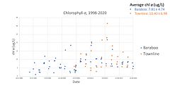
Comparison of chlorophyll a levels in Baraboo and Townline basins of the Turtle-Flambeau Flowage
-
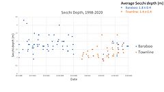
Comparison of Secchi depth in Baraboo and Townline basins of the Turtle-Flambeau Flowage
-
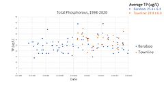
Comparison of total phosphorus levels in Baraboo and Townline basins of the Turtle-Flambeau Flowage
-
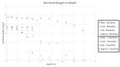
Comparison of dissolved oxygen vs depth measurements in Baraboo and Townline basins of the Turtle-Flambeau flowage
-
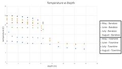
Comparison of temperature vs depth measurements in Baraboo and Townline basins of the Turtle-Flambeau flowage


Wildlife of the Flowage
Plants and Trees (Flora)
Even though trees don't live in the water, they can affect lake levels. Tree roots pull water from the moist shoreline through a process called transpiration. This can lower the amount of water in the lake. Some trees, like the White Cedar, are better at moving water than others, like the Red Pine or Sugar Maple.
There's a special peatland in the southeast part of the lake. It has peat ridges and water-filled hollows, which is rare in Wisconsin. Some rare plants found here include sparse-flowered sedge, dragon's mouth orchid, and white bog orchid.
Animals (Fauna)
The flowage is home to many different animals.
- Fish: Native fish include Musky, Panfish, Largemouth Bass, Smallmouth Bass, Northern Pike, Walleye, and Sturgeon. Fish are also added to the lake at several points to help keep populations healthy.
- Reptiles: You can find snapping turtles and painted turtles here.
- Birds: The Turtle-Flambeau Flowage is a great place for loons. It also has the most eagle and osprey breeding pairs in Wisconsin.
- Mammals: Mammals living around the flowage include river otter, beaver, black bear, and white-tailed deer. A lot of deer grazing in the area can make it hard for new conifer trees to grow.
Environmental Concerns
Mercury in Fish
High levels of methylmercury have been found in walleye fish in the Turtle-Flambeau Flowage. This is a concern because walleye are a traditional food for the Lake Superior Chippewa people. Eating fish with mercury can be harmful to humans.
Wetlands can be a source of methylmercury. Also, when water levels change a lot from dam releases, it can increase mercury in the lake. Because of mercury, the flowage was declared "impaired" in 2002. A warning about eating fish from the lake has been in place since 2009.
Algae Growth
The lake also has high levels of phosphorus and chlorophyll a. These are signs of too much algal growth. The Mercer wastewater treatment plant, which releases water into a nearby river, might add some phosphorus. Mercer Lake, which is close by, sometimes has a lot of algae when the plant releases a lot of water. However, dark water from the surrounding wetlands helps reduce the impact of harmful algal blooms in the flowage.
Invasive Species
Invasive species are plants or animals that are not native to an area and can cause harm.
Faucet Snail
The faucet snail is an invasive snail from Europe. It can outcompete native snails in the Great Lakes region. This snail has been seen in Spider Lake, which flows into the Turtle-Flambeau Flowage.
Purple Loosestrife
Purple loosestrife is an invasive plant from Asia and Europe. It has been found in many lakes and rivers in Wisconsin, including the Turtle-Flambeau Flowage. A local property owners' group keeps an eye on this plant. They do surveys every year and map where it has been seen.
Spiny Waterflea
The spiny waterflea is a tiny, spiny animal that eats other small water creatures. It competes with young native fish for food. Because of their spiny tails, bigger fish don't often eat them. While not yet found in the Turtle-Flambeau Flowage, it is in nearby lakes. This species could spread to the flowage on dirty boat hulls, bilge tanks, or fishing lines.
Monitoring Efforts
Local groups help manage the lake. The Turtle-Flambeau Flowage & Trude Lake Property Owners Association, Inc. has worked to check the water quality. The Iron County Land and Water Conservation Department also monitors and acts against invasive species. They have used beetles to control purple loosestrife and checked boating practices at lake landings.
Cultural Importance
Indigenous History
The lakes that became the Turtle-Flambeau Flowage were originally part of the Ojibwe people's land. The Lac du Flambeau band of Ojibwe settled in the area around 1745.
Early Europeans in the region were likely French fur traders and trappers.
In 1854, the Ojibwe officially gave up some of their territories, including what is now Iron County. However, the Wisconsin State Constitution says that all navigable waters (waters that can be used for boats) are public. This means the Flambeau River and the land it floods are for public use. Companies and landowners still have some rights to the water near their property.
Even though the Turtle-Flambeau Flowage was created after the Ojibwe lands were given up, the waterways have been part of many disagreements about treaties. The 1854 treaty allowed the Ojibwe to hunt and fish on their former lands. However, Wisconsin tried to control these activities. In 1983, a court confirmed the tribes' right to fish and hunt on all ceded territories, not just reservations. This led to some tension. Despite this, tribal walleye spearfishing on the flowage is a small part of the total walleye caught.
Fishing Fun
Many fish in the Turtle-Flambeau Flowage are popular with anglers. Fish like Walleye, Northern Pike, and Muskellunge are popular for catching. They have special fishing seasons to protect them. Other common fish include smallmouth bass, rock bass, bluegill, black crappie, and bullhead catfish. The walleye population is strong, though numbers have changed over time.
Most people use a rod and reel to fish. However, members of the Ojibwe people have the right to spearfish for walleye, as mentioned above.
Tourism and Recreation
The Turtle-Flambeau Flowage is a popular place for summer tourism. Visitors can get to the lake from four public boat landings. Camping, hunting, and fishing are also very popular activities.
The Turtle-Flambeau Scenic Waters Area has 60 remote campsites. You can only reach these sites by water. They are open all year and are available first-come, first-served. There is no fee to camp, but you must use the marked sites.
In the past, there were many lakeside resorts near the flowage. Today, much of the shoreline is still undeveloped, keeping it wild and natural.
Images for kids
