
Urfa facts for kids
Quick facts for kids
Urfa
|
||
|---|---|---|
|
City
|
||
| Şanlıurfa | ||
|
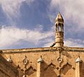
Clockwise from top: View of Urfa, Urfa Castle, Ayn Zeliha, St. Johannes Prodromos Addai Church, Rizvaniye Mosque
|
||
|
||
| Nickname(s):
City of Prophets
|
||

Urfa
Location in Turkey

Urfa
Location in Near East
|
||
| Country | Turkey | |
| Province | Şanlıurfa | |
| Founded | 303/302 BC | |
| Founded by | Seleucus I Nicator | |
| Elevation | 477 m (1,565 ft) | |
| Population
(2022)
|
||
| • Urban | 596,637 | |
| Time zone | UTC+3 (TRT) | |


Urfa, officially known as Şanlıurfa, is a city in southeastern Turkey. It is the capital of Şanlıurfa Province. In ancient times, it was called Edessa. Urfa is located on a flat area about 80 kilometers (50 miles) east of the Euphrates River. The city has very hot, dry summers and cool, wet winters.
About 12 kilometers (7.5 miles) northeast of Urfa is Göbekli Tepe. This is the world's oldest known temple, built around 10,000 BC. The area around Urfa was one of the first places where humans settled and started farming. Urfa is nicknamed the "City of Prophets." This is because it is linked to Jewish, Christian, and Islamic history. A legend also says it was the hometown of Abraham.
Religion is very important in Urfa. The city is known as one of the most religious places in Turkey. Urfa is also near the Atatürk Dam. This dam is part of a big project that brings many people looking for jobs to the city each year.
Contents
- What's in a Name?
- City's Location and Weather
- A Look Back in Time
- Main Attractions
- Parks
- Images for kids
- Religious Importance
- People of Urfa
- Urfa's Economy
- Urfa's Culture
- Education
- Getting Around
- See Also
What's in a Name?
The oldest name for the city is Orhay, from the Syriac language. This name might mean "to bring water" or "beautiful flowing water."
In the 1800s, people called the city Ruha. With an Arabic article, it became Ar-Ruha, then Urha, and finally Urfa. In Kurdish, the city is called Riha. In Armenian, it is Urha.
In 1984, the Turkish government added "Şanlı" to Urfa's name. "Şanlı" means "glorious." This was to honor the people of Urfa for fighting against British and French soldiers during the First World War. That's why its official name is now Şanlıurfa.
City's Location and Weather

Urfa sits where the Taurus Mountains meet the huge Mesopotamian plain. It's in a flat area that extends westward, hidden behind hills.
A small stream, the Daisan River, flows through Urfa. It's called the "leaping river" because it used to flood a lot. Today, the Daisan flows through a man-made channel. This channel goes along the north and east sides of the old city. Part of the old river path is now a fish pool called Birket Ibrahim. People believe this pool is connected to the prophet Abraham.
Since the 1900s, Urfa has grown northward. New buildings have been built across the plain and over the hills.
Urfa's Climate
Urfa has a hot-summer Mediterranean climate. This means summers are very hot and dry, with almost no rain. Average high temperatures often go above 40°C (104°F). Winters are cool and quite wet. Frost is common, and sometimes it snows a little. Spring and autumn are warm and mostly dry.
The highest temperature ever recorded was 46.8°C (116.2°F) on July 30, 2000. The lowest was -12.4°C (9.7°F) on February 9, 1932.
A Look Back in Time
Early History
.jpg)
The Urfa area is home to some of the oldest human settlements. Göbekli Tepe, the world's oldest known temple, is nearby. Settlements here started around 9000 BC. This was when people began to farm instead of just hunting and gathering.
Even though there isn't much written about it, Urfa's good location for trade suggests it was a small settlement before 303 BC. The area was great for early humans because it had lots of grazing land and wild animals.
In Urfa itself, an ancient village was found under modern houses. It was discovered by accident in the 1990s. Tools, arrowheads, and round buildings were found there. People hunted animals and grew wheat and barley. This village dates back to about 9400–8600 BCE.
Bronze Age Changes
Around 3200 BC, during the Uruk period, villages like Urfa and Harran started to become cities. By the Early Bronze Age (2900-2600 BCE), Urfa was a walled city covering a large area. This old city is at the Kazane Tepe site, next to modern Urfa. Some think it might be the ancient city of Urshu.
The City of Edessa
Urfa was founded as a city called Edessa by King Seleucus I Nicator in 303 or 302 BC. He named it after an ancient city in Macedonia.
Ancient writings say Edessa was built like a typical Greek military town. It had streets in a grid pattern, four main streets, and four city gates. Soldiers from Macedonia settled there, but they were never most of the people. The city's culture stayed mostly Semitic (Aramaic).
Edessa was an important trading hub in the 3rd and 2nd centuries BC. The main trade route used to go through Harran, but after Edessa was built, it moved north.
As the Seleucid Empire weakened, Edessa became the capital of the Abgarid kingdom of Osrhoene around 132 BC. The Abgarids were likely an Arab family. They often sided with the Parthian Empire.

In the early 100s AD, the Abgarids came under Roman influence. Sometimes they supported Rome, sometimes they rebelled. The Romans captured and destroyed Edessa once, but the Abgarids usually got their power back. By 166 AD, Osrhoene became a Roman client kingdom, meaning it was allied with Rome.
Abgar VIII, also called Abgar the Great, ruled from 177 AD. He focused on arts and learning. In 201 AD, a big flood destroyed much of Edessa. Abgar helped rebuild the city.
In 1979, seven ancient tombs were found in Urfa. Mosaics in these tombs might show members of the Abgarid family.

Ancient Edessa was a mix of different religions. People worshipped many gods, often linked to planets. There was also a strong Jewish community, many of whom were merchants. By the late 100s AD, a small Christian community appeared. Christianity spread quickly, partly because of the Jewish community.
Some say Abgar the Great became Christian around 200 AD. If true, Edessa would have been the first Christian state in the world. Other religions, like the Bardaisanites and Manichaeism, also became popular in the 200s AD.
Edessa Under Roman Rule
After Abgar the Great died in 212 AD, Edessa lost its independence. In 214 AD, the Roman emperor Caracalla made Edessa a Roman colony. This officially ended the city's self-rule.
In 260 AD, the Sasanian emperor Shapur I defeated the Romans in the Battle of Edessa. However, it's not clear if he actually captured the city.
In 298 AD, Edessa became the capital of a new Roman province called Osrhoene. It was an important military base for the Roman Empire.
Edessa in Late Antiquity
From the 300s to 500s AD, Edessa was very successful. It was a major trading hub, especially for silk from the East. The city had a council of important citizens who helped govern. There were several religious schools, including the famous School of the Persians. Many churches and monasteries were in and around the city.
When the Roman emperor Jovian gave Nisibis to the Sasanians in 363 AD, many Christians moved to Edessa. One of them was the writer Ephrem the Syrian.
In 525 AD, a flood damaged the city. After that, a deep ditch was dug to control floods. Over time, this ditch became the normal path of the Daisan River.
Edessa survived a siege in 544 AD. But in 609 AD, the Sasanian emperor Khosrow II captured it. Later, in 628 AD, the Byzantine emperor Heraclius took Edessa back.
The Age of Islam
Urfa surrendered to the Muslim general Iyad ibn Ghanm in 639 AD without a fight. The agreement allowed Christians to keep their cathedral. Soon after, a mosque was built in the city.
In the early years of Arab rule, Urfa was still a major Christian city. It had many churches and monasteries. Most people were Syrian Orthodox Christians, with some Melkite Christians and Jews. There were few Muslims. The city was run by a group of important citizens.
Around 812 AD, new defensive walls were built around the city. The walls and towers you see today are from this time, though they have been repaired since.
In 943 AD, the Byzantine army came to Mesopotamia. They demanded that the mandylion, a famous Christian relic (a holy item), be given to the emperor. In return, the city would be safe, and 200 Muslim prisoners would be freed. With permission from the caliph, the people of Edessa handed over the mandylion. It was taken to Constantinople in 944 AD.
The 11th Century
In 1031, the Byzantine general George Maniakes conquered Edessa. This was one of the last big land gains for the Byzantine Empire in Mesopotamia. The city became an important Byzantine center.
In 1071, the Seljuk sultan Alp Arslan besieged Urfa for 50 days. He eventually left after receiving a large payment. After the Battle of Manzikert, Edessa was supposed to go to the Seljuks, but political changes kept it under Byzantine control for a while.
In the 1080s, an Armenian named Toros took charge of the city. He started rebuilding a fortress, but it was finished later. During the 11th century, many Armenian immigrants moved to the region, especially to the towns. In Urfa, they became important citizens and landowners.
The County of Edessa

Urfa became the capital of the crusader County of Edessa around 1098. This lasted for about 50 years. The people living there were a mix of Armenians and Syrians. Armenians were the main group in Urfa itself. The crusaders didn't build much in Urfa.
Sieges of 1144 and 1146
The County of Edessa survived because its Muslim rivals were not united. But then Imad ad-Din Zangi, a powerful leader from Mosul, rose to power. In late 1144, the crusader count Joscelin II left Edessa with many soldiers. Zengi saw this as a chance.
Zengi quickly marched to Edessa and besieged the city on November 24. By December 24, he had entered the city. The castle fell two days later. Zengi's forces spared the local Christians and their churches. But the Franks (crusaders) were killed, and their churches were destroyed. Zengi appointed a new governor for the city.
The fall of Edessa led to the Second Crusade. News of the city's capture spread, and Christian leaders called for a new crusade. Zengi became a hero in the Muslim world.
In May 1146, Armenians in Urfa tried to overthrow the Turks and give the city back to Joscelin II. The Turks stopped this plan. After Zengi was killed in September 1146, the Armenians tried again with Joscelin II.
In October, Joscelin II and his allies besieged the city again. This second siege was much more destructive. The Franks entered the city but couldn't take the main castle. They looted shops, both Christian and Muslim. The city's Muslims either fled or hid in the castle.
Meanwhile, Zengi's son, Nur ad-Din Zengi, arrived with a large army. The Franks realized they were trapped and tried to escape. Many were killed. The city's people were massacred; men were killed, and women and children were sold as slaves. Urfa's Christian community, one of the oldest in the world, was destroyed and never fully recovered.
Zengid and Ayyubid Rule
After Nur ad-Din died in 1174, his nephew Sayf al-Din Ghazi II captured Urfa.

Saladin captured Urfa in 1182 after a siege. He then had to besiege the castle separately. He paid the defenders to take control of the castle. Saladin appointed Muzaffar al-Din Gökböri as governor of Urfa and Harran. During Saladin's rule, the Melkite Christian cathedral was torn down. Some of its stones were used for Urfa's castle.
Urfa was part of a larger area ruled by Saladin's family, the Ayyubids. During Ayyubid rule, Urfa had about 24,000 people.
In 1234, the Seljuk sultan Kayqubad I's army took the city, and its people were sent to Anatolia. But the Ayyubid ruler al-Kamil recaptured it within four months. Soon after, al-Kamil ordered the castle to be partly destroyed.
Mongol Rule
In 1260, Urfa peacefully surrendered to the troops of Hulagu, a Mongol leader. Because the city surrendered without a fight, its people were spared.
The Mongols didn't keep soldiers in Urfa. It was too close to their western border and hard to defend. The city was mostly empty, with only nomadic people living there.
Mamluk and Aq Qoyunlu Rule
The Mamluks took control of Urfa in the early 1300s. They rebuilt the ruined castle, but few people lived in the city. Urfa had little trade importance because merchants used other routes.
This changed in the late 1300s. Some trade started to pass through Urfa again, and the city began to be repopulated. By 1400, Urfa was rebuilt and doing well. In 1394, Timur occupied Urfa without much resistance.
The Aq Qoyunlu (a Turkic tribal group) took over Urfa in the early 1400s. They saw it as an important military outpost. In 1429, the Mamluks attacked Urfa. They sacked the city, destroyed the fortress, and enslaved many people.
In 1451, a battle took place in Urfa where Uzun Hasan defeated other Aq Qoyunlu leaders. He later became the main ruler. In 1462-63, Urfa's castle was renovated under Uzun Hasan.
In 1480, a large Mamluk army besieged Urfa. They used cannons and catapults. Aq Qoyunlu forces arrived and a big battle happened. The Mamluks were completely defeated.
Ottoman Period

Urfa became part of the Ottoman Empire around 1517. Early records show about 5,500 people living there. By 1566, the population had grown to 13,000 to 14,000. Urfa became a majority Turkish city during this time.
Urfa thrived under Ottoman rule. Trade and industries grew, and its population increased. It was an important trading stop between Iran and Aleppo.
However, this prosperity also attracted bandits. In the late 1500s, a revolt led by Karayazıcı Abdulhalim turned Urfa into a battlefield. His army took control of the city's castle. Ottoman troops eventually fought back and retook the city.
The fighting caused Urfa's prosperity to decline. By the 1600s, parts of the city were in disrepair. Many people living there were nomads who only needed homes in winter.
In 1638, Sultan Murad IV stayed in Urfa and ordered the castle to be restored.
The writer Evliya Çelebi visited Urfa in 1646. He described houses made of mud brick, with richer homes having gardens. He counted 22 mosques and many shops. Urfa was known for its yellow leather and cotton fabrics.
In the 1700s, Urfa faced problems like banditry and poverty. A serious plague hit in the 1780s, killing many people. To repopulate the city, people from Iraq, especially from Kirkuk, were resettled in Urfa. This connection left cultural traces in Urfa.
The 19th Century

In the 1800s, Urfa was a trade center because it was at a crossroads. Many Jewish, Armenian, and Greek merchants lived there.
James Silk Buckingham visited Urfa in 1816. He noted that houses were now made of fine stone, like those in Aleppo. Urfa had a busy cotton trade and also produced wool cloth and rugs.
In the late 1800s, Urfa's importance as a trade center declined. The opening of the Suez Canal in 1869 shifted trade routes away from overland caravans. The local economy focused more on meeting the basic needs of its people. Workshops made cheaper goods, and imports decreased.
The main shopping areas were the bazaars. Each bazaar was often named after what it sold, like the İsotçular Çarşısı for chili peppers. Many inns (hans) were built for travelers. Muslims and non-Muslims used the same inns.
In the countryside, life stayed mostly the same. Farmers used old methods. Droughts and locusts sometimes caused problems, making it hard to collect taxes.
Until the mid-1890s, about 20,000 of Urfa's 60,000 residents were Armenians. In 1895, thousands of Armenians were killed in massacres. First, Turkish and Kurdish locals killed hundreds. Then, the Armenian quarter was cut off from food and water. In December, soldiers and civilians entered and killed thousands more. About 3,000 survivors sought shelter in a church, but soldiers burned it down, killing everyone inside. Around 8,000 Armenians were killed in total.
There was also a small, ancient Jewish community of about 1,000 people. Most of them left in 1896, fleeing the massacres, and settled in places like Aleppo and Jerusalem. The last Aramaic-speaking Christians left in 1924.
First World War and After
During the First World War, Urfa was a site of the Armenian and Assyrian genocides, starting in 1915. Armenians from Urfa were deported and killed. Urfa was also a stop on the deportation route for Armenians from other cities. Massacres happened in Urfa itself. In October, the Urfa resistance took place, where Armenians fought back. Thousands of Armenian deportees were killed in and around Urfa.
Meanwhile, many Turks fleeing Russian occupation in other regions settled in Urfa.
At the end of World War I, the Treaty of Sèvres placed Urfa in French-controlled Syria. British and then French troops occupied Urfa. Locals formed a militia and drove out the foreign troops on April 11, 1920. The 1923 Treaty of Lausanne officially made Urfa part of the new Republic of Turkey. Urfa became the capital of its province in 1924.
Urfa in the 21st Century
During the Syrian Civil War, thousands of Syrian refugees came to Turkey, and many settled in Urfa. When Raqqa became the capital of the Islamic State, Urfa became a gateway for people entering Syria because it was so close to the border.
On February 6, 2023, Urfa was damaged by the Turkey-Syria earthquakes.
Main Attractions

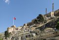
- Urfa Castle – This ancient castle has walls built by the Abbasids in 814 AD.
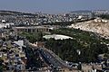
- The legendary Pool of Sacred Fish (Balıklıgöl) – Legend says Abraham was thrown into fire here by Nimrod. The flames turned into water, and the wood into fish. The pool is in the courtyard of the Halil-ur-Rahman Mosque.
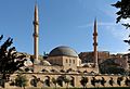
- Rızvaniye Mosque – A newer Ottoman mosque (1716) next to the Balıkligöl complex.
- 'Ayn Zelîha – A spring near the old city, named after Zulaykha, a follower of Abraham.
- The Great Mosque of Urfa – Built in 1170 on the site of an old Christian church.
- Ruins of the ancient city walls.
- Eight Turkish baths from the Ottoman period.
- Traditional Urfa houses – These homes were divided into sections for family (harem) and visitors (selâm). You can visit an example near the post office.
- The Temple of Nevali Çori – A Neolithic settlement from 8000 BC, now mostly underwater due to the Atatürk Reservoir.
- Göbekli Tepe – The world's oldest known temple, dating back about 11,500 years.
The Castle
Urfa Castle is on a rocky hill south of the old city. It's long and thin, following the shape of the ridge.
The hilltop was once home to a palace in the 200s AD. The first known fortifications were built in the early 500s AD. The fortress was well-kept during the Middle Ages and survived many attacks.
It was destroyed around 1235 but rebuilt in the early 1300s. It was renovated again in the 1400s and several times under the Ottomans. The castle had soldiers until 1826. By then, it was already falling apart. In 1849, a local citizen took stones from the castle to build an inn and market.
Old City Walls


The large walls around the old town were built during the Abbasid period in 812 AD. The main repairs happened in the early Ottoman period (1660–61). The walls are made of big stone blocks. In many places, people have built houses right against the inner side of the wall.
There were three main gates: the Harran Gate, the Bey Kapısı ("Lord's Gate"), and the Saray Kapısı ("Palace Gate"). The Harran Gate still exists. Its outer side was rebuilt by the Ottomans, but the inner side dates back to the Ayyubid period (1200s AD). It has a relief of a double-headed eagle.
The Bey Kapısı, on the east side, also still stands, though the actual gate is gone. It was originally built in ancient times and later turned into a fortress. The Armenian prince Toros started rebuilding it, and the crusaders finished the work. It was rebuilt again by the Ottomans. Today, it's mostly a private home.
The Saray Kapısı no longer exists. It was on the north side of town.
Balıklıgöl and its Mosque

The Balıklıgöl is famous for its legend. It's said that when Abraham destroyed Nimrod's idols, Nimrod threw him into a fire. But the fire turned into water, and the burning wood became carp fish.
Halil ür-Rahman Cami

The Halil ür-Rahman Cami (Halil Mosque) is on the south side of the pool. A cave just south of the mosque is believed to be where Abraham was born. Another legend says Abraham was going to sacrifice his son here, but sacrificed a goat instead, and a spring gushed out, feeding the fish pool.
The mosque's minaret was built in 1211–12. The main prayer hall was rebuilt in 1819–20. There are also school rooms (medrese cells) built in 1808–09. The mosque is now an entrance to the cave.
Ayn Zeliha
The Ayn Zeliha pool, named after Nimrod's daughter, is south of the main pool. It's a shady spot with cafes.
Haleplibahçe Museum Complex

The Haleplibahçe museum complex is near Balıklıgöl. It has two museums: the Şanlıurfa Museum and the Haleplibahçe Mosaic Museum. The Şanlıurfa Museum is Turkey's largest museum. It has 14 exhibition halls and about 10,000 artifacts from different time periods. These include finds from Göbekli Tepe and Harran. The Mosaic Museum was built right over where the Haleplibahçe mosaics were found. It has the oldest known mosaic showing the Amazons.
Kızılkoyun Necropolis
East of the museum complex is the Kızılkoyun necropolis. This is a burial site with at least 75 tombs carved into limestone rock. They were made during the Roman period (200s-300s AD). The tombs vary in size and some have statues and mosaics.
The area was once covered by informal housing. In 2012, the houses were removed, and a new project started to protect the ancient site.
Grand Mosque
The 12th-century Grand Mosque of Urfa is a large mosque for community prayers.
Covered Market (Kapalı Çarşı)

The Kapalı Çarşı is a "maze-like" covered market area. It's full of shops and stalls selling herbs, spices, fabrics, and more. The market is covered to keep people cool in summer and warm in winter.
It's one of the busiest shopping areas, used by locals and tourists. It's a very traditional marketplace. Artisans here make shoes, saddles, and metal goods.
Some bazaars inside the Kapalı Çarşı include the Kazaz (Bedesten), Sipahi Pazarı, Bakırcılar Çarşısı (coppersmiths' market), and Kuyumcular Çarşısı (jewelers' market).
Gümrük Hanı

The Gümrük Hanı, or "customs caravanserai," is in the middle of the Kapalı Çarşı. It's a two-story building with a square courtyard. The ground floor has shops, and the upper floor has rooms now used as apartments. The shady courtyard has teahouses.
Bedesten

The bedesten is an important market in the Kapalı Çarşı. It was built in 1562 and restored in 1998. It has entrances to four surrounding bazaars.
Tabakhane Cami
The Tabakhane Cami, or "dye-house mosque," dates from the 1700s or early 1800s. Its minaret might be older. The mosque has a main prayer hall and a courtyard.
Kara Meydanı
The Kara Meydanı is at the north end of Divan Caddesi. The 19th-century Yusuf Paşa Cami is here, as is the old Haci Hafiz Efendi house, now an art gallery.
Parks
The Akabe recreation area is a large park covering 100,000 square meters. It has sports fields, playgrounds, walking trails, and an archery range. It was built to make Urfa greener.
Images for kids
-
Mevlid-i Halil Mosque, built next to the site where prophet Abraham is believed to have been born.
-
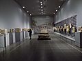
Interior of the Şanlıurfa Museum
-
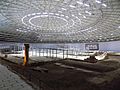
Interior of the Haleplibahçe Mosaic Museum
-
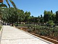
Gölbaşı-Garden
-
Ruins of Urfa castle
-
Urfa Armenian Protestant church
-
Ayn Zeliha
-
The museum complex, viewed from the south: in the foreground is the Haleplibahçe Mosaic Museum; in the background is the Şanlıurfa Museum.
-
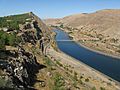
Euphrates River
-
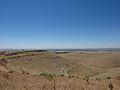
Surrounding fields of Göbekli Tepe, the site of the oldest temple in the world.


Religious Importance
Some Jewish and Muslim sources say Urfa is Ur Kasdim, the hometown of Abraham. However, scholars disagree on this. Urfa is also one of several cities linked to the prophet Job.
For Armenians, Urfa is very important. They believe the Armenian alphabet was invented there.
People of Urfa
Historical Demographics
The people of Urfa have changed a lot over centuries. In ancient times, there were Greeks, Arabs, Syrians, and Armenians. During the First Crusade, most people were Armenian or Assyrian.
An ancient Jewish community lived in Urfa, with about 1,000 people by the 1800s. Most left in 1896 because of massacres, settling in places like Aleppo and Jerusalem. In the early 1900s, Urfa had Arabs, Kurds, and many Armenians.
The Armenian and Assyrian Genocides led to the killing and forced removal of many Christians in Urfa. After Turkey became a republic, most remaining non-Muslims left the city due to ongoing persecution.
Languages Spoken
In the early 1800s, Turkish was the main language. Armenian, Syriac, Kurdish, Arabic, and Persian were also spoken. Armenians often spoke Turkish to strangers, while Assyrians spoke Arabic.
Present-Day Population
Today, the city is mainly made up of Arabs, Kurds, and Turks.
Syrian Refugees
Since the Syrian Civil War started, many refugees from Syria have settled in Urfa. This is because it's close to the border and has job opportunities. As of 2017, about 300,000 Syrians live in Urfa province. Most are Arabic-speakers, but some are Kurdish-speakers.
Syrians in Urfa often live in areas with lower rent. Homes are often small, with several families sharing one place. Syrians with less money live in older neighborhoods. The largest numbers of Syrians are in the Haliliye and Eyyübiye districts.
Syrian refugees often face money problems and unemployment. The language barrier makes it hard to fit in with the local community. Many Syrians start their own businesses, like street vendors.
Before 2017, Syrians and Turks got along well. But after 2017, some Turks started to blame Syrians for economic problems. The increase in Syrian businesses and lower wages have caused some anti-Syrian feelings. In 2019, local officials made all Syrian-owned businesses use Turkish-language signs.
Urfa's Economy

As of 2018, the average income in Urfa was about $4,400 USD per year. Unemployment was 18%, and for young people, it was 35%.
Urfa is a big center for making shoes. About 5,000 people work in this industry. A large shoe factory opened in Urfa in 2012, employing 900 people. There are plans to open more factories and create many more jobs.
Urfa is also a major producer of pistachio nuts. However, most of the processing is done in Gaziantep, another big pistachio city.
Handicrafts
Urfa has a long history of handicrafts. These include coppersmiths, furriers, weavers, carpetmakers, and jewelers. Historically, each trade had its own market. However, many of these crafts are declining today, and fewer young people are learning them.
Copper-smithing and jewelry making are still doing relatively well. Making prayer beads is also popular. Woodcarvers are needed for restoring old buildings. But traditional leather tanning and handmade embroidery are no longer widely practiced for commercial purposes.
Limestone Quarrying

There is a lot of limestone in the Urfa area. It has been used for building since ancient times. This limestone is light, whitish-yellow. When it's first taken from the ground, it's soft and easy to cut. But once it's exposed to air, it hardens and becomes a strong building material.
Urfa limestone was used at Göbekli Tepe 12,000 years ago. There are also old Roman quarries. Many old quarries are underground, forming caves. Today, there are still active limestone quarries around Urfa.
Urfa province has huge limestone reserves. Many stone blocks are sent to other cities for processing. Before reinforced concrete became common, Urfa limestone was the main material for big construction projects. Many historical buildings in Urfa, like the castle, city walls, and mosques, were built with this limestone. It's also used in modern buildings.
Industrial Zones
Organized Industrial Zone
The Organized Industrial Zone is 17 kilometers (10.5 miles) west of Urfa. It started in 1991 and covers a large area. It has about 250 companies and employs around 13,000 people.
Evren Industrial Estate
The Evren Industrial Estate is a smaller industrial area about 7 kilometers (4.3 miles) west of Urfa. It opened in 1994 and has about 1,500 businesses. Urfa's limestone quarries are also located here.
Urfa's Culture
Delicious Food

Urfa's unique food mixes the cuisines of many different civilizations that have ruled the city. Many believe Urfa is the birthplace of dishes like Çiğ köfte. Legend says Prophet Abraham made it from ingredients he had on hand.
Meat dishes are a big part of meals in Urfa. People often eat lahmacun and kebab daily. Ciğer kebabı, or liver kebab, is popular, especially because liver is usually cheap.
The walnut-stuffed Turkish dessert crepe called şıllık is a local specialty. Legend says its sweet syrup was first made using molasses from the Hanging Gardens of Babylon.
Warm Hospitality
People in Urfa traditionally value hospitality very much. Inviting guests over and sharing food is very important. Locals say this comes from Prophet Abraham, who supposedly never ate alone and always had guests.
Literature and Poetry
Urfa has a long history of literature, with early Christian writers like Bardaisan. Later, from the 1600s to the 1900s, a type of poetry called divan became popular. Many of these poets were Sufis, who gathered in religious schools.
Traditional Houses

Urfa's old town has many traditional courtyard houses, many built in the 1800s. A typical house has a high-walled courtyard closed off from the street. Facing the courtyard is a covered antechamber called a mastaba. Other rooms include bedrooms, a kitchen, and a sitting room. There's also a semi-basement called a zerzembe for storing food in winter.

An important idea in house design is mahremiyat, which means "privacy." This is especially important for keeping men and women separate outside the immediate family. So, traditional Urfa houses are built to prevent outsiders from seeing the women of the household.
Local Turkish Language
The Turkish spoken in Urfa has some unique features. It shares some sounds with the Iraqi Turkmen language and has some Arabic influences. For example, some Arabic sounds are pronounced the same way in Urfa Turkish as in Arabic, which is different from standard Turkish.
Education
Harran University
Harran University was founded in Urfa in 1992. It brought together several different university departments that existed before.
Former Vocational Schools
Mekteb-i Sanayi
A vocational school called Mekteb-i Sanayi existed in Urfa by 1906. It was used as a hospital during the Turkish War of Independence. It later became the Urfa Male Industry School.
Urfa Girls' Institute
The Urfa Girls' Institute opened in 1942. It was an early vocational school that taught practical skills and general subjects to girls and young women.
Urfa Institute of Art for Boys
This school was the boys' version of the Girls' Institute. It provided vocational education to boys aged 12 to 17.
Getting Around

Şanlıurfa GAP Airport is about 34 kilometers (21 miles) northeast of the city. It has direct flights to major Turkish cities like Istanbul and Ankara. The main highway now goes around Urfa, bypassing the city center.
A new trolleybus system started service in April 2023. Trolleybuses are like electric buses that get power from overhead wires. They can also run on batteries for parts of the route without wires.
See Also
 In Spanish: Sanliurfa para niños
