
West Point, Georgia facts for kids
Quick facts for kids
West Point, Georgia
|
||
|---|---|---|
|
City
|
||
.jpg)
Aerial view of West Point
|
||
|
||

Location in Troup County and Georgia
|
||
| Country | United States | |
| State | Georgia | |
| Counties | Troup, Harris | |
| Area | ||
| • Total | 11.85 sq mi (30.69 km2) | |
| • Land | 11.70 sq mi (30.29 km2) | |
| • Water | 0.15 sq mi (0.40 km2) | |
| Elevation | 568 ft (173 m) | |
| Population
(2020)
|
||
| • Total | 3,719 | |
| • Density | 318.00/sq mi (122.78/km2) | |
| Time zone | UTC-5 (Eastern (EST)) | |
| • Summer (DST) | UTC-4 (EDT) | |
| ZIP code |
31833
|
|
| Area code(s) | Area code 706 | |
| FIPS code | 13-82132 | |
| GNIS feature ID | 0333394 | |


West Point is a city in the state of Georgia, United States. It is located in Troup and Harris counties. The city is about halfway between Montgomery, Alabama, and Atlanta, Georgia, along Interstate 85.
In 2020, West Point had a population of 3,719 people. Most of the city is in Troup County. This area is part of the larger Atlanta metropolitan area. A small part of West Point is in Harris County, which is part of the Columbus metropolitan area.
Contents
History of West Point
How West Point Got Its Name
The city's name, West Point, comes from its location. It is near the westernmost point of the Chattahoochee River. Here, the river changes direction from flowing southwest out of the Appalachian Mountains to flowing straight south. This part of the river also forms the border with Alabama.
West Point Lake and Dam
A large lake nearby, called West Point Lake, was created by the Army Corps of Engineers. They built the West Point Dam to store water and generate electricity. The dam helps keep the water level steady for boats traveling on the river from Columbus, Georgia, all the way south to the Gulf of Mexico.
In 2003, there was a big flood because of very heavy rain upstream from the dam. The water in the lake got very high, almost overflowing the dam. To prevent the dam from breaking, a lot of water had to be released through the dam's spillway (a channel for excess water). This saved the dam, but it caused a much worse flood in the city than any since the dam was built.
Railroads and Growth
In the mid-1800s, a railroad called the Atlanta & LaGrange Railroad was built. It was soon renamed the Atlanta & West Point Railroad, using the city's name. The city of East Point got its name because it was at the northeastern end of this same railroad line.
This railroad connected the Atlanta area with the lower parts of the Chattahoochee River, and with Columbus. It also linked to Montgomery, Alabama, through another railroad called the Montgomery & West Point Railroad.
Trains carried passengers between Atlanta and Montgomery for over 100 years, from about 1855 to 1970. The rail line from Montgomery to West Point was finished in 1851. The section from West Point to Atlanta was completed three years later.
West Point During the Civil War
During the Civil War (1861–1865), train services were greatly affected. Southern rail lines were often attacked by the Union Army.
Near the end of the war, West Point was the site of a battle. The Battle of West Point happened on April 16, 1865. This was just seven days after General Lee surrendered at Appomattox, which effectively ended the war.
Geography of West Point
West Point is mostly in the southwest part of Troup County. A small part of the city stretches south into the northwest corner of Harris County. To the northeast, it borders LaGrange, which is the main city of Troup County.
The Chattahoochee River forms the western border of West Point. Across the river are the cities of Lanett and Valley, Alabama. The city covers a total area of about 29.2 square kilometers (11.3 square miles). Most of this area is land, with a small portion being water.
Interstate 85 runs through West Point, going from northeast to southwest. It connects West Point to Atlanta, about 81 miles (130 km) to the northeast, and to Montgomery, Alabama, also about 81 miles (130 km) to the southwest. Other main roads in the city include U.S. Route 29, Georgia State Route 18, and Georgia State Route 103.
Climate in West Point
West Point has a humid subtropical climate. This means it has hot, humid summers and mild winters. The area gets a good amount of rain throughout the year.
| Climate data for West Point, Georgia, 1991–2020 normals, extremes 1891–2015 | |||||||||||||
|---|---|---|---|---|---|---|---|---|---|---|---|---|---|
| Month | Jan | Feb | Mar | Apr | May | Jun | Jul | Aug | Sep | Oct | Nov | Dec | Year |
| Record high °F (°C) | 80 (27) |
84 (29) |
95 (35) |
94 (34) |
100 (38) |
104 (40) |
106 (41) |
106 (41) |
106 (41) |
99 (37) |
93 (34) |
80 (27) |
106 (41) |
| Mean maximum °F (°C) | 71.4 (21.9) |
74.9 (23.8) |
81.8 (27.7) |
86.0 (30.0) |
90.6 (32.6) |
95.3 (35.2) |
97.2 (36.2) |
96.6 (35.9) |
92.6 (33.7) |
86.2 (30.1) |
79.2 (26.2) |
72.9 (22.7) |
98.5 (36.9) |
| Mean daily maximum °F (°C) | 55.6 (13.1) |
59.5 (15.3) |
67.0 (19.4) |
74.6 (23.7) |
81.8 (27.7) |
87.6 (30.9) |
90.4 (32.4) |
89.4 (31.9) |
84.2 (29.0) |
75.1 (23.9) |
65.8 (18.8) |
57.9 (14.4) |
74.1 (23.4) |
| Daily mean °F (°C) | 43.8 (6.6) |
47.1 (8.4) |
53.9 (12.2) |
61.0 (16.1) |
69.4 (20.8) |
76.4 (24.7) |
79.7 (26.5) |
78.9 (26.1) |
73.5 (23.1) |
62.7 (17.1) |
53.0 (11.7) |
46.3 (7.9) |
62.1 (16.8) |
| Mean daily minimum °F (°C) | 32.0 (0.0) |
34.8 (1.6) |
40.8 (4.9) |
47.5 (8.6) |
57.1 (13.9) |
65.3 (18.5) |
69.1 (20.6) |
68.4 (20.2) |
62.8 (17.1) |
50.2 (10.1) |
40.3 (4.6) |
34.7 (1.5) |
50.3 (10.1) |
| Mean minimum °F (°C) | 16.4 (−8.7) |
20.7 (−6.3) |
26.7 (−2.9) |
33.7 (0.9) |
44.3 (6.8) |
56.0 (13.3) |
62.7 (17.1) |
62.0 (16.7) |
49.7 (9.8) |
35.6 (2.0) |
28.0 (−2.2) |
20.0 (−6.7) |
13.4 (−10.3) |
| Record low °F (°C) | −8 (−22) |
5 (−15) |
11 (−12) |
26 (−3) |
35 (2) |
43 (6) |
53 (12) |
52 (11) |
35 (2) |
24 (−4) |
8 (−13) |
1 (−17) |
−8 (−22) |
| Average precipitation inches (mm) | 4.88 (124) |
4.71 (120) |
5.31 (135) |
4.59 (117) |
3.89 (99) |
3.90 (99) |
4.70 (119) |
3.98 (101) |
3.67 (93) |
3.12 (79) |
4.37 (111) |
5.42 (138) |
52.54 (1,335) |
| Average snowfall inches (cm) | 0.0 (0.0) |
0.0 (0.0) |
0.0 (0.0) |
0.0 (0.0) |
0.0 (0.0) |
0.0 (0.0) |
0.0 (0.0) |
0.0 (0.0) |
0.0 (0.0) |
0.0 (0.0) |
0.0 (0.0) |
0.1 (0.25) |
0.1 (0.25) |
| Average precipitation days (≥ 0.01 in) | 8.8 | 8.4 | 7.6 | 7.1 | 7.0 | 9.5 | 9.0 | 8.2 | 6.8 | 5.7 | 6.8 | 8.7 | 93.6 |
| Average snowy days (≥ 0.1 in) | 0.0 | 0.0 | 0.0 | 0.0 | 0.0 | 0.0 | 0.0 | 0.0 | 0.0 | 0.0 | 0.0 | 0.1 | 0.1 |
| Source 1: NOAA | |||||||||||||
| Source 2: National Weather Service (mean maxima/minima 1981–2010) | |||||||||||||
Population and People
How Many People Live Here?
| Historical population | |||
|---|---|---|---|
| Census | Pop. | %± | |
| 1870 | 1,405 | — | |
| 1880 | 1,178 | −16.2% | |
| 1890 | 1,254 | 6.5% | |
| 1900 | 1,797 | 43.3% | |
| 1910 | 1,906 | 6.1% | |
| 1920 | 2,138 | 12.2% | |
| 1930 | 2,145 | 0.3% | |
| 1940 | 3,591 | 67.4% | |
| 1950 | 4,076 | 13.5% | |
| 1960 | 4,610 | 13.1% | |
| 1970 | 4,232 | −8.2% | |
| 1980 | 4,305 | 1.7% | |
| 1990 | 3,571 | −17.0% | |
| 2000 | 3,382 | −5.3% | |
| 2010 | 3,474 | 2.7% | |
| 2020 | 3,719 | 7.1% | |
| U.S. Decennial Census 1850-1870 1870-1880 1890-1910 1920-1930 1940 1950 1960 1970 1980 1990 2000 2010 |
|||
As of the 2020 United States census, West Point had 3,719 people. There were 1,579 households and 970 families living in the city.
Diversity in West Point
The table below shows the different groups of people living in West Point in 2020:
| Race | Num. | Perc. |
|---|---|---|
| White (non-Hispanic) | 1,387 | 37.29% |
| Black or African American (non-Hispanic) | 2,041 | 54.88% |
| Native American | 12 | 0.32% |
| Asian | 66 | 1.77% |
| Pacific Islander | 1 | 0.03% |
| Other/Mixed | 126 | 3.39% |
| Hispanic or Latino | 86 | 2.31% |
Economy and Businesses
Kia Motors Factory
Kia Motors opened a car factory in West Point in 2009. This factory has been making popular Kia models like the Kia K5, Kia Sorento, Kia Sportage, and Kia Telluride since 2011. The factory also makes the Hyundai Santa Fe, which is a sibling model to the Kia Sorento.
Other Important Companies
- Batson-Cook Construction: This construction company was started in West Point in 1913. It still has its main office in the city today.
- West Point Industries: This company was founded as West Point Iron Works in 1868, three years after the Civil War. It first made parts like pulleys and gears for nearby textile mills. In the 1930s, it changed its name to West Point Foundry and Machine Co. Later, it became West Point Industries to show it serves many different types of customers. Today, it makes parts for many industries, including the U.S. military.
Education in West Point
Children in West Point and the surrounding area attend schools in LaGrange. These include Troup County High School and Long Cane Middle School.
Point University, a private Christian university, moved its campus to West Point in 2012. It used to be called Atlanta Christian College and was located in East Point.
Famous People From West Point
West Point has been home to several notable individuals:
- Drew Ferguson: A politician.
- Dorothy Kirby: A professional golfer.
- Alex Moore: An American football player.
- Joe Palmisano: A baseball player.
- Ansley Truitt: A basketball player.
Gallery
-
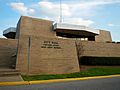
West Point City Hall
-

West Point Post Office (ZIP code: 31833)
-

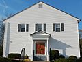
Hawkes Children's Library of West Point was built in 1922 and added to the National Register of Historic Places on December 28, 1990.
-
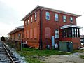
West Point Freight Depot was built in 1887 and added to the National Register of Historic Places on February 24, 2005.
-

West Point Public School was added to the National Register of Historic Places on April 1, 1999.
-

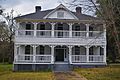
White Hall is a Greek Revival-style plantation home built in 1857 and added to the National Register of Historic Places on August 19, 1974.
-
Long Cane Historic District was added to the National Register of Historic Places on May 24, 1976.
-

Westside Historic District was added to the National Register of Historic Places on May 11, 2011.
-
The Henry and Lura Miller House was added to the National Register of Historic Places on December 21, 2020.

.JPG)

_Freight_Depot.JPG)


See also
 In Spanish: West Point (Georgia) para niños
