
Willamette Valley (ecoregion) facts for kids
Quick facts for kids Willamette Valley |
|
|---|---|

Wetlands near Eugene, Oregon
|
|

Willamette Valley ecoregion (3)
|
|
| Ecology | |
| Realm | Nearctic |
| Biome | Temperate broadleaf and mixed forests |
| Borders | Cascades, Coast Range, Klamath Mountains and Puget lowland forests |
| Bird species | 177 |
| Mammal species | 77 |
| Geography | |
| Area | 14,900 km2 (5,800 sq mi) |
| Country | United States |
| States | Washington and Oregon |
| Coordinates | 44°48′N 123°12′W / 44.8°N 123.2°W |
| Conservation | |
| Habitat loss | 65.679% |
| Protected | 4.07% |
The Willamette Valley ecoregion is a special natural area in Oregon and Washington. An ecoregion is a large area of land or water that has its own unique mix of plants, animals, and ecosystems. This ecoregion is a bit bigger than the famous Willamette Valley itself.
It includes the flat lands and riverbanks of the Willamette River system. You'll also find scattered hills, small mountains called buttes, and nearby foothills. This area is different from the Coast Range, Cascades, and Klamath Mountains ecoregions. It gets less rain, is lower in elevation, and has a different mix of plants.
On average, it rains about 37 to 60 inches (96 to 152 cm) each year. Summers are usually dry. Long ago, this region had rolling grasslands, oak savannas (grasslands with scattered oak trees), conifer forests, many wetlands, and forests along rivers. Today, most of Oregon's people, businesses, and farms are in this ecoregion. Its rich soils and mild weather make it one of Oregon's most important farming areas.
Contents
Exploring the Willamette Valley Ecoregion
This ecoregion covers about 5,753 square miles (14,900 square kilometers). Most of it is in Oregon, with a small part crossing the Columbia River into southern Washington. The ecoregion sits in the Willamette Valley, which stretches from south to north. It's located between the Oregon Coast Range to the west and the Cascades Range to the east. The Willamette River and its smaller rivers drain most of this area. The Willamette River flows into the Columbia River near Portland, Oregon.
Plants and Animals of the Willamette Valley


In the past, the Willamette Valley mostly had oak savannas. These were tall grasslands with scattered Garry oak trees and groups of coast Douglas-fir trees. Along the rivers, there were many wetlands and forests with willow, alder, and cottonwood trees.
Native American groups used to set fires often in the valley. These fires helped keep the grasslands open and stopped young trees from growing too much. When American settlers arrived in the 1800s, they stopped these fires. They also turned much of the valley into farmland. This caused many of the old grasslands and savannas to become thick forests.
Sadly, less than one-tenth of one percent of the original savanna plants are left. A small part of the Garry oak savanna is protected at Mount Pisgah Arboretum in Eugene.
Different Parts of the Willamette Valley Ecoregion

The Willamette Valley ecoregion is divided into four smaller areas. Each has its own unique features.
Portland/Vancouver Basin (3a)
The Portland/Vancouver Basin is a low area of land named after the cities of Portland and Vancouver. It's where the Willamette and Columbia Rivers meet. This area has sands and gravels left behind by ancient floods, like the huge Missoula Floods. The land here is mostly flat, from 0 to 300 feet (0 to 90 meters) high, with some small hills up to 650 feet (200 meters).
Historically, this basin had Garry oak and Douglas-fir forests on higher ground. Along the rivers, there were black cottonwood trees. In wet areas, you'd find Oregon ash, red alder, and western redcedar. There were also open grasslands kept clear by Native American burning. These grasslands had plants like camas, sedges, tufted hairgrass, and California oatgrass.
Today, many wetlands and ponds still exist. However, the area is now mostly cities, towns, farms, and tree farms. The weather is usually mild, but strong easterly winds from the Columbia River Gorge can sometimes bring very hot or cold temperatures. This area covers about 305 square miles (790 square kilometers) in Washington and 269 square miles (697 square kilometers) in Oregon. It includes parts of the Portland area. Several wildlife refuges, like the Ridgefield National Wildlife Refuge Complex, are found here.
Willamette River and Tributaries Gallery Forest (3b)
The Willamette River and Tributaries Gallery Forest ecoregion includes the slow-moving, winding channels of the Willamette River and its smaller rivers. It also has oxbow lakes (U-shaped lakes formed when a river changes course) and old river scars on the wide floodplains. The elevation here ranges from 40 to 500 feet (12 to 150 meters).
This region used to be the natural floodplains of the Willamette River system. However, dams built upstream now control floods, which has changed the river's natural flow. This has also affected the rare and endangered Oregon chub fish. A small part of the floodplain, called the Willamette Floodplain, is protected within the William L. Finley National Wildlife Refuge.
Historically, forests grew along the rivers here. These "gallery forests" had ash, black cottonwood, alder, and bigleaf maple trees. They grew on rich, fertile soils. Today, most of these forests have been replaced by farms and homes. This area covers about 675 square miles (1,748 square kilometers) in Oregon. It forms a narrow strip along almost the entire length of the Willamette River and the lower parts of its tributaries like the McKenzie, Santiam, and Tualatin rivers. The Tualatin River National Wildlife Refuge is also in this area.
Prairie Terraces (3c)

The Prairie Terraces ecoregion includes all the flat, raised areas (terraces) of the Willamette River upstream from the Portland/Vancouver Basin. It has slow-moving, winding streams and rivers. The elevation here is between 160 and 500 feet (50 to 150 meters).
These wide terraces once had oak savannas and prairies. You would find Garry oak trees and plants like camas, sedges, tufted hairgrass, and California oatgrass. Wetter areas supported Oregon ash, Douglas-fir, bigleaf maple, and black cottonwood trees. Underneath, there were plants like poison-oak, hazel, and Indian plum. Some Ponderosa pine trees grew in the south.
Today, only small patches of the original native prairie remain. The soils here don't drain well, especially those from old glacial lake deposits. Because of this, farmers mostly grow grass seed and small grains, as these crops handle wet conditions better. In the past, seasonal wetlands and ponds were common. Now, many streams have been straightened, and wetlands have been drained for farming. Besides agriculture, the Prairie Terraces have seen a lot of city and town growth along the Interstate 5 highway. This region covers about 1,971 square miles (5,105 square kilometers) in Oregon. It includes the Baskett Slough and Ankeny national wildlife refuges.
Valley Foothills (3d)
The Valley Foothills ecoregion is a transition zone. It sits between the farmlands of the Willamette Valley and the denser forests of the Cascade and Coast ranges. This area has rolling hills with winding streams and a few small mountains, reaching about 1,500 feet (457 meters) high. It gets less rain than the nearby mountains, so its natural plant life is different.
The eastern foothills are wetter than those on the western side of the valley, which are in the rain shadow of the Coast Range. Historically, drier areas had Garry oak and madrone woodlands and prairies. These prairies had plants like California oatgrass, fescue, blue wildrye, and other wildflowers. Moister areas had Douglas-fir forests with plants like sword fern, oceanspray, hazel, baldhip rose, poison oak, and wild blackberry.
Today, the valley foothills are home to rural houses, pastures, timber forests, vineyards, Christmas tree farms, and orchards. This is the largest of the Willamette Valley subregions. It covers about 2,415 square miles (6,255 square kilometers) in Oregon and 112 square miles (290 square kilometers) in Washington.
Images for kids
-
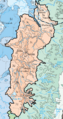
Level IV ecoregions in the Willamette Valley. (Full map).
