
Yates County, New York facts for kids
Quick facts for kids
Yates County
|
||
|---|---|---|

Yates County Courthouse
|
||
|
||

Location within the U.S. state of New York
|
||
 New York's location within the U.S. |
||
| Country | ||
| State | ||
| Founded | February 5, 1823 | |
| Named for | Joseph C. Yates | |
| Seat | Penn Yan | |
| Largest village | Penn Yan | |
| Area | ||
| • Total | 376 sq mi (970 km2) | |
| • Land | 338 sq mi (880 km2) | |
| • Water | 38 sq mi (100 km2) 10% | |
| Population
(2020)
|
||
| • Total | 24,774 | |
| • Density | 73.3/sq mi (28.3/km2) | |
| Time zone | UTC−5 (Eastern) | |
| • Summer (DST) | UTC−4 (EDT) | |
| Congressional district | 23rd | |

Yates County is a county located in the state of New York. In 2020, about 24,774 people lived here. This makes it one of the least populated counties in New York. The main town, or county seat, is Penn Yan. The county is named after Joseph C. Yates. He was the Governor of New York who signed the law to create the county. Yates County is part of the beautiful Finger Lakes region. It is also included in the larger Rochester Metropolitan Area.
Contents
History of Yates County
When New York State first created counties in 1683, the area that is now Yates County was part of a huge place called Albany County. This county was enormous! It stretched across New York and even included parts of what is now Vermont. It was even thought to go all the way to the Pacific Ocean.
Over many years, Albany County was made smaller. In 1772, it was split into three parts. One new part was called Tryon County. This western part was named after William Tryon, who was the British governor at the time.
After the American Revolutionary War ended in 1784, the name of Tryon County was changed. It became Montgomery County. This honored Richard Montgomery, an American general who fought bravely in the war.
Later, in 1789, a big piece of Montgomery County was used to create Ontario County. This new county was still very large. It included land that would later become many other counties.
Over the next few years, Ontario County was also divided several times. New counties like Steuben and Genesee were formed from its land.
Finally, on February 5, 1823, Yates County was officially created. It was formed from about 310 square miles of Ontario County. This new area included towns like Penn Yan and Middlesex. A few years later, in 1826, a small part of Steuben County was added to Yates County. This brought towns like Dundee into Yates County. The county's borders were finalized in 1946.
In 1974, a new group of Mennonite people started living in Yates County. This community has grown a lot since then. By 2015, more than 3,000 Mennonites lived there.
Geography of Yates County
Yates County is located in the western part of New York State. It is northwest of Ithaca and southeast of Rochester. The county is famous for being in the beautiful Finger Lakes Region.
The total area of Yates County is about 376 square miles. Most of this (338 square miles) is land. The rest (38 square miles, or 10%) is water.
Neighboring Counties
- Ontario County - to the northwest
- Seneca County - to the east
- Schuyler County - to the south
- Steuben County - to the southwest
People of Yates County
| Historical population | |||
|---|---|---|---|
| Census | Pop. | %± | |
| 1830 | 19,009 | — | |
| 1840 | 20,444 | 7.5% | |
| 1850 | 20,590 | 0.7% | |
| 1860 | 20,290 | −1.5% | |
| 1870 | 19,595 | −3.4% | |
| 1880 | 21,087 | 7.6% | |
| 1890 | 21,001 | −0.4% | |
| 1900 | 20,318 | −3.3% | |
| 1910 | 18,642 | −8.2% | |
| 1920 | 16,641 | −10.7% | |
| 1930 | 16,848 | 1.2% | |
| 1940 | 16,381 | −2.8% | |
| 1950 | 17,615 | 7.5% | |
| 1960 | 18,614 | 5.7% | |
| 1970 | 19,831 | 6.5% | |
| 1980 | 21,459 | 8.2% | |
| 1990 | 22,810 | 6.3% | |
| 2000 | 24,621 | 7.9% | |
| 2010 | 25,348 | 3.0% | |
| 2020 | 24,774 | −2.3% | |
| U.S. Decennial Census 1790-1960 1900-1990 1990-2000 2010-2020 |
|||
In 2000, there were 24,621 people living in Yates County. The population density was about 73 people for every square mile. Most people (97.90%) were White. There were also smaller groups of African American, Native American, and Asian people. About 0.93% of the population was Hispanic or Latino.
Many people in Yates County have roots from different countries. Some common backgrounds include English, German, Irish, and Italian.
A special thing about Yates County is that many people speak Pennsylvania Dutch, German, or Dutch at home. This is mostly the Wenger Old Order Mennonites. About 5.46% of people over 5 years old speak these languages.
The county has many families. In 2000, about 31.50% of households had children under 18. The average household had about 2.59 people. The median age was 38 years old.
2020 Census Information
| Race | Num. | Perc. |
|---|---|---|
| White (NH) | 23,049 | 93.04% |
| Black or African American (NH) | 145 | 0.6% |
| Native American (NH) | 28 | 0.11% |
| Asian (NH) | 93 | 0.4% |
| Pacific Islander (NH) | 8 | 0.03% |
| Other/Mixed (NH) | 777 | 3.14% |
| Hispanic or Latino | 674 | 2.72% |
Education in Yates County
Keuka College is a college located in Yates County.
Transportation in Yates County
Yates County has two public airports. The main one is Penn Yan Airport (PEO). It is located on a hill south of Penn Yan. There is also Middlesex Valley Airport (4N2) in Middlesex.
The Yates Transit Service provides bus service for people in the county. The county's Highway Department helps keep the roads in good shape. They oversee road building and repairs. They also help with snow and ice removal. Each town and village in Yates County has its own highway department too.
Main Roads
 New York State Route 14
 New York State Route 14A
 New York State Route 21
 New York State Route 54
 New York State Route 54A
 New York State Route 230
 New York State Route 245
 New York State Route 247
 New York State Route 364
- List of county routes in Yates County, New York
Communities in Yates County
| # | Location | Population | Type |
|---|---|---|---|
| 1 | †Penn Yan | 5,159 | Village |
| 2 | Dundee | 1,725 | Village |
| 3 | Keuka Park | 1,137 | CDP |
| 4 | ‡Rushville | 655 | Village |
| 5 | Dresden | 308 | Village |
† - County Seat
‡ - Not Wholly in this county
Towns in Yates County
Hamlets in Yates County
- Bellona
- Branchport
- Glenora
- Himrod
- Lakemont
- Rock Stream
- Potter Center, New York
- Middlesex, New York
Images for kids
-
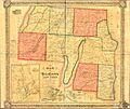
Historical Map of Yates County, 1855

See also
 In Spanish: Condado de Yates para niños
