
Afon Clun facts for kids
Quick facts for kids Afon Clun |
|
|---|---|

The Afon Clun near Talbot Green
|
|
| Country | Wales |
| Physical characteristics | |
| Main source | The Garth (Mynydd y Garth), City and County of Cardiff 260 m (850 ft) 51°32′30″N 3°18′10″W / 51.54167°N 3.30278°W |
| River mouth | River Ely (Afon Elái), Pontyclun, Rhondda Cynon Taf 42 m (138 ft) 51°31′38.35″N 3°23′26″W / 51.5273194°N 3.39056°W |
| Length | 23 km (14 mi) |
| Basin features | |
| Basin size | 32 km2 (12 sq mi) |
| Tributaries |
|
The Afon Clun (which means River Clun in English) is a river in Wales. It flows for about 14 miles (23 km). This river is a tributary of the River Ely. You can find it in the areas of Cardiff and Rhondda Cynon Taf.
The river starts on the western side of The Garth. It flows quickly over clear, shallow water. The riverbed is mostly made of hard rock like sandstone. The Afon Clun flows south of Llantrisant and then generally west. It joins the River Ely at Pontyclun. Along its journey, the river drops about 715 feet (218 meters).
The Afon Clun is home to many fish species. These include stone loach, lamprey, eel, roach, chub, and bullhead. The valley around the river is also full of wildlife. You might see dragonflies and damselflies. Other animals include badgers, marsh fritillary butterflies, bats, dormice, otters, and great crested newts. Some of these, like bats and otters, are special protected species in Europe. Birds like bullfinches, kingfishers, and skylarks also live here.
Sometimes, the valley between Cross Inn and Pontyclun can flood. The river might overflow its northern bank. This happens for about 1.5 miles (2.4 km) downstream from the main A4119 road at Talbot Green. When it floods, it creates a wetland habitat. This is a special place for wildlife.
Many old sites are found near the river. These include Bronze Age burial mounds (called tumuli) on The Garth. There's also an Iron Age hill fort at Rhiwsaeson. More recently, there are signs of old coal mines from the industrial past.
Contents
Journey of the Afon Clun

The Afon Clun is a main tributary of the River Ely. It drains an area of about 12 square miles (32 square kilometers). This area is in south Wales, northwest of Cardiff. The river's source is on the western side of The Garth. This mountain is about 1,007 feet (307 meters) high. It's made of sandstone. The Garth is located between Cardiff and Pontypridd. Its eastern side feeds the River Taff.
The Garth is in the northwest part of the City and County of Cardiff. It's above the village of Gwaelod y Garth. This is about 7 miles (11 km) northwest of Cardiff city center. The lower northern slopes of The Garth mark the border with Rhondda Cynon Taf. This is about half a mile (800 m) north of where the Clun starts. The land drops sharply on the eastern side of The Garth. However, the drop is less steep on the western slopes, where the Clun begins.
The river still falls to about 165 feet (50 meters) by the time it reaches Rhiwsaeson. This is just under 2 miles (3 km) from its source. The Afon Clun flows fast. Its water is clear and shallow. The riverbed is hard, made of gravel, cobble, and pebbles.

Near the Dŵr Cymru/Welsh Water plant at Rhiwsaeson, another stream joins the Afon Clun. This is Nant Myddlyn, which flows from the north. Nant Myddlyn itself is joined by Nant Dowlais from the east. Nant Myddlyn starts in Tynant, Beddau. Nant Dowlais begins in Church Village.
After leaving Rhiwsaeson, the Clun gets wider and slows down. It flows south of Cross Inn. Here, and along Nant Dowlais and Nant Myddlyn, signs of otters have been seen. The river then flows south of the A473 road. Here, Nant Mwyndy joins it from the south. Nant Mwyndy flows over Carboniferous Limestone. It starts in Creigiau and flows west. It passes a small industrial area and a lake. This lake was formed from old Victorian opencast iron mining.
The Clun then flows under the main A4119 road near Talbot Green. At this spot, the river often overflows onto the nearby meadows. This creates a wetland habitat for wildlife. However, building houses and roads has reduced these important wetland areas. To the south, the Coed-yr-Hendy woodland follows the river for its last half-mile (800 m). This woodland's gentle slope helps prevent flooding on the river's southern bank.
The Clun passes Y Pant Comprehensive School and Pontyclun Fire Station. It then flows under a bridge for the A4222 road. The nearby village, Pontyclun, means "Clun bridge." Just past this bridge, the Afon Clun joins the River Ely. This is about 14 miles (23 km) from its source. The River Ely then flows south towards Cardiff. It eventually reaches Cardiff Bay and then the Bristol Channel.
Villages in the Clun Valley
The Afon Clun and its smaller streams flow through several towns and villages. These are all within Rhondda Cynon Taf. They are:
- Efail Isaf
- Tonteg
- Church Village
- Llantwit Fardre
- Beddau
- Rhiwsaeson (Llantrisant)
- Groes-faen
- Cross Inn (Llantrisant)
- Talbot Green
- Tyla Garw (Pontyclun)
- Pontyclun
River Life and Environment
The area around the Afon Clun gets a lot of rain, about 73.9 inches (1,877 mm) each year. The ground beneath the river is mostly sandstone.
The water quality of the Afon Clun is generally good. It's usually rated as RE2 or better.
- RE1 means 'Water of very good quality suitable for all fish species'.
- RE2 means 'Water of good quality suitable for all fish species'.
- RE3 means 'Water of fair quality suitable for high class coarse fish populations'.
- RE4 means 'Water of fair quality suitable for coarse fish populations'.
- RE5 means 'Water of poor quality which is likely to limit coarse fish populations'.
The Afon Clun and its streams are special "salmonid waters and cyprinid waters." This means they are protected to help fish populations thrive.
The local council, Rhondda Cynon Taf (RCT), has named the Afon Clun Valley and Rhiwsaeson Hill as a "Site of Important Nature Conservation." This helps protect the area from too much building. RCT has also marked other undeveloped areas along the river as "Special Landscape Areas (SLAs)." These areas are protected for their beautiful scenery. They are considered when new buildings are planned.
River Animals and Plants

The Afon Clun and Nant Dowlais have many small fish. These include minnows, sticklebacks, stone loach, lamprey, and eel. You can also find roach and chub here.
In the flood-meadows next to the river, you might see beautiful common orchids. The riverbanks have broadleaf trees. But there are also some plants that don't belong, like Himalayan balsam and Japanese knotweed. These can take over from native plants.
Many types of dragonfly and damselfly fly over the river. Other animals living here are bats, badgers, dormice, otters, and great crested newts. Bats, dormice, otters, and great crested newts are special protected species in Europe. Otters have been seen using Nant Dowlais and Nant Myddlyn. Several types of bats, like Natterer's and pipistrelle, have been seen in the area.
The Clun flows through areas important for wildlife. Birds that are a "conservation concern" have been seen here. These include bullfinch, kingfisher, linnet, reed bunting, skylark, and song thrush.
The hedgerows (lines of bushes) in the area are also protected. They are important for wildlife.
Farmers keep animals like horses and sheep in fields near the river. Farmers are encouraged to fence off the river. This stops animals from causing erosion. It also prevents chemicals used for sheep from getting into the water.
River and Industry
Some companies near the Afon Clun valley follow special rules. These rules, called Integrated Pollution Control (IPC), help reduce pollution. For example, Nipa Laboratories makes chemicals, and Maxibrite makes smokeless fuels. These rules make sure companies use the "Best Available Techniques Not Entailing Excessive Cost" (BATNEEC). This means they must try their best to prevent pollution.
After coal mining stopped in south Wales, the Afon Clun started to get cleaner. It returned to how it was before the Industrial Revolution. However, there have been some pollution incidents since then. In 2000, a chemical spill into Mwyndy Brook harmed many fish and eels in the Clun. The company responsible worked to fix the problem.
From 1994 to 1996, the water quality in Nant Myddlyn was poor (RE5). This was due to waste from the Cwm Coke Works. After a new treatment plant was built, the water quality improved to good (RE2). The works closed in 2002.
Since the Cwm Coking Works closed, less water is taken from the Afon Clun area. The works used to take a lot of water. Sometimes, this caused Nant Myddlyn to dry up.
River Floodplain

Upstream, the river has steep slopes and shallow soil. About 18% of the area around the river is urban. Because there is also a lot of rain, the area can flood quickly. Flooding also happens when the River Ely's water levels are high.
Flat land next to rivers is often attractive for building. Over the last 20 years, parts of the floodplain between Cross Inn and Pontyclun have been built on. This means there is less space for the river to overflow naturally. Roads, shops, schools, and houses have been built where floodwaters used to go. Some old flood defenses are now part of people's gardens. Y Pant School was built on the floodplain, even though it was advised against.
Today, authorities see the floodplain as a key part of the river system. It's important to keep it free from new buildings to help with flood defense. The Clun often overflows its northern bank for about 1.5 miles (2.4 km). This floodplain creates a wetland habitat for wildlife. Horses are also kept in these meadows when they are not too wet.
A Glimpse into the Past
After the last ice age, about 12,000 to 10,000 years ago, early people came to Great Britain. They were hunter-gatherers from Central Europe. They could walk across dry land that connected Europe and Britain. Later, around 8,000 years ago, the sea level rose. People then came to Wales by boat from places like Spain. These new settlers mixed with the local people. Over time, people changed from hunting and gathering to farming. They cleared forests to create fields for crops and animals.
Later, new people and ideas from the Bronze Age and Iron Age Celtic cultures arrived. The Afon Clun Valley was settled by a Celtic tribe called the Silures. This tribe lived in the areas now known as Brecknockshire, Monmouthshire, and Glamorgan.
Bronze Age Discoveries
Near the river's source, at the top of The Garth, there are five round barrows. These are ancient burial mounds. They are thought to be from the Bronze Age. One of them even has a trig. pillar (a surveying marker) on its flat top.
Iron Age Hillfort
Overlooking the Clun at Rhiwsaeson is Caerau hillfort. This is an oval Iron Age enclosure. It measures about 755 feet (230 meters) from east to west and 590 feet (180 meters) across. It dates back to 700 BCE. It is one of the largest hill forts in south Wales. The fort had two banks and ditches for defense. The main bank was once about 25 feet (7.6 meters) high. The entrance to the fort was about 25 feet (7.6 meters) wide.
Tudor Iron Making
Lead mines opened in Mwyndy in 1531. By August 1531, iron ore was also being mined there. Iron smelting (melting ore to get metal) started nearby in 1532. There was a furnace at Mwyndy and maybe a smaller one at Rhiwsaeson. Workers produced iron blooms, which were lumps of iron. They used charcoal from local forests to heat the furnaces. The iron mines were leased by the king in 1539. There is no sign that iron mining continued here after the 16th century.
The name Mwyndy likely comes from Welsh words: mwyn meaning "mine" and dŷ (a changed form of tŷ) meaning "house."
The mine was reopened around 1859. Over one million tons of iron ore were mined at Mwyndy before it closed in 1884. The lake that formed from these old workings now feeds into Nant Mwyndy.
Coal Mining History
The Afon Clun marks the southern edge of the South Wales Coalfield. There were several old collieries (coal mines) north of the river. Many pits opened in the 1860s. Cwm Colliery opened in 1909, leading to a big increase in people living there. In 1923, the Ynysmaerdy Colliery opened near Llantrisant.
In 1931, an underground railway linked Cwm Colliery to another mine. By 1934, Cwm Colliery employed many workers. On June 2, 1941, a methane gas explosion at Cwm Colliery killed four men. It also destroyed most of the buildings above ground. The mine never reopened after this accident.
The mines became government-owned in 1947. In 1957, another underground railway linked Cwm Colliery with Coedely Colliery. This made them the largest coal mine in south Wales. At its busiest in 1960, Cwm Colliery employed 1,470 men. It produced a huge amount of coal. British Coal closed Cwm Colliery in 1986.
Ffordd-y-Bryniau Walk
Ffordd-y-Bryniau is a 21-mile (34 km) ridgeway walk. It goes through Taff-Ely. The walk starts in the west at Mynydd Maendy and ends in the east at Caerphilly Mountain. The path goes through Llantrisant Forest, Llantrisant Town, and Caerau Hillfort. It only leaves the ridgeway at the Ely Valley and Nant Myddlyn. The path is marked with yellow and black discs showing hills.
This route connects with other walks. These include the Ogwr Ridgeway Walk, the Coed Morgannwg Way, the Taff Trail, and the Rhymney Valley Ridgeway Walk.
Future Plans
Improvements to the road network, especially the A4119, have brought more development to the area around Llantrisant. Many new houses have been built in villages along the A473 road. This road runs parallel to the Afon Clun. More building has put pressure on the roads. This led to plans for the Church Village bypass being brought back. Work on the bypass started in 2008.
Studies have been done to make sure the bypass causes the least harm to nature. These studies found bats, badgers, dormice, otters, great crested newts, and marsh fritillary butterflies in the area.
There is also a plan to make the A473 Talbot Green Bypass a dual carriageway. This plan depends on how much building happens in the area.
A single railway track runs north from Pontyclun station. It turns west at Talbot Green and runs alongside the A473. The track used to go to the Cwm Coking Works. All the old railway equipment is still there between Talbot Green and Pontyclun. This includes the track, signals, and bridges. A recent study looked into reopening this railway line for passengers. This would mean new stations at Talbot Green, Llantrisant, Gwaun Meisgyn, and Beddau.
Images for kids
-
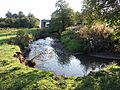
The Afon Clun near Talbot Green
-
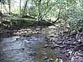
Nant Myddlyn at Llantwit Fardre
-
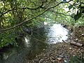
The Afon Clun at Rhiwsaeson
-
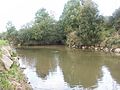
Confluence of Ely (left/north) and Afon Clun (right/east), at Pontyclun
-
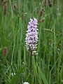
Common orchid by the Afon Clun at Talbot Green
-
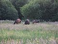
The flood-meadow north of the Afon Clun at Talbot Green

