Agawam, Massachusetts facts for kids
Quick facts for kids
Agawam, Massachusetts
|
|||
|---|---|---|---|
| Town of Agawam[*] | |||
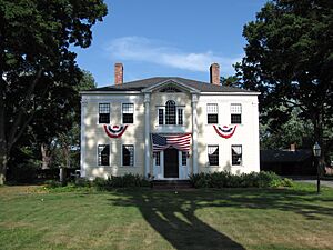
Capt. Charles Leonard's house
|
|||
|
|||
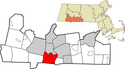
Location in Hampden County in Massachusetts
|
|||
| Country | United States | ||
| State | Massachusetts | ||
| County | Hampden | ||
| Settled | May 15, 1636 | ||
| Incorporated (town) | May 17, 1855 | ||
| Incorporated (city) | January 1, 1973 | ||
| Government | |||
| • Type | Mayor-council city | ||
| Area | |||
| • Total | 24.34 sq mi (63.03 km2) | ||
| • Land | 23.32 sq mi (60.40 km2) | ||
| • Water | 1.01 sq mi (2.62 km2) | ||
| Elevation | 90 ft (27 m) | ||
| Population
(2020)
|
|||
| • Total | 28,692 | ||
| • Density | 1,230.25/sq mi (475.01/km2) | ||
| Time zone | UTC−5 (Eastern) | ||
| • Summer (DST) | UTC−4 (Eastern) | ||
| ZIP code |
01001
|
||
| Area code(s) | 413 | ||
| FIPS code | 25-00840 | ||
| GNIS feature ID | 0608970 | ||
Agawam is a city in Hampden County, Massachusetts, United States. It's home to about 28,692 people, based on the 2020 census. Agawam is located on the west side of the Connecticut River, right across from Springfield. It's part of the larger Springfield area, which is the second-biggest metropolitan area in New England. A part of Agawam is called Feeding Hills. One of the most exciting places in Agawam is Six Flags New England, a big amusement park right by the Connecticut River.
Did you know that Agawam's ZIP code, 01001, is the lowest in the entire contiguous United States?
Contents
- What's in a Name? The Meaning of Agawam
- Agawam's Past: A Look at Its History
- Agawam's Location and Natural Beauty
- Who Lives in Agawam? Demographics
- Businesses and Fun Places in Agawam's History
- Agawam's Library System
- Schools in Agawam
- Fun Places to Visit in Agawam
- Famous People from Agawam
- See also
What's in a Name? The Meaning of Agawam
The name "Agawam" comes from the Native American village that was once here. It was known by many similar names like Agawanus or Aggawom. People think the name might mean "unloading place" or "fish-curing place." This could be because people would unload fish from canoes at Agawam Falls to prepare them on the nearby river flats.
Another town, Ipswich, was also called Agawam a long time ago. This was named after the Agawam tribe, who were the original people living in that area.
Agawam's Past: A Look at Its History
How Agawam Started
On May 15, 1636, a man named William Pynchon bought land from the local Pocomtuc Native Americans. This land was on both sides of the Connecticut River. It included what we now know as Agawam, Springfield, and other nearby towns. He bought the Agawam part for 10 coats, 10 hoes, 10 hatchets, 10 knives, and 10 fathoms of wampum (a type of shell bead).
Agawam and West Springfield used to be one area. They separated from Springfield in 1757. Then, Agawam and West Springfield split into two different towns in 1800. Agawam officially became a town on May 17, 1855.
Old Businesses and Buildings
In 1771, John Porter started a gin distillery in Agawam. His grandson, Harry, later took over the business. The company was sold in 1917. During a time called Prohibition, when alcohol was illegal, the building made potato chips and cider instead. After Prohibition ended, it made gin again but closed for good in 1938. The building later became a garage for the town's public works department.
Agawam sent 172 men to fight in the American Civil War. Sadly, 22 of them died during the war.
The first town hall was built in 1874. It held the town government offices and the town library. A small school for younger students was also nearby. This building was taken down in 1938. Now, Benjamin Phelps Elementary School is on that spot.
Another town hall in Feeding Hills was built in 1906. It looked very similar to the Agawam town hall. It was taken down in 1950 to make way for the Clifford M. Granger Elementary School, which opened in 1946.
Bowles Agawam Airport
In the early 1930s, the Bowles Agawam Airport had its grand opening. In 1931, about 100 biplanes from the United States Army Air Corps even visited! A regular air service operated from the airport for about a year. The airport continued to be used for civil flights until 1982.
Next to the airport, there was a horse racing track. A famous horse named Seabiscuit even won a race there in 1935! The racetrack closed in 1938. In the late 1980s, both the airport and racetrack were taken down. Now, the area is an industrial park.
Agawam's Location and Natural Beauty
Agawam is located at 42°4′19″N 72°38′39″W / 42.07194°N 72.64417°W. It shares borders with several towns. To the north is West Springfield. To the west is Southwick. To the east is Longmeadow. Springfield is to the northeast, and Suffield, Connecticut, is to the south. Westfield is also nearby to the northwest.
The city covers about 24.2 square miles. Most of this is land (23.2 square miles), and about 1 square mile is water.
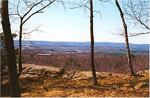
The highest point in Agawam is Provin Mountain, which is about 640 feet tall. This mountain, along with part of East Mountain, forms the western edge of the city. These mountains are part of the Metacomet Ridge, a long line of rocky hills that stretches through New England. You can hike on the Metacomet-Monadnock Trail along these ridges.
As mentioned before, Agawam has a part called Feeding Hills. It's located near the borders of Southwick, Westfield, and Suffield.
Who Lives in Agawam? Demographics
| Historical population | ||
|---|---|---|
| Year | Pop. | ±% |
| 1860 | 1,698 | — |
| 1870 | 2,001 | +17.8% |
| 1880 | 2,216 | +10.7% |
| 1890 | 2,352 | +6.1% |
| 1900 | 2,536 | +7.8% |
| 1910 | 3,501 | +38.1% |
| 1920 | 5,023 | +43.5% |
| 1930 | 7,095 | +41.3% |
| 1940 | 7,842 | +10.5% |
| 1950 | 10,166 | +29.6% |
| 1960 | 15,718 | +54.6% |
| 1970 | 21,717 | +38.2% |
| 1980 | 26,271 | +21.0% |
| 1990 | 27,323 | +4.0% |
| 2000 | 28,144 | +3.0% |
| 2010 | 28,438 | +1.0% |
| 2020 | 28,692 | +0.9% |
| 2022* | 28,393 | −1.0% |
| * = population estimate. Source: United States Census records and Population Estimates Program data. Source: |
||
In 2010, there were about 28,144 people living in Agawam. There were 11,260 households, which are groups of people living together.
About 28.9% of households had children under 18. The average household had 2.43 people. The average family had 3.01 people.
The median age in the city was 40 years old. This means half the people were younger than 40, and half were older. About 22.1% of the population was under 18.
Businesses and Fun Places in Agawam's History
Early Businesses
- 1801: An early peppermint distillery started, which later became known for "Agawam Gin."
- 1810: A cotton mill was built where Six Flags New England is today.
- 1812: The Agawam Woolen Mill opened. After a fire, it was rebuilt in brick in 1889 and is still standing. It closed in 1949.
Six Flags New England
Six Flags New England is a very popular amusement park. It started as a picnic area way back in 1840! It became a full amusement park in 1940. From 1948 to 2000, it also had a NASCAR racing track called Riverside Park Speedway. Six Flags bought the park in 1996.
Other Businesses
- 1952: Stacy Machine Co. opened a new factory. They were known for making special printing presses. The factory closed in the 1990s, but the building is still there.
- 1953: WWLP, a TV station, started broadcasting from Provin Mountain in Feeding Hills.
Agawam's Library System
The Agawam Free Public Library first opened in 1891. The first libraries were small rooms in the Agawam and Feeding Hills town halls. After a fire destroyed a school and its books in 1904, Fred P. Halladay donated land for a new library in North Agawam. In 1925, Minerva Porter Davis donated a building for the library in Agawam Center.
The Feeding Hills library moved to a new building when the old town hall was taken down. In 1978, all the libraries were combined into one new building next to the High School.
Schools in Agawam
Agawam has several schools for students of all ages:
- Benjamin J. Phelps Elementary School (Kindergarten to 4th grade)
- Clifford M. Granger Elementary School (Kindergarten to 4th grade)
- James Clark Elementary School (Kindergarten to 4th grade)
- Robinson Park Elementary School (Kindergarten to 4th grade)
- Roberta G. Doering Middle School (5th to 6th grade)
- Agawam Junior High School (7th to 8th grade)
- Agawam High School (9th to 12th grade)
Fun Places to Visit in Agawam
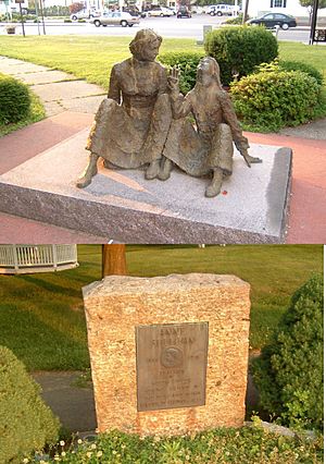
- Agawam Historical Association: You can visit the Agawam Historical and Fire House Museum. They also have the historic Thomas Smith House.
- Anne Sullivan Memorial: This memorial includes a marker and a statue dedicated to Anne Sullivan. She was the famous tutor of Helen Keller and was born in Feeding Hills.
- Massachusetts Veteran's Memorial Cemetery: This is a special place to honor veterans.
- War Memorial Plaques: At Benjamin J. Phelps Elementary School, you can see plaques with the names of Agawam citizens who died in various wars.
- Metacomet-Monadnock Trail: This long hiking trail goes through the mountains in western Agawam, offering great views.
- Robinson State Park: This large park is great for outdoor activities. Its entrance is on North Street.
- Six Flags New England: Don't forget the biggest amusement park in New England is right here in Agawam!
Famous People from Agawam
- Creighton Abrams: A general who led military operations in the Vietnam War.
- Carl Beane: The voice of the Boston Red Sox baseball team.
- Scott Daniels: A Canadian hockey player who played in the NHL.
- Roger LeClerc: A football player for the Chicago Bears.
- Mike Martin: A basketball head coach for Brown University.
- Phil McGeoghan: A football player and assistant coach for the Los Angeles Chargers.
- Earl Seibert: A hockey player who is in the Hockey Hall of Fame.
- Eddie Shore: Another hockey player in the Hockey Hall of Fame and former owner of the Springfield Indians.
- Anne Sullivan: The famous tutor of Helen Keller.
- Tom Wlaschiha: A German actor known for Game of Thrones and Stranger Things.
See also
 In Spanish: Agawam para niños
 | Laphonza Butler |
 | Daisy Bates |
 | Elizabeth Piper Ensley |


