
Valle d'Aosta facts for kids
Quick facts for kids
Aosta Valley
Valle d'Aosta - Vallée d'Aoste
|
|||
|---|---|---|---|
|
|||
 |
|||
| Country | Italy | ||
| Capital | Aosta | ||
| Area | |||
| • Total | 3,260.90 km2 (1,259.04 sq mi) | ||
| Population
(1 January 2017)
|
|||
| • Total | 126,883 | ||
| • Density | 38.91042/km2 (100.7775/sq mi) | ||
| Time zone | UTC+1 (CET) | ||
| • Summer (DST) | UTC+2 (CEST) | ||
| GDP/ Nominal | € 4.3 billion (2010) | ||
| GDP per capita | € 30,300 (2008) | ||
| NUTS Region | ITC (Northwestern Italy) | ||
| Website | www.regione.vda.it | ||


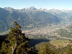
The Valle d'Aosta (also known as Aosta Valley in English) is a beautiful, mountainous region in northwestern Italy. Its official names are Valle d'Aosta in Italian and Vallée d'Aoste in French. The main city and capital of the region is Aosta.
This is the smallest region in Italy. It covers an area of about 3,261 square kilometers (1,259 square miles). About 126,883 people live here. The Aosta Valley is special because it is the only Italian region without provinces. This means the regional government handles all the jobs usually done by a province. The region is divided into 74 smaller areas called comuni.
Contents
Where is Aosta Valley?
The Aosta Valley is surrounded by other countries and regions.
- To the north, it borders Switzerland (specifically the Valais area).
- To the west, it borders France (the Auvergne-Rhône-Alpes region).
- To the south and east, it borders the Italian region of Piedmont.
Amazing Mountains and Valleys
The Aosta Valley is a narrow valley formed by the Dora Baltea river. It's nestled right in the middle of the Alps. This region is famous for being surrounded by four of the tallest mountains in Italy and Europe:
- Mont Blanc: This is the highest mountain in the Alps, standing at about 4,810 meters (15,781 feet) tall.
- Matterhorn (also called Monte Cervino or Mont Cervin): This iconic mountain is about 4,478 meters (14,692 feet) high.
- Monte Rosa: The second highest mountain in the Alps, reaching about 4,634 meters (15,203 feet).
- Gran Paradiso: This mountain is about 4,061 meters (13,323 feet) tall.
Because the Aosta Valley is so mountainous and close to other countries, its mountain passes are very important. These passes are natural routes through the mountains. Even though there are now tunnels, the passes are still important for history, geography, and tourism.
The two main mountain passes connecting the Aosta Valley to other areas are:
- The Little St Bernard Pass: This pass connects the Aosta Valley with Savoie, France.
- The Great St Bernard Pass: This pass connects the Aosta Valley with Valais, Switzerland.
A large part of the southern Aosta Valley is home to the Gran Paradiso National Park. This park was created in 1922 to protect special plants and animals that were in danger of extinction. You can find animals like the Alpine Ibex and Alpine marmot here.
The valleys in this region were carved out by huge glaciers long ago. Today, glaciers are only found on the highest mountain peaks.
The Dora Baltea river flows through the entire Aosta Valley. It starts in the northwest and flows southeast for about 160 kilometers (99 miles). It eventually joins the Po river.
Mountain Communities

All the comuni (except Aosta itself) in the Aosta Valley are grouped into special areas called "mountain communities." There are 8 of these communities:
| Mountain Community | Capital City | Number of Comuni |
|---|---|---|
| Evançon | Verrès | 9 |
| Grand Combin | Gignod | 11 |
| Grand Paradis | Villeneuve | 13 |
| Mont Emilius | Quart | 10 |
| Mont Rose | Pont-Saint-Martin | 9 |
| Monte Cervino | Châtillon | 12 |
| Valdigne Mont Blanc | La Salle | 5 |
| Walser - Alta Valle del Lys | Issime | 4 |
Biggest Towns in Aosta Valley
Here are the 10 comuni in the Aosta Valley with the most people (as of January 2017):
| No. | City | Population (2017) |
Area (km2) |
Density (people/km2) |
Altitude (m) |
|---|---|---|---|---|---|
| 1 | Aosta | 34,361 | 21.39 | 1606.4 | 583 |
| 2 | Sarre | 4,887 | 28.28 | 172.8 | 625 |
| 3 | Châtillon | 4,753 | 39.68 | 119.8 | 549 |
| 4 | Saint-Vincent | 4,620 | 20.57 | 224.6 | 575 |
| 5 | Quart | 4,061 | 62.05 | 65.4 | 535 |
| 6 | Pont-Saint-Martin | 3,833 | 6.92 | 553.9 | 345 |
| 7 | Saint-Christophe | 3,441 | 14.74 | 233.4 | 619 |
| 8 | Gressan | 3,398 | 25.30 | 134.3 | 626 |
| 9 | Saint-Pierre | 3,191 | 26.18 | 121.9 | 676 |
| 10 | Nus | 2,979 | 57.36 | 51.9 | 529 |
People of Aosta Valley
Someone from the Aosta Valley is called a Valdotian.
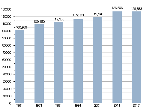
Population Growth
On January 1, 2017, the total population of the Aosta Valley was 126,883 people. This included 61,976 males and 64,907 females.
How the Population of Aosta Valley Has Changed
Languages Spoken
Italian and French are the two official languages of the Aosta Valley. Both are used for government documents and laws. However, Italian is spoken much more often in daily life. About 96% of the people in the valley speak Italian as their first or second language. About 70% speak French as their first or second language. Schools teach equally in both Italian and French.
The local language is a dialect of Franco-Provençal called Valdôtain. Many people (about 58%) speak it as their native language or a second language. In some villages, like Gressoney-Saint-Jean, Gressoney-La-Trinité, and Issime, people speak special dialects of Walser German called Titsch and Töitschu.
Gallery
-
A view of the city of Aosta
-
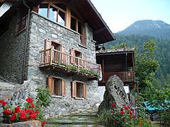
A traditional house in Cretaz, Valtournenche, Aosta Valley.
-
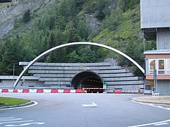
The entrance to the Mont Blanc Tunnel.
-
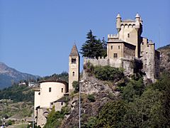
The Saint-Pierre castle.
-
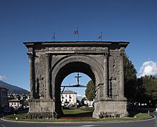
The Arch of Augustus in Aosta.


Images for kids
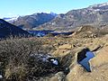
-
A view from refuge Champillon, Valpelline
-
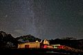
The Astronomical Observatory of the Aosta Valley, in Saint-Barthélemy (Nus).
-
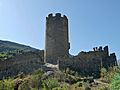
Châtel-Argent
-
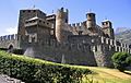
The Fénis Castle, built in the 13th century.
-
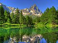
Bleu Lake and the Matterhorn
-
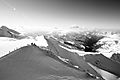
Mount Castor
-
The prehistoric site near Chenal castle, Montjovet, with many ancient rock carvings (petroglyphs).
-
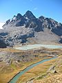
A view from refuge Albert Deffeyes, La Thuile
-
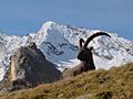
A male Alpine Ibex in Gran Paradiso National Park
-
An Alpine marmot in Gran Paradiso National Park
.jpg)


.jpg)
See also
 In Spanish: Valle de Aosta para niños
