
Barrington, Rhode Island facts for kids
Quick facts for kids
Barrington, Rhode Island
|
||
|---|---|---|

Aerial view of Barrington in 2008
|
||
|
||

Location in Bristol County and the state of Rhode Island.
|
||

Barrington, Rhode Island
Location in Rhode Island

Barrington, Rhode Island
Location in the United States

Barrington, Rhode Island
Location in North America
|
||
| Country | United States | |
| State | Rhode Island | |
| County | Bristol | |
| Settled | 1652 | |
| Incorporation (Massachusetts) | November 18, 1717 | |
| Annexed to Warren | January 27, 1747 | |
| Incorporation (Rhode Island) | June 16, 1770 | |
| Government | ||
| • Type | Council-manager | |
| Area | ||
| • Total | 15.4 sq mi (39.9 km2) | |
| • Land | 8.4 sq mi (21.8 km2) | |
| • Water | 7.0 sq mi (18.1 km2) | |
| Elevation | 0 to 50 ft (0 to 15 m) | |
| Population
(2020)
|
||
| • Total | 17,153 | |
| • Density | 2,038/sq mi (786.8/km2) | |
| Time zone | UTC−5 (Eastern (EST)) | |
| • Summer (DST) | UTC−4 (EDT) | |
| ZIP Code |
02806
|
|
| Area code(s) | 401 | |
| FIPS code | 44-05140 | |
| GNIS feature ID | 1220084 | |

Barrington is a town in Rhode Island, United States. It's a quiet, mostly residential area in Bristol County, Rhode Island, about 7 miles (11 km) southeast of Providence. In 2020, about 17,153 people lived here.
Barrington was started by a group of people from Swansea, Massachusetts, in 1652. It officially became a town in 1717. Later, it became part of Rhode Island in 1747 and then a separate town again in 1770. For a long time, Barrington was a farming community. But in the 1850s, companies that made bricks came to town. Many French-Canadians and Italians moved here to work in these factories. When a railroad to Providence was built in 1855, more people moved to Barrington. After World War II, even more people moved to the suburbs, and Barrington grew a lot.
You can find many historical places in Barrington. They show how the town grew and changed over time. Some important sites include the Allen-West House and the Barrington Civic Center Historic District. Nine places in Barrington are listed on the National Register of Historic Places. This means they are important historical sites in American history.
Contents
Discovering Barrington's Past
Barrington was first home to the Wampanoag Indians. Their land stretched from Narragansett Bay to Cape Cod. By the time the Pilgrims arrived in 1620, many Wampanoag people had moved inland. The Narragansett people called this area Sowams.
In 1653, some investors from Plymouth Colony bought the "Sowams and Parts Adjacent" land from the Wampanoags. This area included Barrington and parts of other towns. Some places in Barrington, like Prince's Hill, are named after these early landowners.
People in Sowams had different religious beliefs from their neighbors. Because of this, the town of Swansea was created in 1667. Later, in 1711, a group of Baptists asked to separate from Swansea. Barrington then became its own town in 1717. It's believed Barrington was named after Barrington, Somerset, in England, where some early settlers came from. In 1747, Barrington became part of Rhode Island and merged with the town of Warren. But in 1770, the Rhode Island government made Barrington a separate town again.
How Barrington Became a Town

In its early years, Barrington's economy was based on farming. Farmers grew grains like corn, rye, oats, and barley. Many also had fruit trees and large orchards. Apple cider was a very important product for trading. Farming changed the land, creating large fields with fences and stone walls.
Religion was also important in Barrington's early politics. The Congregational Society was the town's official religion, just like in Massachusetts. Taxes supported the Congregational minister until 1797. Other religious groups, like Baptists, were allowed to support their own churches starting in 1728.
In 1737, there was a big discussion about moving the Congregational church. The original church was in the southern part of town, which was the historical center. But more and more people were moving to the northern part of Barrington. This area had rich farmland, and many successful farms were built there. Eventually, the church moved north to a spot along County Road. The northern part of town continued to grow with new businesses like taverns and inns, along with more farmhouses.
Growth and New Industries


In 1847, Nathaniel Potter started the Nayatt Brick Company. They used the large clay deposits found near Brickyard Pond. This company later became the Narragansett Brick Company in 1864. Another company, the New England Steam Brick Corporation, started in 1890. Making bricks brought more roads and ships to the area, boosting the economy.
Many of the first workers at these brick companies were from French-Canada. Later, in the 1880s, many Italians moved to the U.S. because of economic problems in their home country. Hundreds came to Barrington to work in the brickyards. Their families still make up a large part of the town's population today. Barrington's population grew from 850 people in 1850 to 3,697 in 1920. However, the clay deposits started to run out around 1900, and brickmaking stopped by 1930.
In 1855, a railroad was built connecting Bristol and Providence. This made it easier for people to travel to Providence for work. This led to Barrington becoming more of a suburban town. The railroad also helped new factories grow in West Barrington, like O'Bannon Mill. New public buildings were also built, such as a high school, town hall, and library. Wealthy people from cities also came to Barrington in the summer because it was close to the shore. Places like the Barrington Yacht Club and Rhode Island Country Club were built for them.
Barrington in Modern Times
Factories in West Barrington continued to operate for much of the 20th century. For example, the Neweth Rubber Company made tires in the 1930s. Rhode Island Laceworks also operated until 1990. The 1938 New England hurricane caused a lot of damage to homes along the shoreline. After this, the railroad service was stopped.
More and more people moved to Barrington as cars became common and after the post–World War II baby boom. New stores and businesses on County Road meant people didn't have to travel far for shopping. The Barrington Shopping Center opened in 1948 with a supermarket, pharmacy, and bank. More shopping centers followed.
Barrington's school system today has four elementary schools, a middle school, and a high school. These schools were built in the 1950s. Town services also grew, with a police force starting in 1934 and a fire department in 1953. Because the population grew so quickly, the town decided to adopt a council-manager government in 1960. New churches also opened for different Christian groups. In the 1980s, the East Bay Bike Path was built along the old railroad lines, connecting Providence to Bristol.
In 2011, Barrington became less "dry" (meaning it didn't allow alcohol sales). The town council approved two liquor stores.
Who Lives in Barrington?
| Historical population | |||||||||||||||||||||||||||||||||||||||||||||||||||||||||||
|---|---|---|---|---|---|---|---|---|---|---|---|---|---|---|---|---|---|---|---|---|---|---|---|---|---|---|---|---|---|---|---|---|---|---|---|---|---|---|---|---|---|---|---|---|---|---|---|---|---|---|---|---|---|---|---|---|---|---|---|
|
|
||||||||||||||||||||||||||||||||||||||||||||||||||||||||||
| Source: U.S. Decennial Census | |||||||||||||||||||||||||||||||||||||||||||||||||||||||||||
| White | 94.7% |
| Asian | 2.8% |
| Two or more races | 1.5% |
| Black | 0.5% |
| Other race | 0.4% |
| American Indian or Alaska Native | 0.1% |
In 2010, Barrington had a population of 16,310 people. Most residents (94.7%) were white. There were 6,011 households. About 40.3% of these households had children under 18 living with them. Most households (68.7%) were married couples.
The average age in Barrington was 40 years old. About 28.2% of the population was under 18. In 2017, the average income for a household in Barrington was $117,408. This makes Barrington one of the wealthiest towns in Rhode Island. Only about 2.8% of the population lived below the poverty line.
Learning in Barrington
Public Schools
Barrington Public Schools has four elementary schools: Sowams School, Primrose Hill School, Nayatt School, and Hampden Meadows School. It also has Barrington Middle School and Barrington High School.
Private Schools
Some private schools in Barrington include Barrington Christian Academy, St. Luke's, and St. Andrew's School.
Two Christian colleges used to be located at the Belton Court estate. Barrington College started in 1900 and later joined with Gordon College in 1985.
Barrington Public Library
Barrington's library began in 1806. The pastor of the Congregational Church was the first librarian. In 1880, the town started to help the library grow with more books and materials. In 1984, the library moved to a new building next door. Since then, it has added a children's room, meeting spaces, and updated technology for everyone.
Exploring Historical Places
Nine homes and businesses from Barrington's early suburban growth are listed on the National Register of Historic Places. This means they are important historical sites in American history.
The Allen-West House is one of Barrington's oldest homes. It shows what houses looked like during Barrington's farming days. The Alfred Drowne Road Historic District and Jennys Lane Historic District are old neighborhoods that grew in the late 1800s and early 1900s. People from nearby cities moved here. The Rhode Island Country Club was built in 1911 and has hosted a golf tournament called the CVS Charity Classic every year since 1999.
The Barrington Civic Center Historic District is in the center of town. It includes Prince's Hill Cemetery, Barrington Town Hall, and the Leander R. Peck School. The Peck School now houses the library and the town's senior center. Barrington Town Hall was once the town's main government building, library, and school. When the Leander R. Peck School was built in 1917, the school moved, and the library took its place. The Peck School building was later turned into the Barrington Public Library in the 1970s.
Nayatt Point Lighthouse helped guide ships along the Providence River. It marked a narrow passage between Nayatt and Conimicut Point. St. Matthew's Episcopal Church was founded in the 1880s and has a mix of Queen Anne and Gothic Revival styles. Belton Court was a large estate built for Frederick Peck, a businessman. It was home to two colleges before being sold to an investor who plans to turn it into housing for older adults. O'Bannon Mill was one of the first factories to mass-produce imitation leather. It was later changed into apartments for older adults in the 1990s.
Barrington's Geography
Barrington is located on the eastern side of Narragansett Bay. It's in Bristol County, which is the third smallest county in the United States. The town is about 7 miles (11 km) southeast of Providence. It has two peninsulas separated by the Barrington and Warren rivers.
The western peninsula, called Phebe's Neck or Popanomscut, has many small coves and bends. Rumstick Neck is about one and a half miles east of Nayatt. The second peninsula, New Meadow Neck, is bordered by Hundred Acre Cove and the Palmer River. According to the United States Census Bureau, Barrington covers 15.4 square miles (39.9 km2). About 8.2 square miles (21.8 km2) is land, and 7.2 square miles (18.1 km2) is water.
Barrington is mostly a low, flat area near the sea. This flat land is made up of layers of clay, gravel, sand, and silt. These layers were formed by a melting glacier at the end of the last ice age. The rock underneath the soil is mostly shale, sandstone, and conglomerate rock. A few spots, like Nayatt Point and Prince's Hill, rise to about fifty feet (15 meters).
Barrington has some artificial ponds that were once used for making bricks, and a few small streams. Clay from the glacier near Brickyard Pond is exposed at Mouscochuck Creek. This creek was used as a canal for brickmaking. Other artificial ponds in the area include Echo Lake and Volpe Pond. Prince's Pond drains into the Barrington River in the northeast.
Famous People from Barrington
Many interesting people have lived in or come from Barrington:
- David Angell: A TV producer known for Frasier. He lived in West Barrington.
- Thomas W. Bicknell: An educator and historian who was born in Barrington.
- Ken Block: The founder of the Moderate Party of Rhode Island. He lives in Barrington.
- Matt Borges: A former chairman of the Ohio Republican Party. He was born and grew up in Barrington.
- Bob Burnett: A folk singer and banker, and a member of the folk band The Highwaymen.
- Christopher Denise: An illustrator of children's books. He lived in Barrington.
- Thomas Francis Doran: A Roman Catholic bishop who was born in Barrington.
- Brad Faxon: A professional golfer on the PGA Tour. He lived in Barrington.
- Henry Giroux: An academic and cultural critic who taught social studies in Barrington.
- Spalding Gray: An actor and writer known for Swimming to Cambodia. He grew up in Barrington.
- Michael S. Harper: The Poet Laureate of Rhode Island from 1988-1993. He lived in Barrington.
- Brian Howe: An actor who lived in Barrington.
- Carolyn Huntoon: A NASA scientist and the first woman director of the Johnson Space Center. She lives in Barrington.
- Linda Laubenstein: An HIV/AIDS researcher who grew up in Barrington.
- Phil Madeira: A musician and songwriter from Nashville. He grew up in Barrington.
- Shanna Moakler: A model and actress who was first runner-up at Miss USA 1995. She went to Barrington High School.
- Janet Moreau: A 1952 Olympic champion runner. She lived in Barrington.
- Sean Spicer: A former White House Press Secretary. He grew up in Barrington.
- Edward F. Welch, Jr.: A rear admiral in the United States Navy who was born in Barrington.
- C. D. Wright: A poet who lived in Barrington.
Images for kids
-
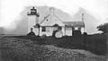
Nayatt Point Lighthouse, c. late 1800s
-
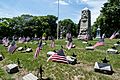
Prince's Hill Burial Ground


See also
 In Spanish: Barrington (Rhode Island) para niños
