
Bear River (Feather River tributary) facts for kids
Quick facts for kids Bear River |
|
|---|---|

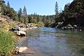
Bear River in the Sierra foothills
|
|

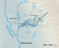
Map of the Bear River watershed
|
|
| Other name(s) | Arroyo de los Osos |
| Country | United States |
| State | California |
| Physical characteristics | |
| Main source | Sierra Nevada 4,800 ft (1,500 m) 39°18′29″N 120°39′23″W / 39.30806°N 120.65639°W |
| River mouth | Feather River Sacramento Valley, United States 23 ft (7.0 m) 38°56′23″N 121°34′51″W / 38.93972°N 121.58083°W |
| Length | 73 mi (117 km) |
| Basin features | |
| Basin size | 295 sq mi (760 km2) |
The Bear River is a river in California that flows into the Feather River. It starts high up in the Sierra Nevada mountains. The river winds through four counties: Yuba, Sutter, Placer, and Nevada. It is about 73 miles (117 km) long.
The Bear River generally flows southwest through the mountains. Then it turns west as it enters the Central Valley. The river drains a narrow area of land, about 295 square miles (760 km2). This area is called its watershed.
It's important to know that the California Office of Environmental Health Hazard Assessment has given advice about fish from the Bear River. They suggest being careful with fish caught there because of higher levels of mercury.
Contents
Where Does the Bear River Flow?

The Bear River begins as a tiny stream at Emigrant Gap. This spot is on the border of Nevada and Placer Counties. It's located within the Tahoe National Forest. The river's starting point is on a ridge. To its south is the North Fork American River, and to its north is the South Yuba River.
As the river flows west, it enters Bear Valley. Then it goes into a deep, narrow canyon. It passes by the town of Dutch Flat. The river continues along the Nevada–Placer County line. It is joined by Steephollow Creek from the north.
The river then widens into Rollins Reservoir. This reservoir is formed by the 242-foot (74 m) high Rollins Dam. While in the reservoir, Greenhorn Creek joins the river from the north.
Journey Through the Foothills and Valley
Below Rollins Dam, the river flows southwest. It goes through the Sierra foothills. It passes towns like Colfax and Meadow Vista. The river also flows through Lake Combie. After a short, rugged canyon, it widens into Camp Far West Reservoir. Here, it starts to form the border between Placer and Yuba Counties.
Further west, the Bear River enters the Sacramento Valley. It creates a large flat area of land called an alluvial floodplain. Starting at Wheatland, it forms the border of Yuba and Sutter Counties. A few miles downstream, Dry Creek joins it from the north.
Finally, the Bear River flows into the Feather River at Nicolaus. This is about 11 miles (18 km) upstream from where the Feather River meets the larger Sacramento River. It's also about 20 miles (32 km) south of Yuba City and Marysville.
How Much Water Does It Carry?
The Bear River is the smallest main river that flows into the Feather River. On average, it carries about 410 cubic feet per second (12 m3/s) of water near Wheatland each year. The amount of water changes throughout the year. In March, it can carry about 1,130 cubic feet per second (32 m3/s). In September, it might only carry 20 cubic feet per second (0.57 m3/s).
The Bear River's watershed is not as high up as other Sierra streams. This means that most of its water comes from rainfall, not melting snow. Also, many dams and diversions on the river greatly affect how much water flows.
How the Bear River Changed Over Time
Scientists believe the Bear River used to be much larger. Millions of years ago, a bigger, snow-fed river flowed through its channel. In ancient times, the upper part of the South Yuba River used to flow into the Bear River at Emigrant Gap.
However, a process called stream piracy happened. This means one river "captured" the water from another. This might have been helped by glaciers during the Ice Ages. As a result, the upper Bear River's water was taken by the Yuba River system to the north. This made the Bear River about 25 miles (40 km) shorter than it once was.
Bear River and the Gold Rush

The Bear River area is part of California's famous Gold Country. In the 1800s, during the California Gold Rush, this region was one of the richest places for gold. Many important mining towns were in the Bear River basin. These included You Bet, Red Dog, Dutch Flat, Gold Run, and others.
A mining method called hydraulic mining greatly changed the land around the Bear River. This method used powerful jets of water to wash away hillsides to find gold. For example, at You Bet and Red Dog, about 47,000,000 cubic yards (36,000,000 m3) of gravel with gold was washed away. At Dutch Flat, it was 105,000,000 cubic yards (80,000,000 m3), and at Gold Run, 128,000,000 cubic yards (98,000,000 m3).
How People Have Changed the Bear River
The Bear River has been significantly changed by people. Many dams and diversions have been built. These structures help with irrigation (watering crops), providing drinking water, and generating electricity. Water from the larger Yuba River basin to the north is also brought into the Bear River. This happens through big projects like the Drum-Spaulding and Yuba-Bear Hydroelectric Projects.
These projects involve a complex system of about 40 reservoirs. They are on the Middle and South Forks of the Yuba River and the upper Bear River. Even though they are technically separate, they work together as one big system.
Dams and Diversions on the Bear River
About 200,000 acre-feet (0.25 km3) of water from the Yuba River Basin flows into the Bear River Basin. This happens through the Drum Canal. The highest dams on the Bear River itself are at Dutch Flat Forebay and Dutch Flat Afterbay. These are small dams used to divert water for electricity. Water from the upper Bear River and the Drum Canal flows through these dams. It then powers electricity plants at Drum, Dutch Flat, and Chicago Park.
Below the Chicago Park Powerhouse, the Bear River is held back by Rollins Dam. This dam creates a 66,000-acre-foot (0.081 km3) reservoir. Rollins Reservoir stores water for farming and electricity. It also helps trap sediment (like dirt and rocks) left over from the old hydraulic mining activities.
Right below Rollins Dam is the Bear River Diversion Dam. This dam diverts about 290,000 acre-feet (0.36 km3) of water each year. This water goes into the Bear River Canal. The canal provides water for several rural communities in Placer County. Any extra water from this canal flows into the American River basin.
The rest of the water in the Bear River flows downstream to Lake Combie. This lake holds about 3,500 acre-feet (4,300,000 m3) of water. The Van Giesen Dam, which forms Lake Combie, is the oldest dam on the main Bear River. It was finished in 1928. This dam sends water into the Combie Aqueduct. This aqueduct supplies about 40 percent of the water for a local water district.
Further downstream is Camp Far West Dam. This dam creates the largest reservoir on the river, holding 104,500 acre-feet (0.1289 km3). This reservoir helps control floods and provides water for farming in the lower Bear River valley. Another mile downstream is Camp Far West Diversion Dam. This is the last dam on the river. It diverts 124,500 acre-feet (0.1536 km3) of water each year. This water goes into canals to irrigate about 64,000 acres (26,000 ha) of farmland in the Sacramento Valley. About 80 percent of this farmland is used to grow rice.
New Dam Ideas for the Bear River
Sometimes, there are ideas for building new dams on the Bear River. In 2011, some water districts looked into building a new dam. This proposed dam, called Garden Bar Dam, would have been north of Camp Far West Reservoir. It would have flooded parts of Nevada and Placer Counties. This area is already set aside for conservation and wildlife. The new lake would have covered important wildlife homes and grasslands.
There were concerns that there might not be enough water to fill such a large new reservoir. The water is already used by existing lakes like Camp Far West, Combie, and Rollins. Because of these concerns, and strong opposition from environmental groups, local land trusts, and ranchers, the idea for Garden Bar Dam was dropped in 2012.
In 2014, another plan for a new dam came up. This proposed dam, called Centennial Dam, would be just above Lake Combie. It would store about 112,000 acre-feet (0.138 km3) of water. Groups like the Foothills Water Network and South Yuba River Citizens League (SYRCL) created a campaign called "Save the Bear, Stop Centennial" to oppose this plan.
Images for kids
-
Bear River in the Sierra foothills
-
Map of the Bear River watershed
