Boreas Pass facts for kids
Quick facts for kids Boreas Pass |
|
|---|---|

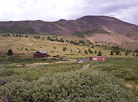
Boreas Pass in summer
|
|
| Elevation | 11,481 ft (3,499 m)NAVD 88 |
| Traversed by | Boreas Pass Road (unpaved) |
| Location | Park / Summit counties, Colorado, U.S. |
| Range | Front Range |
| Coordinates | 39°24′37″N 105°58′05″W / 39.41028°N 105.96806°W |
| Topo map | USGS Boreas Pass |
Boreas Pass is a high mountain pass in the middle of Colorado. It's located in the Rocky Mountains of the western United States. This pass is very high up, at 11,481 feet (3,499 meters) above sea level!
Boreas Pass sits right on the continental divide. This is like a giant line across North America. Water on one side flows to the Pacific Ocean. Water on the other side flows to the Atlantic. The pass is found where Park and Summit counties meet.
Contents
Exploring Boreas Pass
Boreas Pass crosses a mountain range. It separates the start of the Blue River to the north. This river flows into the Colorado River. To the south, it separates the start of the South Platte River in South Park.
The Road Over the Pass
Today, Forest Service Road 33 goes over the pass. It's a gravel road. The road is closed in winter because of heavy snow. But in good weather, regular cars can drive on it. When it's snowy, people use the road for cross-country skiing.
The road starts north of Como. This town is in northern South Park. It then goes north towards Breckenridge. The road offers amazing views of aspen trees. You can also see nearby Mount Silverheels and the Tenmile Range. Many bicyclists love to ride up to the top from Breckenridge. It's a popular round trip!
A Look Back in Time
Boreas Pass has a rich history. It was once called Breckenridge Pass in the 1860s.
Gold Rush Days
Thousands of prospectors used this pass. They were looking for gold during the Colorado Gold Rush. They crossed from South Park to the Blue River valley. In 1866, the path was made wider. It became a wagon road for stagecoaches.
The Railroad Arrives
In 1882, a railroad started building tracks here. It was the Denver, South Park and Pacific Railroad. Sidney Dillon of the Union Pacific Railroad led the project. He renamed the pass "Boreas Pass." This was in honor of Boreas, the Ancient Greek god of the North Wind.
The railroad line was a branch to Breckenridge. It eventually went all the way to Leadville. A roundhouse was built in Como. This building is still there today.
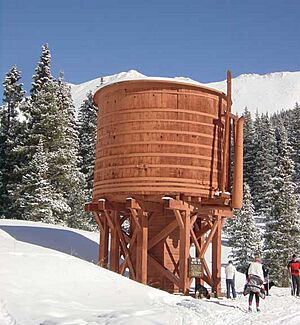
Building the railroad over the pass was a huge challenge. There was a lot of snow at such a high altitude. The tracks had a steep slope in many places. Many snow sheds were built along the route. These sheds protected the tracks from snow.
A town called Boreas was built at the top. It's now a ghost town. It was mainly built to house workers. Their job was to clear the tracks in winter. The railroad line was closed in 1937.
After World War II, the Army Corps of Engineers rebuilt the route. They made it suitable for cars. On the north side of the pass, Forest Service Road 593 leads to Dyersville. This is another 1880s ghost town. You can also find many old mining sites there.
Water Diversion
The Boreas Pass Ditch was finished in 1910. It was built to move water over the pass. Water from Indiana Creek, a branch of the Blue River, was sent into North Tarryall Creek. This creek flows into the South Platte River.
The ditch is 0.8 miles (1.3 km) long. It can carry 16 cubic feet of water per second. On average, it moves about 140 acre-feet (170,000 cubic meters) of water each year. The ditch was first built to water farms in South Park. Today, it helps supply water to the city of Englewood. The city fixed up the ditch in 1990.
Historic Site
The Boreas Railroad Station Site is a special place. It is listed on the National Register of Historic Places. This means it's an important historical landmark.
 | Dorothy Vaughan |
 | Charles Henry Turner |
 | Hildrus Poindexter |
 | Henry Cecil McBay |


