Brentwood, New Hampshire facts for kids
Quick facts for kids
Brentwood, New Hampshire
|
||
|---|---|---|

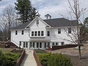
Mary E. Bartlett Library
|
||
|
||

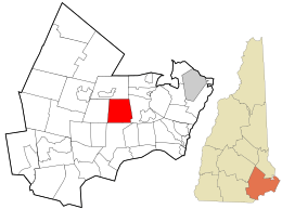
Location in Rockingham County and the state of New Hampshire.
|
||
| Country | United States | |
| State | New Hampshire | |
| County | Rockingham | |
| Incorporated | 1742 | |
| Named for | Brentwood, Essex | |
| Villages |
|
|
| Area | ||
| • Total | 17.0 sq mi (44.0 km2) | |
| • Land | 16.8 sq mi (43.6 km2) | |
| • Water | 0.2 sq mi (0.4 km2) 0.93% | |
| Elevation | 115 ft (35 m) | |
| Population
(2020)
|
||
| • Total | 4,490 | |
| • Density | 267/sq mi (103.1/km2) | |
| Time zone | UTC-5 (Eastern) | |
| • Summer (DST) | UTC-4 (Eastern) | |
| ZIP code |
03833
|
|
| Area code(s) | 603 | |
| FIPS code | 33-07220 | |
| GNIS feature ID | 0873550 | |
Brentwood is a town in New Hampshire, USA. It's located in Rockingham County. In 2020, about 4,490 people lived there. Since 1997, Brentwood has been the main town, or 'county seat', for Rockingham County. This means it's where the county's government offices are located.
Contents
History of Brentwood
Early Days and Native Americans
Long ago, the Pennacook tribe, part of the Abenaki people, lived in the area now known as Brentwood. They farmed, fished, and hunted here. Old trails, like one along the Exeter River, show where they traveled. People have found arrowheads and other tools from their time.
The first European settlers arrived in 1652. They built a sawmill by the Exeter River, using the river's power to cut wood.
How Brentwood Became a Town
Brentwood was once part of a bigger town called Exeter. It got its name from a town in England, also called Brentwood. That English town was once known as 'Burnt Wood' because a king allowed a forest to be cut and burned there long ago.
Starting in 1738, people living in this part of Exeter wanted to become their own town. It was hard for them to travel to the church in Exeter, and they still had to pay taxes there. After many requests, colonial governor Benning Wentworth officially made Brentwood its own town on June 26, 1742.
For a while, the town had some disagreements about where to build their church. Eventually, in 1764, Brentwood divided into two parts. The western half became a new town called "Poplin," which is now known as Fremont.
Growth and Changes
In its early years, Brentwood had many mills along its rivers. These mills helped produce lumber and other goods. Over time, the town's economy shifted more towards agriculture, meaning farming became very important. Today, Brentwood is mostly a residential town, where many people live.
The main county offices for Rockingham County are in Brentwood. This area, known as the Rockingham County Complex, used to be a "poor farm" or "county farm" where people could live and work. Now, it has administrative offices, a nursing home, and the county jail. In 1997, Brentwood officially became the county seat when these offices moved there.
Most of the shops and businesses are located along Calef Road. There's also an industrial area in the northeast part of town.
In 2014, a sad event happened when police officer Stephen Arkell was shot and killed while investigating a problem. Many memorials and events now honor him. In 2021, a section of Route 125 in Brentwood was named the Officer Stephen Arkell Memorial Highway.
Geography of Brentwood
Brentwood is shaped almost like a square. The town covers about 44 square kilometers (17 square miles). Most of this area is land, with a small amount of water. The highest point in Brentwood is Great Hill, which is about 84 meters (275 feet) above sea level.
The town has several rivers and streams. The Exeter River and Dudley Brook flow through Brentwood. The Piscassic River also crosses the northwestern part of town. All these waterways are part of the larger Piscataqua River watershed, which eventually flows into the ocean.
Neighboring Towns
Brentwood shares its borders with these towns:
Getting Around Brentwood
Middle Road (Route 111A) runs across the town from east to west. Other important roads include North Road and South Road. Calef Road (Route 125) is the main road that runs north and south.
The highway Route 101 runs near Brentwood's northern border. This highway helps people travel to cities like Manchester and to the coastal areas.
For public transportation, you can take a bus from a park and ride lot near Calef Road to Boston, Massachusetts and its Logan Airport. There's also shuttle bus service available to Manchester Boston Regional Airport.
Places of Worship
Brentwood has several places where people gather for religious services. The original church, located on Route 111A, is now called the Pilgrim United Church of Christ, Brentwood-Kingston. The Brentwood First Baptist Church has been in the same spot since 1771. Grace Ministries holds religious services and runs a Christian school. There is also a Kingdom Hall of Jehovah’s Witnesses, which has two congregations.
Population Information
| Historical population | |||
|---|---|---|---|
| Census | Pop. | %± | |
| 1790 | 976 | — | |
| 1800 | 899 | −7.9% | |
| 1810 | 905 | 0.7% | |
| 1820 | 892 | −1.4% | |
| 1830 | 891 | −0.1% | |
| 1840 | 888 | −0.3% | |
| 1850 | 923 | 3.9% | |
| 1860 | 887 | −3.9% | |
| 1870 | 895 | 0.9% | |
| 1880 | 999 | 11.6% | |
| 1890 | 967 | −3.2% | |
| 1900 | 957 | −1.0% | |
| 1910 | 759 | −20.7% | |
| 1920 | 685 | −9.7% | |
| 1930 | 725 | 5.8% | |
| 1940 | 720 | −0.7% | |
| 1950 | 819 | 13.8% | |
| 1960 | 1,072 | 30.9% | |
| 1970 | 1,468 | 36.9% | |
| 1980 | 2,004 | 36.5% | |
| 1990 | 2,590 | 29.2% | |
| 2000 | 3,197 | 23.4% | |
| 2010 | 4,486 | 40.3% | |
| 2020 | 4,490 | 0.1% | |
| U.S. Decennial Census | |||
According to the census from 2010, there were 4,486 people living in Brentwood. Most of the people were White (96.3%). A small percentage were African American, Native American, or Asian. About 1.5% of the population was Hispanic or Latino.
In 2010, about 46.2% of homes had children under 18 living there. Most households (71.6%) were married couples. The average age of people in Brentwood was about 41 years old.
The estimated average yearly income for a family in Brentwood was around $111,650 between 2007 and 2011. This shows that Brentwood is a community with a good income level.
Notable People from Brentwood
- Ted King (born 1983), a professional cyclist.
- Joshua Smith (1760–1795), an author and minister.
- William Morrill Wadley (1813–1882), a railroad superintendent.
Images for kids
See also
 In Spanish: Brentwood (Nuevo Hampshire) para niños
 | May Edward Chinn |
 | Rebecca Cole |
 | Alexa Canady |
 | Dorothy Lavinia Brown |


