Interstate 238 and State Route 238 (California) facts for kids
Quick facts for kids
[[File:|x70px|alt= marker]] |
||||
|---|---|---|---|---|
|
I-238 highlighted in red; SR 238 in purple
|
||||
| Route information | ||||
| Defined by S&HC § 538 | ||||
| Maintained by Caltrans | ||||
| Length | 16.519 mi (26.585 km) | |||
| History | Designated 1934 (as SR 9) July 1, 1964 renumbered SR 238 Northernmost portion designated I-238 in May 1983 by FHWA |
|||
| Component highways |
|
|||
| Major junctions | ||||
| South end | ||||
|
||||
| North end | ||||
| Location | ||||
| Counties: | Alameda | |||
| Highway system | ||||
| State highways in California(list • pre-1964) History • Unconstructed • Deleted • Freeway • Scenic
|
||||
Route 238 is a road in the San Francisco Bay Area of California. It's made up of two main parts: State Route 238 (SR 238) and Interstate 238 (I-238). Even though it's called "Route 238," it's not a single, continuous road.
SR 238 is a multi-lane highway that runs mostly north and south. It goes along the Hayward hills, connecting Fremont and Castro Valley. I-238 is a six-lane freeway that runs more east and west. It connects Castro Valley to San Leandro.
The number "I-238" is a bit unusual for an Interstate highway. Usually, three-digit Interstate numbers start with a number that connects to a main two-digit Interstate. For example, I-405 connects to I-5. But there is no "I-38" in the United States. California asked for this special number because all the other common three-digit numbers related to I-80 (a major Interstate in the Bay Area) were already taken.
| Top - 0-9 A B C D E F G H I J K L M N O P Q R S T U V W X Y Z |
What is Route 238?
Route 238 is an important road in California. It's part of the California Freeway and Expressway System. This system includes major roads that help people and goods move around the state. It's also part of the National Highway System. This is a group of highways that are very important for the country's economy, defense, and travel. The Federal Highway Administration (FHWA) decides which roads are part of this system.
State Route 238 (SR 238)
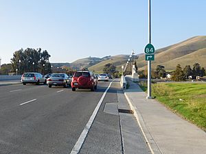
SR 238 starts in Fremont at I-680. It then goes through Union City and Hayward. It ends at I-580 in Castro Valley. This part of the road runs next to the Hayward hills.
In some areas, SR 238 has different names. From I-680 to SR 92 and SR 185 in Hayward, it's called Mission Boulevard. In northern Hayward, from A Street to I-580, it's called Foothill Boulevard.
In Downtown Hayward, there's a special traffic setup called the "Hayward Loop." If you're going north on SR 238, you stay on Foothill Boulevard. But if you're going south, you turn onto A Street and then Mission Boulevard. This loop helps traffic flow better through the busy downtown area.
Mission Boulevard's History
Mission Boulevard has a long history. It used to be part of the El Camino Real. This was a historic road that connected the old Spanish missions in California. Mission Boulevard gets its name because it passes by Mission San José. This mission was founded way back in 1797.
Mission Boulevard goes through several historic towns. These include the Mission San Jose and Niles areas of Fremont. It also goes through the Decoto area of Union City and the city of Hayward. This road is also very close to the Hayward Fault. This is a major earthquake fault line that runs along the base of the hills.
Interstate 238 (I-238)
I-238 is a short freeway, about 2.23 miles (3.59 km) long. Even though it mostly runs east and west, the California Department of Transportation (Caltrans) officially calls it a north-south freeway. This is because the rest of Route 238 is mostly north-south.
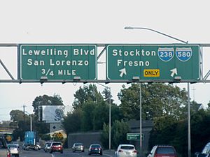
I-238 starts at I-580 and SR 238 in Castro Valley. From there, it goes through parts of Ashland and Cherryland. It ends in San Leandro at I-880.
This freeway is very important for trucks. Trucks that are heavier than 4.5 short tons (4.1 metric tons) are not allowed on I-580 through Oakland. So, I-238 and I-880 offer an alternate route for these large trucks.
Why I-238 has a unique number
As mentioned, I-238 doesn't follow the usual rules for naming Interstate highways. Normally, a three-digit Interstate number starts with a number that links to a main two-digit Interstate. For example, I-105 connects to I-5. But there is no "I-38" in the U.S. Interstate system.
I-238 connects two other Interstate routes that are related to I-80. These are I-580 and I-880. Usually, a connecting road would use a number like I-180, I-280, I-380, and so on. However, when I-238 was named, many of these numbers were already in use in California. For example, I-880 was named at the same time. Because all the usual number combinations were taken, California asked for the I-238 number. The federal government agreed, even though it was unusual.
History of Route 238
Early Days as State Route 9
Before 1964, California changed many of its state highway numbers. Before that, SR 238 was part of a different road called SR 9. SR 9 used to go much further south, all the way to San Jose and Santa Cruz.
Canceled Freeway Plans
For many years, there were plans to turn SR 238 into a full freeway. This project was called the "Mission" or "Foothill" freeway. It would have stretched from I-680 in Fremont to Hayward. In 1968, California even tried to get it added to the Interstate Highway System, but it was rejected.
After many years of lawsuits and disagreements, Caltrans decided to cancel the freeway project in 2003. They then sold off the land they had bought for the freeway. Instead of a new freeway, they decided to improve the existing SR 238. This included adding more lanes and making other changes. In 2012, the California State Legislature gave control of SR 238 within Hayward to local authorities. In 2013, the "Hayward Loop" of one-way streets was created to help traffic flow better in downtown Hayward.
The I-238 Freeway Segment
The part of the road that is now I-238 was built as a freeway in 1956. Before 1964, it didn't have a specific number.
When I-880 was added to the Interstate system, this short piece of SR 238 was also added. It connected I-880 to I-580. Both I-238 and I-880 were officially approved on July 7, 1983. The interchanges, which are the places where roads connect, were rebuilt between 1988 and 1994. This helped add missing ramps between I-238 and I-880.
In 2006, a big project started to rebuild the entire length of I-238. This included making the interchange with I-880 better and adding an extra lane in each direction. Most of the bridges and overpasses were also replaced. This was done to make sure they met modern earthquake safety standards. The project finished in October 2009, ahead of schedule.
Major Intersections
The entire route is in Alameda County.
| Location | mi |
km | Exit | Destinations | Notes |
|---|---|---|---|---|---|
| Fremont | 0.00 | 0.00 | Mission Boulevard | This road continues beyond I-680 | |
| This is where SR 238 begins; I-680 Exit 16 | |||||
| 3.31 | 5.33 | Southern end where SR 84 joins SR 238 | |||
| 3.64 | 5.86 | Northern end where SR 84 leaves SR 238 | |||
| Union City | 6.78 | 10.91 | Decoto Road – Decoto District, Dumbarton Bridge | ||
| Hayward | 9.32 | 15.00 | This is the northern end of state maintenance | ||
| 9.94 | 16.00 | Tennyson Road | |||
| 11.20 | 18.02 | ||||
| 12.61 | 20.29 | No access for northbound traffic; this is the south end of the "Hayward Loop" one-way streets | |||
| Northbound traffic turns left on A Street; southbound traffic turns left from A Street onto Mission Boulevard | |||||
| 13.12 | 21.11 | A Street | North end of the "Hayward Loop" where southbound traffic turns onto A Street | ||
| Hayward–Castro Valley line | Southern end of state maintenance | ||||
| Castro Valley | 13.98 | 22.50 | Interchange; only for northbound exits and southbound entrances; I-580 Exit 34 | ||
| Interchange; only for northbound exits | |||||
| 14.29 | 23.00 | Castro Valley Boulevard, Mattox Road | Interchange for northbound traffic and a regular intersection for southbound traffic | ||
| This is where SR 238 ends and the I-238 Freeway begins | |||||
| 14.47 | 23.29 | 14 | Southbound left exit and northbound left entrance; I-580 Exit 34 | ||
| Ashland | 14.93 | 24.03 | 15 | Mission Boulevard is not signed northbound even though SR 185 crosses I-238 here | |
| San Leandro | 16.03 | 25.80 | 16A | Northbound exit and southbound entrance; I-880 North Exit 31A | |
| 16.28 | 26.20 | 16B | Hesperian Boulevard – San Lorenzo | Northbound exit and southbound entrance | |
| 16.68 | 26.84 | 17A | Washington Avenue | Northbound exit and southbound entrance | |
| 16.70 | 26.88 | 17B | Northbound exit and southbound entrance; this is where I-238 ends; I-880 South Exit 31 | ||
| 1.000 mi = 1.609 km; 1.000 km = 0.621 mi | |||||
See also
 In Spanish: Ruta Estatal de California 238 para niños
 | William Lucy |
 | Charles Hayes |
 | Cleveland Robinson |


