
Fremont, California facts for kids
Quick facts for kids
Fremont, California
|
||
|---|---|---|
|
|
||
|
||
| Country | ||
| State | ||
| County | Alameda | |
| Incorporated | January 23, 1956 | |
| Named for | John C. Frémont | |
| Government | ||
| • Type | Council–manager | |
| Area | ||
| • Total | 88.46 sq mi (229.10 km2) | |
| • Land | 78.31 sq mi (202.83 km2) | |
| • Water | 10.14 sq mi (26.27 km2) 11.6% | |
| Elevation | 56 ft (17 m) | |
| Population
(2020)
|
||
| • Total | 230,504 | |
| • Rank | 2nd in Alameda County 16th in California 99th in the United States |
|
| • Density | 2,605.74/sq mi (1,006.128/km2) | |
| Time zone | UTC−8 (Pacific) | |
| • Summer (DST) | UTC−7 (PDT) | |
| ZIP codes |
94536–94539, 94555
|
|
| Area code | 510, 341 | |
| FIPS code | 06-26000 | |
| GNIS feature IDs | 277521, 2410545 | |
_(cropped).JPG)
.JPG)
.jpg)

_(cropped).JPG)

Fremont is a city in Alameda County, California, in the United States. It is located in the East Bay area of the Bay Area. Fremont has a population of over 230,000 people as of 2020. This makes it the fourth largest city in the Bay Area. Only San Jose, San Francisco, and Oakland are larger.
Fremont is very close to Silicon Valley, a famous area for high-tech companies. Because of this, Fremont has many tech businesses. The city started around Mission San José. Spanish missionaries founded this mission in 1797. Fremont became an official city on January 23, 1956. This happened when five smaller towns joined together. The city is named after John C. Frémont. He was a general who helped the U.S. take California from Mexico.
Contents
- Discovering Fremont's History
- Exploring Fremont's Geography
- Centerville District: A Historic Hub
- Niles District: Silent Movie History
- Irvington District: A Changing Name
- Mission San Jose District: High Peaks and High Schools
- Warm Springs District: Tech and Growth
- Central District: Fremont's Heart
- North Fremont District: Residential and Parks
- South Fremont District: Industry and Innovation
- Bayside Industrial District: Business Hub
- Hill Area District: Open Spaces
- Fremont's Climate: Warm Summers, Mild Winters
- Fremont's Population and People
- Fremont's Economy and Top Employers
- Culture, Recreation, and Media in Fremont
- Education in Fremont
- Transportation in Fremont
- Famous People from Fremont
- Fremont's Sister Cities
- Images for kids
- See also
Discovering Fremont's History

Fremont's Early Beginnings
The recorded history of the Fremont area started on June 6, 1797. This is when the Spanish Father Fermín de Lasuén founded Mission San José. The mission was built where the Ohlone village of Oroysom once stood. The Ohlone people lived in dome-shaped homes. These were made from redwood bark or woven plants. They mostly hunted and gathered food. Men hunted animals like deer and bears. Women collected nuts, berries, and root vegetables. The Ohlone lived near rivers for resources like fish.
Spanish soldiers and missionaries arrived in California in 1769. They wanted to expand Spanish rule and convert Native Americans. The Ohlone people were invited to live and work at the missions. Before the missions, Natives used tools made of stone and bone. Missionaries taught them to make metal tools and adobe bricks. These bricks were used to build missions. The Spanish also brought cattle, pigs, and sheep. They encouraged the Ohlone to farm instead of hunting. Living in the missions meant the Ohlone were forced to become Christians. They were told to forget their traditional beliefs. Also, diseases brought by the Spanish caused many deaths.
In 1827, Jedediah Smith, a famous trapper, was the first English-speaking visitor. The Mission grew, reaching 1,887 people by 1831. The missionaries' influence decreased after 1834. This was when the Mexican government took control of the missions.
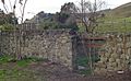
José de Jesus Vallejo was a key figure in the Fremont area. His family owned a flour mill near Niles Canyon. In 1846, John C. Frémont led a military trip. He mapped a trail through Mission Pass. He also helped the U.S. take California from Mexico.

The Fremont area grew quickly during the California Gold Rush. A town called Mission San José formed around the old mission. It had its own post office by 1850. Farming was the main business. Grapes, plants, and olives were important crops. In 1868, a strong earthquake damaged buildings in the Fremont area. It ruined Mission San José. The Palmdale Winery was the largest in California until 1906. Its ruins are still visible in Irvington.
From 1912 to 1915, the Niles area was a center for early movies. Charlie Chaplin filmed several movies here. His famous film The Tramp was made in Fremont.
How Fremont Became a City
Fremont became an official city in 1956. This happened when five towns joined together. These towns were Irvington, Centerville, Mission San José, Niles, and Warm Springs. Wally Pond led the committee that helped create the city. Glenmoor Gardens, a large housing area, was being built then. Its homeowners' association helped provide services. These services included police and fire protection.
Fremont became more industrial between 1953 and 1962. The first Fremont post office opened in 1956. In the 1980s and 1990s, many high-tech jobs came to Fremont. This led to fast growth, especially in the Warm Springs District. Fremont became connected to Silicon Valley. The Apple factory that made the first Mac computer was in Fremont. Production stopped there in 1993. Other tech companies also opened offices in the city. By 1999, about 750 high-tech firms were in Fremont. This tech growth continues today and is a major industry.

The General Motors car factory in South Fremont was the city's biggest employer. In the 1980s, it became a joint project with Toyota. It was renamed NUMMI. Toyota and NUMMI closed their operations in 2010. Tesla Motors bought part of the plant in June 2010. It is now their main production plant, called the Tesla Factory.
Exploring Fremont's Geography
In 1956, five small towns joined to form Fremont. These were Centerville, Niles, Irvington, Mission San José, and Warm Springs. They were located between the East Bay hills and the San Francisco Bay. Today, these areas have grown a lot. They are now considered districts of Fremont. The town of Newark was supposed to join too. But its voters decided not to. Newark became its own city in 1955.
Fremont, along with Newark and Union City, is known as the Tri-City Area.
Centerville District: A Historic Hub
Centerville was once the main town in Washington Township. It is located at 37°33′15″N 121°59′57″W / 37.55417°N 121.99917°W. The area is about 52 feet (16 meters) above sea level. George Lloyd started Centerville in 1850 by selling cold beer. Captain George Bond opened a general store. The post office opened in 1855. The Centerville Pioneer Cemetery holds the graves of many early settlers.
Centerville has roots with Native Americans. Spanish, Mexican, Italian, Portuguese, and Swiss people settled here. They helped Centerville grow. Early Centerville was a quiet farming area. It had large Spanish land grants that were divided into smaller farms. The Freitas Ranch was one of the largest farms. There were many fruit orchards and fields of fresh produce.

During World War II, many Japanese American families living in Centerville were forced to leave their homes. This was due to a government order.
Centerville was also a major stop for early railways. This helped local farmers get their produce to market quickly. There was a large cannery near the tracks. In 1959, a big fire destroyed the cannery. It was the largest fire in Fremont's history. The cannery was never rebuilt.
New homes started to appear after World War II. Most of these homes were along Fremont Boulevard and Thornton Avenue. For city planning, Centerville was expanded. It now includes areas like Glenmoor Gardens and Cabrillo Park. Two high schools serve the area: Washington High School (established 1892) and American High School (established 1972). There are also two middle schools.
Niles District: Silent Movie History

The former town of Niles is separated from other parts of Fremont. It is located at 37°34′44″N 121°58′40″W / 37.57889°N 121.97778°W. It is about 112 feet (34 meters) above sea level. Old Town Niles has its own library, post office, and a silent movie theater. It also has many antique and craft stores.
The community was once called Vallejo Mills. It got its name from the Central Pacific Railroad's Niles station. This station opened in 1870. A post office opened in Niles in 1873.
Niles was home to Essanay Studios from 1912 to 1916. This was one of the first movie companies on the West Coast. Charlie Chaplin filmed some of his famous silent movies in Niles. The Niles Essanay Silent Film Museum shows artifacts from Niles' early years. Every Saturday, they screen silent films. Many of these films were made locally.
The Niles Canyon Railway runs along Alameda Creek. It offers train rides on weekends. A popular "train of lights" runs during the holidays. The Niles Canyon Railroad has a collection of historic trains.
Irvington District: A Changing Name
The Irvington District area was once called Irving. Its name changed many times. In the early 1850s, two freed Black men built the first building here. It was a tavern with an inn. This spot is now known as "Five Corners" or Irvington Square. The inn and other old buildings were torn down in the 1980s.
In 1871, Washington College was founded nearby. It was the first industrial school in California. The U.S. Postal Service opened a post office called Washington Corners in 1870. This became the name of the settlement.
In 1884, locals chose the name Irving for their town. It honored Judge Irving, a traveling judge. Later, the railroad mistakenly listed the train depot as "Irvington." The town asked them to fix it. But the railroad said it was too expensive to change the pamphlets. So, in 1887, the town changed its name to Irvington.
The Irvington district has two main areas: Irvington Woods and Irvington Square. It is a diverse neighborhood. For city planning, Irvington was expanded. It now includes areas like Sundale and Blacow. Three high schools serve the area: Irvington High School, Robertson High School, and John F. Kennedy High School.
Mission San Jose District: High Peaks and High Schools

During the California Gold Rush, a busy town grew around the old Mission. It helped equip people traveling to the gold fields. A post office opened in Mission San Jose in 1850.
This district, like Niles, is surrounded by hills. The hills here are taller and steeper. The highest points are on the Mission Ridge. Mission San Jose district is near Mission Peak and Mount Allison. These peaks are over 2,500 feet (762 meters) high. They sometimes get snow. Mission Peak is a popular place for hiking.
Fremont's community college, Ohlone College, is near the mission. It serves over 12,000 students.
Mission San Jose has the largest group of Asian Americans in Fremont. Over 50% of the population was Asian in 2000. The local high school is Mission San Jose High School. It is ranked as one of the best high schools in the nation. The average family income in Mission San Jose was high in 2005. Many professionals move here for the top-performing public schools.
Mission San Jose: A Rebuilt Landmark

At the base of Fremont's hills is Mission San José. It is one of the oldest Spanish missions in California. The church building you see today is a reconstruction. The original 1809 adobe church was destroyed by an earthquake in 1868. Part of the original mission building remains. It now houses a museum. Mission San Jose is located at 37°31′59″N 121°55′13″W / 37.53306°N 121.92028°W. It is about 305 feet (93 meters) above sea level.
Warm Springs District: Tech and Growth

The former town of Warm Springs is named for the natural springs there. A post office opened in Harrisburgh in 1865. Its name changed to Warm Springs in 1885.
The Warm Springs district is the southernmost part of Fremont. It is a hub for many high-tech companies. These include Nielsen Norman Group, Lam Research, and Corsair. The district also has industrial businesses. The San Jose mission is also nearby.
Warm Springs is a shopping center for the Mission San Jose district. This is especially true since Pacific Commons, a large shopping center, was built. The BART extension to Warm Springs opened on March 25, 2017.
Central District: Fremont's Heart

The Central district is surrounded by Centerville, Niles, Mission San Jose, and Irvington. It has many shopping centers, like the Fremont Hub. The Fremont BART station is also here. It has health care centers and Central Park (Lake Elizabeth).
City planners want to create a walkable downtown area. It will have medium-sized buildings and be near public transport. This area is called Downtown Fremont. A new road, Capital Avenue extension, was finished in 2016. This helps support the downtown plans.
Most of Fremont is part of the Laguna Creek Watershed.
North Fremont District: Residential and Parks

North Fremont is mostly a residential area. It is near Union City, Newark, and Coyote Hills Regional Park. It is a growing community. It includes the Ardenwood, Lakes and Birds, and Northgate neighborhoods. It is home to the Ardenwood Historic Farm. This farm features the George Washington Patterson House. The Ardenwood Technology Park is also in this district. A 99 Ranch Market is one of many Asian businesses here. Thornton Middle School and American High School serve this community.
South Fremont District: Industry and Innovation
South Fremont is mainly an industrial district. It is home to the Tesla Factory. It also has the Warm Springs / South Fremont BART station. Thousands of new homes were being built here in 2016. In 2022, a pedestrian bridge was built from the BART station to Lopes Court. It cost $41 million.
Bayside Industrial District: Business Hub
Bayside Industrial is a district mainly for industry and businesses. It is located west of Interstate 880. It is between Newark and Milpitas.
Hill Area District: Open Spaces
The Hill Area is an open land district. It forms the eastern edge of Fremont. It is the site of Mission Peak.
Fremont's Climate: Warm Summers, Mild Winters
Fremont has a warm-summer Mediterranean climate. This is common in the San Francisco Bay Area. It means summers are warm and dry. Winters are cool and wet. Fremont gets about 17 inches (43 cm) of rain each year. This is because the city is in the rain shadow of the Santa Cruz Mountains. The highest temperature ever recorded was 110°F (43°C) on September 6, 2022. The lowest was 21°F (-6°C) on December 23, 1990.
| Climate data for Fremont, California, 1991–2020 normals, extremes 1996–present | |||||||||||||
|---|---|---|---|---|---|---|---|---|---|---|---|---|---|
| Month | Jan | Feb | Mar | Apr | May | Jun | Jul | Aug | Sep | Oct | Nov | Dec | Year |
| Record high °F (°C) | 74 (23) |
79 (26) |
87 (31) |
91 (33) |
98 (37) |
108 (42) |
103 (39) |
102 (39) |
110 (43) |
102 (39) |
84 (29) |
73 (23) |
110 (43) |
| Mean maximum °F (°C) | 67.5 (19.7) |
72.3 (22.4) |
77.2 (25.1) |
83.6 (28.7) |
87.9 (31.1) |
94.1 (34.5) |
91.1 (32.8) |
92.0 (33.3) |
93.1 (33.9) |
86.1 (30.1) |
77.1 (25.1) |
67.5 (19.7) |
96.6 (35.9) |
| Mean daily maximum °F (°C) | 58.6 (14.8) |
61.4 (16.3) |
65.1 (18.4) |
67.7 (19.8) |
71.1 (21.7) |
75.3 (24.1) |
77.9 (25.5) |
78.2 (25.7) |
78.3 (25.7) |
73.3 (22.9) |
64.6 (18.1) |
58.4 (14.7) |
69.2 (20.7) |
| Daily mean °F (°C) | 50.6 (10.3) |
52.9 (11.6) |
55.8 (13.2) |
58.0 (14.4) |
61.5 (16.4) |
65.0 (18.3) |
67.3 (19.6) |
67.7 (19.8) |
67.2 (19.6) |
62.6 (17.0) |
55.4 (13.0) |
50.5 (10.3) |
59.5 (15.3) |
| Mean daily minimum °F (°C) | 42.6 (5.9) |
44.4 (6.9) |
46.4 (8.0) |
48.3 (9.1) |
51.9 (11.1) |
54.7 (12.6) |
56.8 (13.8) |
57.1 (13.9) |
56.0 (13.3) |
52.0 (11.1) |
46.2 (7.9) |
42.5 (5.8) |
49.9 (9.9) |
| Mean minimum °F (°C) | 32.9 (0.5) |
34.9 (1.6) |
37.9 (3.3) |
40.5 (4.7) |
45.8 (7.7) |
49.1 (9.5) |
52.5 (11.4) |
53.5 (11.9) |
49.3 (9.6) |
44.1 (6.7) |
37.0 (2.8) |
31.7 (−0.2) |
30.6 (−0.8) |
| Record low °F (°C) | 26 (−3) |
31 (−1) |
34 (1) |
34 (1) |
41 (5) |
46 (8) |
48 (9) |
46 (8) |
46 (8) |
40 (4) |
32 (0) |
27 (−3) |
26 (−3) |
| Average precipitation inches (mm) | 3.00 (76) |
3.17 (81) |
2.52 (64) |
1.22 (31) |
0.50 (13) |
0.16 (4.1) |
0.00 (0.00) |
0.02 (0.51) |
0.10 (2.5) |
0.69 (18) |
1.59 (40) |
2.97 (75) |
15.94 (405) |
| Average precipitation days | 9.9 | 9.5 | 9.6 | 5.9 | 3.1 | 0.9 | 0.0 | 0.3 | 0.7 | 2.9 | 7.0 | 10.3 | 60.1 |
| Source 1: NOAA | |||||||||||||
| Source 2: National Weather Service (mean maxima/minima 2006–2020) | |||||||||||||
Fremont's Population and People
| Historical population | |||
|---|---|---|---|
| Census | Pop. | %± | |
| 1960 | 43,790 | — | |
| 1970 | 100,869 | 130.3% | |
| 1980 | 131,945 | 30.8% | |
| 1990 | 173,339 | 31.4% | |
| 2000 | 203,413 | 17.3% | |
| 2010 | 214,089 | 5.2% | |
| 2020 | 230,504 | 7.7% | |
| 2024 (est.) | 229,250 | 7.1% | |
| U.S. Decennial Census | |||
Understanding Fremont's Population in 2020
| Race / Ethnicity (NH = Non-Hispanic) | Pop 2000 | Pop 2010 | Pop 2020 | % 2000 | % 2010 | % 2020 |
|---|---|---|---|---|---|---|
| White alone (NH) | 84,149 | 56,766 | 38,160 | 41.37% | 26.52% | 16.56% |
| Black or African American alone (NH) | 6,084 | 6,743 | 5,108 | 2.99% | 3.15% | 2.22% |
| Native American or Alaska Native alone (NH) | 656 | 458 | 470 | 0.32% | 0.21% | 0.20% |
| Asian alone (NH) | 74,773 | 107,679 | 146,875 | 36.76% | 50.30% | 63.72% |
| Pacific Islander alone (NH) | 736 | 1,064 | 967 | 0.36% | 0.50% | 0.42% |
| Other race alone (NH) | 553 | 388 | 1,315 | 0.27% | 0.18% | 0.57% |
| Mixed race or Multiracial (NH) | 9,053 | 9,293 | 8,593 | 4.45% | 4.34% | 3.73% |
| Hispanic or Latino (any race) | 27,409 | 31,698 | 29,016 | 13.47% | 14.81% | 12.59% |
| Total | 203,413 | 214,089 | 230,504 | 100.00% | 100.00% | 100.00% |
In 2020, the average household income in Fremont was $142,374. About 4.5% of the population lived below the poverty line. This included 5.9% of those under 18.
Fremont's Diverse Community in 2010
.png)
In 2010, Fremont had a population of 214,089 people. Most people lived in households. There were 71,004 households. About 43.8% of them had children under 18. The average household had almost 3 people.
Fremont has a large community of Deaf people. This is because it is home to the California School for the Deaf. The Fremont Unified School District serves Fremont and parts of Union City and Hayward.
More than half of Fremont's residents were of Asian background in 2010. There were many people of Chinese, Indian, and Filipino descent. Fremont also has the largest group of Afghan Americans in the U.S. Many Afghans came here after the 1979 war in Afghanistan.
Fremont's Economy and Top Employers
Many companies have their main offices in Fremont. These include Antec Inc, Corsair Gaming, Electronics for Imaging, Lam Research, Seagate Technology, and Tailored Brands.
Leading Companies in Fremont
Here are the top employers in Fremont as of June 2024:
| # | Employer | # of Employees |
|---|---|---|
| 1 | Tesla, Inc. | 25,000 |
| 2 | Lam Research | 4,000 |
| 3 | Washington Hospital | 2,400 |
| 4 | Kaiser Permanente | 1,600 |
| 5 | Synnex | 1,400 |
| 6 | Western Digital | 1,100 |
| 7 | City of Fremont | 1,000 |
| 8 | Fremont Unified School District | 800 |
| 9 | Boehringer Ingelheim | 800 |
| 10 | Sutter Health | 775 |
Culture, Recreation, and Media in Fremont
Fremont has been a Tree City USA since 1996. This means it cares about its trees. There are about 55,000 trees in city parks and streets. The city has the Olive Hyde Art Gallery. It shows art from artists in the Bay Area. The gallery is in the former home of Olive Hyde.
Other interesting places in Fremont include:
- Fremont Central Park and Lake Elizabeth
- Ardenwood Historic Farm
- California Nursery Historical Park
- Don Edwards National Wildlife Refuge
- Mission Peak Regional Preserve
- Niles Essanay Silent Film Museum
- Washington Township Museum of Local History
- Quarry Lakes Regional Recreation Area
- Shinn Park and Arboretum
- Coyote Hills Regional Park
Local News in Fremont
The Tri-City Voice newspaper was started in 2002. It serves Fremont and nearby Union City and Newark. This weekly newspaper is based in Fremont.
Education in Fremont
Schools for All Ages
.JPG)
The Fremont Unified School District has five high schools. These are for grades 9–12. They are American, Irvington, Kennedy, Mission San Jose, and Washington. The Tak Fudenna Stadium is a large venue. It is used by all five high schools for sports and graduations. These schools are part of the Mission Valley Athletic League.
The district also has a continuation high school (Robertson). There are two independent study programs. It has an adult school. There are five middle schools for grades 6–8. And there are 29 elementary schools.
In 2019, several Fremont schools won awards. William Hopkins JHS, Mission San Jose HS, John F. Kennedy HS, and American HS received the California Distinguished Schools Award.
Fremont Christian School and Averroes High School are private schools. The California School for the Deaf, Fremont serves Northern California. It shares a campus with the California School for the Blind.
Colleges and Universities in Fremont
The Ohlone Community College District runs Ohlone College in Fremont. It also has a smaller campus in Newark. The University of Phoenix Bay Area Campus offers programs. San Francisco Bay University also has undergraduate and graduate programs.
Public Libraries in Fremont
The Alameda County Library has its main office in Fremont. The Fremont Main Library is the largest branch. It has the most books checked out. It also has a center for local history. The Alameda County Library has other branches in Centerville, Irvington, and Niles.
Transportation in Fremont


Fremont is served by major highways. These include Interstate 880 and Interstate 680. They are connected by Mission Boulevard. The city is also served by SR 84 and SR 238. The Dumbarton Bridge starts in Fremont.
There can be high noise levels along Interstate 880. The city and state have built noise barriers to help reduce this.
Trains provide regional transportation. These include BART and the Altamont Corridor Express (ACE). Fremont's BART station was once the last stop. A BART extension to the Warm Springs / South Fremont station opened in 2017. A further BART extension to San Jose opened in 2020. The Fremont-Centerville station is a stop for ACE and Amtrak's Capitol Corridor service. Local bus service is provided by AC Transit.
Future Rail Plans
Caltrain is planning a new rail line. It would connect the Peninsula and Alameda County. This would add Caltrain stations to Union City, Fremont-Centerville, Newark, and Menlo Park/East Palo Alto.
Famous People from Fremont
- John Buttencourt Avila, known for sweet potatoes
- Bud Harrelson, baseball player
- DeAnna Bennett, mixed martial artist
- Karen Chen, figure skater
- Rosalie Chiang, actress
- Emilio Castillo, from Tower of Power
- Vinod Dham, "father of the Intel Pentium"
- Shawon Dunston, baseball player
- Dina Eastwood, actress
- Dennis Eckersley, baseball Hall of Famer
- Harry Edwards, sociologist
- Yousef Erakat, YouTube star
- Qader Eshpari, Afghan musician
- Robb Flynn, musician
- Tony Gemignani, World Champion Pizza Maker
- Pragathi Guruprasad, Indian singer
- MC Hammer, musical artist
- Don Hertzfeldt, animator
- Ariel Hsing, Olympic table tennis player
- Khaled Hosseini, famous author
- Karin Ireland, author
- Dominic Kinnear, soccer player and coach
- Steven Kwan - MLB player
- Steve Lewis, Olympic sprinter
- Christine Liang, business leader
- Allan Haines Loughead, co-founder of Lockheed
- Mikh McKinney, basketball player
- Justin Medlock, NFL player
- Helen Wills Moody, tennis pro
- Lamond Murray, NBA basketball player
- Sammy Obeid, comedian
- Julie Pinson, actress
- Gary Plummer, NFL football player
- Rome Ramirez, from Sublime with Rome
- Randy Ready, baseball player
- Dick Ruthven, baseball pitcher
- Ryan Sinn, musician
- Joel Souza, film director
- Sid Sriram, Indian singer
- Ray Stevens, pro wrestler
- Cal Stevenson (born 1996), baseball outfielder
- Kevin Tan, Olympic gymnast
- Meagan Tandy, model and actress
- Pat Tillman, football player and soldier
- Robert Turbin, NFL running back
- Kevin Turner, NFL linebacker
- Vanity, singer and actress
- Bill Walsh, NFL coach
- Sean Wang, film director
- Len Wiseman, film director
- John Woodcock, NFL player
- Kristi Yamaguchi, Olympic figure skater
Fremont's Sister Cities
Fremont has special connections with cities around the world. These are called sister cities.
| City | Subdivision | Country | Date |
|---|---|---|---|
| Puerto Peñasco | Sonora | Mexico | 1971 |
| Fukaya | Saitama Prefecture | Japan | 1979 |
| Horta | Azores | Portugal | 1987 |
| Lipa City | Batangas | Philippines | 1992 |
| Jaipur | Rajasthan | India | 1993 |
Images for kids
-
The Vallejo Flour Mill, built in 1853.

See also
 In Spanish: Fremont (California) para niños
