
East Palo Alto, California facts for kids
Quick facts for kids
East Palo Alto, California
|
|||
|---|---|---|---|

Welcome to East Palo Alto sign on University Avenue in East Palo Alto.
|
|||
|
|||
| Nickname(s):
E.P.A.
|
|||

Location of East Palo Alto in San Mateo County, California.
|
|||

East Palo Alto, California
Location in the United States
|
|||
| Country | United States | ||
| State | California | ||
| County | San Mateo | ||
| Incorporated | July 1, 1983 | ||
| Named for | El Palo Alto | ||
| Area | |||
| • Total | 2.64 sq mi (6.85 km2) | ||
| • Land | 2.53 sq mi (6.55 km2) | ||
| • Water | 0.12 sq mi (0.30 km2) 4.11% | ||
| Elevation | 20 ft (6 m) | ||
| Population
(2020)
|
|||
| • Total | 30,034 | ||
| • Density | 11,377/sq mi (4,385/km2) | ||
| Time zone | UTC-8 (PST) | ||
| • Summer (DST) | UTC-7 (PDT) | ||
| ZIP code |
94303
|
||
| Area code(s) | 650 | ||
| FIPS code | 06-20956 | ||
| GNIS feature ID | 1658461 | ||


East Palo Alto (also called E.P.A.) is a city in San Mateo County, California, United States. In 2020, about 30,034 people lived there. It is located on the San Francisco Peninsula, which is about halfway between the cities of San Francisco and San Jose.
To the north and east of East Palo Alto is the San Francisco Bay. To the west is Menlo Park, and to the south is Palo Alto. East Palo Alto became an official city in July 1983. The two cities, East Palo Alto and Palo Alto, are mostly separated by San Francisquito Creek and the Bayshore Freeway.
For a long time, East Palo Alto and Palo Alto were very different in culture and economy. However, new buildings and businesses have brought many high-tech workers, including people from Google and Facebook, to East Palo Alto. This has started to change the area. East Palo Alto and Palo Alto share the same phone area codes and postal ZIP codes.
In 1990, many residents (43%) were African Americans. This was due to past housing rules that limited where people could live based on their race. By 2020, about 66% of residents were Latino, and 11% were African American. A small number of Pacific Islanders, mostly from Tonga, Samoa, and Fiji, also live in East Palo Alto.
Even though Silicon Valley became very successful in the late 1990s, East Palo Alto did not benefit much at first. The local school district, Ravenswood City School District, had problems with low test scores. But because land in the area is very expensive, East Palo Alto became a place for new development and improvements.
East Palo Alto also includes a small area across the Bayshore Freeway (U.S. Route 101). This area used to be a business district called Whiskey Gulch. For many years, Stanford University did not allow alcohol sales near its campus. So, Whiskey Gulch, which was just outside this area, became known for its liquor stores, bars, and music places. In 2000, the city changed Whiskey Gulch into a new office complex called University Circle. A Four Seasons hotel opened there in 2006.
Since 1997, a large part of East Palo Alto (over 400 acres) has been rebuilt with new homes and popular stores. This has brought new people to the city, including young professionals and families working at companies like Google, Facebook, and Yahoo!.
Contents
History of East Palo Alto
.jpg)

Early Days and Native Americans
The Ohlone tribe of Native Americans lived in this area a very long time ago, possibly as early as 1500 to 1000 BC. In 1951, during construction, a burial mound was found near today's Costaño School. After studying it, researchers believed Native Americans used the area as a cemetery and a camp. Another mound was found later near Willow Road.
Changes Over Time (1850s-1940s)
From the 1850s to the 1940s, the area that became East Palo Alto changed a lot. In 1849, a man named Isaiah Churchill Woods tried to make the area around Cooley Landing a big shipping town. He called it Ravenswood. Later, in 1868, he sold the wharf to Lester Phillip Cooley. The land then became a ranch.
During World War I, the northern part of East Palo Alto was used for military training. In the 1940s, East Palo Alto was a farming community with many Japanese residents. However, during World War II, Japanese Americans were forced to leave their homes and go to relocation centers. Many did not return after the war.
Housing and Community Changes
In the 1950s, many farms were replaced with affordable housing. Many African-American families moved in because of housing rules that limited where they could live. One strategy, called "blockbusting," caused white families to sell their homes quickly and cheaply when a Black family considered moving into a neighborhood. This led to many white families moving out and Black families moving in, changing the area's population. This made the area poorer and more crowded.
Later, a law called the Community Reinvestment Act of 1977 made these unfair housing practices illegal. This caused home prices to go up. Many African Americans who had more education and better jobs moved to wealthier communities with more services. This left the remaining community with fewer resources.
Becoming a City
In the 1960s, during the civil rights movement, there was interest in African history. Some people wanted to rename the area Nairobi, after a city in Kenya, to show its African roots. But this change was not made.
For a long time, East Palo Alto did not have many stores or businesses. It was also not an official city, so it depended on the county government for services like police. Local groups worked hard to make East Palo Alto a city. After several attempts, East Palo Alto officially became a city on July 1, 1983. Barbara A. Mouton became its first Mayor.
In the 1980s, many Hispanics moved to East Palo Alto. By 1990, the city's population was no longer mostly Black, and the Hispanic population had grown a lot.
Modern Developments
Around the time Facebook was founded, East Palo Alto saw a lot of new development. A large shopping center called Ravenswood 101 and new upscale housing were built. Some residents worried that these changes would make the area too expensive for local families. Others believed it would bring more tax money to the city.
In 2008, after 20 years without a supermarket, people in East Palo Alto started a farmers' market. In 2009, a grocery store called Mi Pueblo Food Center opened, which was the city's first full-service supermarket in 23 years.
In 2023, East Palo Alto had no murders, which was the first time this had happened in its history.
Geography
East Palo Alto is located in San Mateo County. Even though its name includes "Palo Alto," it is mostly north of Palo Alto, not east. Menlo Park is to its west, Palo Alto is to its south, and the San Francisco Bay is to its east. The San Francisquito Creek forms its southern border. To the north are Ravenswood Point and the western end of the Dumbarton Bridge in Menlo Park.
The city covers about 2.6 square miles (6.8 square kilometers). Most of this is land, and a small part (about 0.1 square miles or 0.3 square kilometers) is water.
Demographics
| Historical population | |||
|---|---|---|---|
| Census | Pop. | %± | |
| 1970 | 18,727 | — | |
| 1980 | 18,191 | −2.9% | |
| 1990 | 23,451 | 28.9% | |
| 2000 | 29,506 | 25.8% | |
| 2010 | 28,155 | −4.6% | |
| 2020 | 30,034 | 6.7% | |
| U.S. Decennial Census 2020 | |||
Demographics refers to the different groups of people living in a place. Here's a look at the population of East Palo Alto.
2020 Census
| Race / Ethnicity (NH = Non-Hispanic) | Pop 2000 | Pop 2010 | Pop 2020 | % 2000 | % 2010 | % 2020 |
|---|---|---|---|---|---|---|
| White (NH) | 1,930 | 1,754 | 2,305 | 6.54% | 6.23% | 7.67% |
| Black or African American (NH) | 6,641 | 4,458 | 3,190 | 22.51% | 15.83% | 10.62% |
| Native American or Alaska Native (NH) | 66 | 30 | 24 | 0.22% | 0.11% | 0.08% |
| Asian (NH) | 621 | 1,025 | 1,567 | 2.10% | 3.64% | 5.22% |
| Pacific Islander (NH) | 2,223 | 2,083 | 2,008 | 7.53% | 7.40% | 6.69% |
| Other Race alone (NH) | 67 | 49 | 138 | 0.23% | 0.17% | 0.46% |
| Mixed Race or Multi-Racial (NH) | 612 | 609 | 838 | 2.07% | 2.16% | 2.79% |
| Hispanic or Latino (any race) | 17,346 | 18,147 | 19,964 | 58.79% | 64.45% | 66.47% |
| Total | 29,506 | 28,155 | 30,034 | 100.00% | 100.00% | 100.00% |
In 2020, East Palo Alto had a population of 30,034 people. Most residents (about 66.5%) were of Hispanic or Latino background. About 10.6% were Black or African American, and 7.7% were White. There were also significant numbers of Pacific Islanders (6.7%) and Asians (5.2%).
2010 Census
In 2010, the population was 28,155. About 64.5% of the people were Hispanic or Latino. Among them, most were Mexican. African Americans made up about 16.7% of the population, and White people were about 6.2%. There were also Pacific Islanders (7.5%) and Asians (3.8%).
The average household size was about 4 people. Many households (54.3%) had children under 18 living in them.
Economy
Top Employers in East Palo Alto
Here are some of the biggest employers in East Palo Alto, based on a 2021 report:
| # | Employer | # of Employees | % of Total Employment |
|---|---|---|---|
| 1 | Amazon Web Services | 1,300 | 8.97% |
| 2 | Ravenswood City School District | 325 | 2.24% |
| 3 | Ikea | 250 | 1.72% |
| 4 | Home Depot | 240 | 1.66% |
| 5 | Ravenswood Family Health Center | 231 | 1.59% |
| 6 | DLA Piper LLP | 168 | 1.16% |
| 7 | City of East Palo Alto | 118 | 0.81% |
| 8 | Target | 118 | 0.81% |
| 9 | Four Seasons Hotel - Silicon Valley | 89 | 0.61% |
| 10 | Eastside College Preparatory School | 62 | 0.43% |
In 2021, about 14,500 people worked in East Palo Alto.
Parks and Recreation
The area around the Dumbarton Bridge is important for nature. Many types of birds, fish, and mammals live there. The California clapper rail, a type of bird, can be found near the bridge.
The Baylands Nature Preserve is next to East Palo Alto. It has a long trail along the marshland that connects Mountain View, Palo Alto, and East Palo Alto. Many people use this trail for biking every day.
Education


Schools in East Palo Alto
The Ravenswood City School District has its main office in East Palo Alto.
The schools in the city include Costaño School of the Arts, Belle Haven Elementary, Los Robles-Ronald McNair Academy, and Cesar Chavez Ravenswood Middle School.
For high school, students attend schools run by the Sequoia Union High School District. East Palo Alto used to have its own high school, Ravenswood High School, from 1958 to 1976. It was closed because not enough students were attending. The building was later torn down to make way for a shopping center.
After Ravenswood High School closed, students from East Palo Alto were bused to other schools, mainly Carlmont High School in Belmont. Some people have suggested building a new Ravenswood High School in East Palo Alto.
Since 2014, students from East Palo Alto usually go to Menlo-Atherton High School in Atherton. However, students can also choose to attend Carlmont, Woodside High School, or Sequoia High School.
There are also charter high schools in East Palo Alto: East Palo Alto Academy (opened in 2001) and East Palo Alto Phoenix Academy (opened in 2006). A private high school, Eastside College Preparatory, opened in 1996.
Each year, parents of young children (kindergarten through second grade) can enter a lottery to send their kids to schools in nearby districts. This is part of the Tinsley Voluntary Transfer Program.
Public Libraries
The East Palo Alto Library is part of the San Mateo County Libraries system. It is located in the city's municipal building at 2415 University Avenue.
Media
The Ravenswood Post was an African-American weekly newspaper that served East Palo Alto from 1953 to 1981. Other local news sources included the newspaper East Palo Alto Today and the magazine El Ravenswood.
Transportation
U.S. Route 101 goes through the southern part of the city. There are two exits for East Palo Alto (University and Willow). The Dumbarton Bridge in nearby Menlo Park connects East Palo Alto to Alameda County, which is across the San Francisco Bay. This bridge carries State Route 84 into East Palo Alto towards U.S. 101.
Public transportation in East Palo Alto is provided by SamTrans.
Notable residents
Images for kids
-
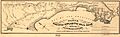
1851 map of a planned railroad between San Francisco and San Jose. Note Ravenswood, an earlier name of the Cooley Landing part of East Palo Alto, about midway on the coast.
-
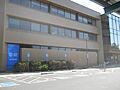
The East Palo Alto Municipal Building (2017), which includes City Hall and the library.

See also
 In Spanish: East Palo Alto para niños
