Calvert County, Maryland facts for kids
Quick facts for kids
Calvert County
|
|||
|---|---|---|---|

|
|||
|
|||

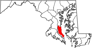
Location within the U.S. state of Maryland
|
|||
 Maryland's location within the U.S. |
|||
| Country | |||
| State | |||
| Founded | 1654 | ||
| Named for | Calvert family | ||
| Seat | Prince Frederick | ||
| Largest town | Chesapeake Beach | ||
| Area | |||
| • Total | 345 sq mi (890 km2) | ||
| • Land | 213 sq mi (550 km2) | ||
| • Water | 132 sq mi (340 km2) 38% | ||
| Population
(2020)
|
|||
| • Total | 92,783 |
||
| • Density | 435.60/sq mi (168.19/km2) | ||
| Time zone | UTC−5 (Eastern) | ||
| • Summer (DST) | UTC−4 (EDT) | ||
| Congressional district | 5th | ||
Calvert County is a county in the state of Maryland. It's located on the Calvert Peninsula, with the Chesapeake Bay to its east and the Patuxent River to its west. In 2020, about 92,783 people lived there.
The county seat, which is like its main town, is Prince Frederick. Calvert County was named after the Calvert family, who were the owners of the English Colony of Maryland. It's one of Maryland's oldest counties. Today, Calvert County is part of the larger Washington, D.C. area.
Contents
Exploring Calvert County's Past
Early European Settlers
In 1608, Captain John Smith was the first European to sail past Calvert County. He was exploring the Chesapeake Bay. His maps showed the Patuxent River and Native American villages. The area was mostly forests. The Patuxent people lived there and were peaceful with the first Europeans. They ate fish from the river and grew corn. They also hunted animals in the forests.
Early settlers wanted to use these clearings for farming. This sometimes caused problems with the Native Americans. In 1639, Leonard Calvert, Maryland's first Governor, sent armed men to protect the settlers.
The first written record of Europeans settling here was in 1642. It mentioned a Henry Bishop from St. Leonard's. This shows that people had been settling along the Patuxent River for a few years. By 1646, colonists had spread across the area. Most travel and trade happened by water. Large creeks were used by sailing boats. Plantations had docks to ship their goods. Ferry services were set up across the river and bay.
How Calvert County Got Its Name
The county was first called Charles County in 1650. It was much larger than the Charles County we know today. It was named after Charles I of England. The county seat was Calverton, located on Battle Creek.
In 1658, the county was renamed Calvert County. It even included parts of what are now Prince George's and Montgomery counties.
During a time of civil war in Britain, Puritans gained control. Many Puritans from Virginia settled in nearby Anne Arundel County and then moved into Calvert County. Lord Baltimore, who owned Maryland, required all new settlers to promise loyalty to him. This caused tension with the Puritan settlers.
In 1654, Lord Baltimore changed the county name back to Calvert County. But the Puritan government then renamed it Patuxent County that same year. They wanted to remove any connection to the Calvert family. The county kept the name Patuxent until 1658. Then, the name Calvert County was finally restored.
Life and Changes Over Time
In 1860, Calvert County had about 10,000 people. This included 4,609 enslaved people and 1,841 free people of color.
For a long time, the county was known for its farms and tobacco fields. But in the mid-1990s, tobacco prices dropped. Maryland started a program to help farmers switch to other crops. Many Calvert County farmers joined this program. Today, the county grows fruits, vegetables, and other crops. It also produces meat.
Calvert County has grown quickly. Many people who work in Washington, D.C. now live here. Home prices have increased a lot. Popular weekend towns like Solomons, Chesapeake Beach, and North Beach are well-known.
Many places in the county are listed on the National Register of Historic Places. These are important historical sites.
Exploring Calvert County's Nature
Calvert County covers about 345 square miles. About 213 square miles are land, and 132 square miles are water. This makes it the smallest county in Maryland by land area. It also has five islands: Solomons Island, Broomes Island, Buzzard Island, Hog Island, and Molly's Leg.
The county's coast along the Chesapeake Bay is a long, smooth curve. This is a special feature of the Chesapeake Bay.
Fossils at Calvert Cliffs
A special rock formation is named after the county: the Calvert Formation. You can see it at Calvert Cliffs State Park. These cliffs are famous for their fossils. People often find shark teeth, marine animal bones, and even crocodile teeth there. Finding crocodile teeth suggests that crocodiles might have nested in the sands when the formation was created.
The county's landscape has three main levels or "terraces." These terraces show times when the sea level rose and fell, leaving behind sand. The oldest terrace formed during the Miocene Age. At that time, the entire county peninsula was underwater. Marine deposits, clay, and mud with seashells and fossils were left behind. This is what we see at Calvert Cliffs today. These terraces are most clear on the Bay side of the county, where they rise up to 100 feet high.
Weather and Climate
Calvert County has a humid subtropical climate. This means it has hot, humid summers. Winters are mild to chilly, with plenty of rain or snow all year. Being close to the Chesapeake Bay helps keep temperatures more moderate. For example, the average temperature in Prince Frederick is about 35.9°F in January and 77.9°F in July.
Neighboring Counties
Calvert County shares borders with several other counties:
- Anne Arundel County (north)
- Prince George's County (northwest)
- Charles County (west)
- Dorchester County (east)
- Talbot County (northeast)
- St. Mary's County (south)
People of Calvert County
| Historical population | |||
|---|---|---|---|
| Census | Pop. | %± | |
| 1790 | 8,652 | — | |
| 1800 | 8,297 | −4.1% | |
| 1810 | 8,005 | −3.5% | |
| 1820 | 8,073 | 0.8% | |
| 1830 | 8,900 | 10.2% | |
| 1840 | 9,229 | 3.7% | |
| 1850 | 9,646 | 4.5% | |
| 1860 | 10,447 | 8.3% | |
| 1870 | 9,865 | −5.6% | |
| 1880 | 10,538 | 6.8% | |
| 1890 | 9,860 | −6.4% | |
| 1900 | 10,223 | 3.7% | |
| 1910 | 10,325 | 1.0% | |
| 1920 | 9,744 | −5.6% | |
| 1930 | 9,528 | −2.2% | |
| 1940 | 10,484 | 10.0% | |
| 1950 | 12,100 | 15.4% | |
| 1960 | 15,826 | 30.8% | |
| 1970 | 20,682 | 30.7% | |
| 1980 | 34,638 | 67.5% | |
| 1990 | 51,372 | 48.3% | |
| 2000 | 74,563 | 45.1% | |
| 2010 | 88,737 | 19.0% | |
| 2020 | 92,783 | 4.6% | |
| 2023 (est.) | 94,728 | 6.8% | |
| U.S. Decennial Census 1790–1960 1900–1990 1990–2000 2010–2018 |
|||
As of the 2010 United States Census, there were 88,737 people living in Calvert County. The population density was about 416 people per square mile. Most residents were white (81.4%), followed by Black or African American (13.4%). About 2.7% of the population was of Hispanic or Latino background.
The median income for a household in the county was $90,838. This means half of the households earned more and half earned less. The median income for a family was even higher, at $102,638.
Calvert County's Economy
Calvert County has several important businesses and facilities. The Calvert Cliffs Nuclear Power Plant is located in Lusby. This plant generates electricity. The Cove Point LNG Terminal is also there.
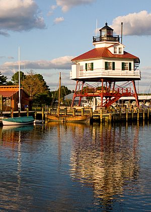
The Chesapeake Biological Laboratory is in Solomons. It's part of the University of Maryland Center for Environmental Science. A branch of the United States Naval Research Laboratory is in Chesapeake Beach. The Patuxent River Naval Air Station is just south of the county.
Major Employers
Here are some of the top employers in Calvert County:
- Calvert County Public Schools (schools)
- Calvert County Government (local government)
- Calvert Memorial Hospital (healthcare)
- Constellation (energy)
- Walmart (retail)
- Giant Food (grocery)
- Arc of Southern Maryland (support services)
- Chesapeake Beach Resort & Spa (hospitality)
- Safeway (grocery)
Learning in Calvert County
Calvert County is served by Calvert County Public Schools. The school system has 13 elementary schools, six middle schools, and four high schools. There is also a vocational education center. This center helps students learn job skills.
The Calverton School is a private school for grades K-12. Cardinal Hickey Academy is a private Catholic school for Pre-K through 8th grade.
Getting Around Calvert County
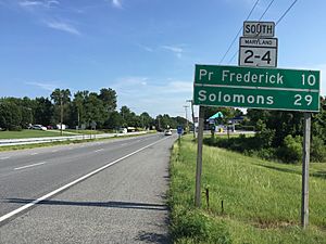
The main road in Calvert County is Maryland Route 4. It starts in Washington, D.C. as Pennsylvania Avenue. Route 4 enters Calvert County near Dunkirk. In Sunderland, Route 4 joins Maryland Route 2. They become Maryland Route 2–4. This combined road goes south through Prince Frederick, St. Leonard, and Lusby.
In Solomons, Routes 2 and 4 split. Route 2 goes into downtown Solomons. Route 4 crosses the Patuxent River on the Governor Thomas Johnson Bridge into St. Mary's County.
Route 2-4 is also called Solomons Island Road. The part south of Prince Frederick is named Louis Goldstein Highway. This honors Louis L. Goldstein, a former Maryland official from Calvert County.
In the 1970s and 1980s, Route 2-4 was made wider. It changed from two lanes to a four-lane highway. Some parts of the old road became Maryland Route 765. The last part of the wider Route 2-4 was finished in 1988. In 2009, a section in Prince Frederick was expanded to three lanes. Sidewalks were also added.
Other important roads in Calvert County include:
- Maryland Route 231: This road goes west from Prince Frederick to the Patuxent River. It crosses the river on the Benedict Bridge into Charles County.
- Maryland Route 260: This road starts at the Calvert-Anne Arundel border. It travels southeast to Chesapeake Beach. Part of Route 260 is a four-lane highway.
Communities in Calvert County
Towns
Census-Designated Places
These are areas the Census Bureau defines for statistics. They are not officially incorporated towns.
Some of these places, like Dunkirk and Prince Frederick, are called "town centers" by the county government. This means they have special boundaries for planning and development. The idea is to build new homes and businesses in existing areas. This helps protect the county's rural and farm areas. This "town center" idea has been successful in Calvert County. It is a good example of smart growth planning.
Unincorporated Communities
These are smaller communities that are not officially towns or census-designated places.
Famous People from Calvert County
Many notable people have connections to Calvert County:
- Louisa Adams: A First Lady of the United States, married to President John Quincy Adams.
- Charles Ball: An enslaved man known for his journey to freedom and his autobiography.
- Harriet Elizabeth Brown: A school teacher who fought for equal pay for teachers in Maryland.
- Brett Cecil: A professional baseball pitcher.
- Tom Clancy: A famous author.
- Louis L. Goldstein: A former Comptroller of Maryland, a top financial officer for the state.
- Thomas Johnson: Maryland's first elected governor and a Supreme Court Justice.
- Robert McClain: A professional football player.
- Roger Brooke Taney: A Chief Justice of the United States, known for the Dred Scott decision.
- Margaret Taylor: A First Lady of the United States, married to President Zachary Taylor.
- Wax: A rapper, singer, and musician.
- Judy Woodruff: A well-known news anchor and journalist.
Images for kids
See also
 In Spanish: Condado de Calvert para niños


