
Candeleda facts for kids
Quick facts for kids
Candeleda
|
|||
|---|---|---|---|

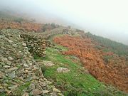
View of Candeleda
|
|||
|
|||

Candeleda
Location in Castile and León

Candeleda
Location in Spain
|
|||
| Country | |||
| Autonomous community | |||
| Province | |||
| Area | |||
| • Total | 215.52 km2 (83.21 sq mi) | ||
| Elevation | 428 m (1,404 ft) | ||
| Population
(2018)
|
|||
| • Total | 4,998 | ||
| • Density | 23.1904/km2 (60.063/sq mi) | ||
| Time zone | UTC+1 (CET) | ||
| • Summer (DST) | UTC+2 (CEST) | ||


Candeleda is a town and municipality in Ávila province, Castile and León, Spain. About 5,000 people live here, making it one of the largest towns in the province. Candeleda is located on the southern side of the Sierra de Gredos mountains. This special location gives it a unique climate. Winters are mild, and summers are hot, with average temperatures around 26°C.
The town has strong ties with nearby places like Arenas de San Pedro and the Tiétar valley. It also connects with areas in Extremadura and Castile-La Mancha. Candeleda celebrates its main festival every year in September. This festival honors the town's patron saint, the Virgin of Chilla.
Contents
Town Symbols
Coat of Arms
Candeleda has its own special coat of arms. It shows a golden castle with three towers on a blue background. The middle tower is taller than the others. Around the edge, there's a pattern of silver and red squares. Another part of the shield shows a black ribbon with a gold chain on a silver background. The third part has a silver chapel and an oak tree on a green field. A Spanish Royal Crown sits on top of the shield.
Flag
The flag of Candeleda is square. It is a deep red, or crimson, color. In the very center of the flag, you can see the municipal coat of arms in all its colors.
Name and People
The name Candeleda likely comes from the Latin word "Candela." This word refers to the blossoms of chestnut trees or holm oaks, which are common in the area. The ending "-etum" means "a place of abundance." So, Candeleda means a place with many chestnut or holm oak blossoms. People from Candeleda are called Candeledanos.
Where is Candeleda?
Location Details
Candeleda is in the southwest part of the Sierra de Gredos mountains. It's in the Ávila province. The municipality shares borders with Cáceres (in Extremadura) and Toledo (in Castile-La Mancha). It is about 101 kilometers (63 miles) from Ávila, the capital city of the province. The closest bigger cities are Talavera de la Reina (61 km away) and Plasencia (120 km away). The land in Candeleda varies a lot in height. It goes from 252 meters (827 feet) near the Rosarito reservoir to 2592 meters (8,504 feet) at the top of Pico Almanzor. This peak is the highest point in the Central System mountains.
 |
Bohoyo | Zapardiel de la Ribera and Navalperal de Tormes | San Juan de Gredos and Arenas de San Pedro | |
| Madrigal de la Vera | Poyales del Hoyo and Arenas de San Pedro | |||
| Oropesa (Toledo) | Oropesa (Toledo), Calzada de Oropesa (Toledo) and Lagartera (Toledo) | Oropesa (Toledo) and Arenas de San Pedro |
Rivers and Water

The Tiétar river flows along the southern edge of the municipality. This river forms the border with the province of Toledo. Several smaller rivers, called gorges, flow down from the Sierra de Gredos mountains. These gorges, like Santa Maria, Chilla, and Alardos, join the Tiétar river.
The Rosarito reservoir is a large lake that holds water from the Tiétar River. It is located between the provinces of Ávila and Toledo. This reservoir was built in 1958. It is used to supply water, generate electricity, and for fun activities like boating. It can hold 82 cubic hectometers of water.
Climate
Candeleda has different climate zones because its land varies so much in height. In the main town area, which is 428 meters (1,404 feet) high, the climate is Mediterranean. This means it has mild winters and hot summers. The average summer temperature is about 26°C (79°F). The highest parts of the Sierra de Gredos mountains, like Pico Almanzor, have a cooler, more continental climate. Candeleda gets a lot of rain because it is located south of the Gredos mountain range.
| Climate data for Candeleda | |||||||||||||
|---|---|---|---|---|---|---|---|---|---|---|---|---|---|
| Month | Jan | Feb | Mar | Apr | May | Jun | Jul | Aug | Sep | Oct | Nov | Dec | Year |
| Daily mean °C (°F) | 7.90 (46.22) |
9.20 (48.56) |
11.80 (53.24) |
14.30 (57.74) |
18.00 (64.40) |
22.90 (73.22) |
26.40 (79.52) |
25.90 (78.62) |
23.50 (74.30) |
17.50 (63.50) |
11.50 (52.70) |
7.90 (46.22) |
16.40 (61.52) |
| Average precipitation mm (inches) | 157.70 (6.21) |
151.10 (5.95) |
75.90 (2.99) |
87.90 (3.46) |
84.60 (3.33) |
37.90 (1.49) |
10.40 (0.41) |
12.50 (0.49) |
41.40 (1.63) |
100.20 (3.94) |
127.40 (5.02) |
169.10 (6.66) |
1,056.1 (41.58) |
| Source: Ministerio de Agricultura, Alimentación y Medio Ambiente. Datos de precipitación para el periodo 1967-1987 y de temperatura para el periodo 1961-1987 en Candeleda | |||||||||||||
Plants and Animals
Candeleda's varied altitudes mean it has many different types of plants. You can find many chestnut trees, Pyrenean oaks, and maritime pines in the middle parts of the area. Lower down, there are lots of holm oaks and cork oaks. The flatter areas are best for farming.
El Raso Village
El Raso is a village that belongs to Candeleda. It is located about 10 kilometers (6 miles) west of the main town. The village is 720 meters (2,362 feet) above sea level. In 2011, El Raso had 482 people living there. It was started in 1934 for raising goats on the southern slopes of the Sierra de Gredos. Today, El Raso is still known for goat farming and agriculture. It is also a popular spot for rural tourism. The village celebrates its annual festival on July 25th, honoring its patron saint, St. James. The festival includes heifers, fire bulls, and traditional dances.
Population
In 2011, Candeleda had 5,213 residents. About 24% of the people were over 64 years old. There were 239 residents (about 4.6% of the total) who came from other countries. Most of these foreign residents were from Romania (91 people) and Colombia (20 people). In total, 101 people came from South America.
| 2001 | 2003 | 2005 | 2007 | 2009 | 2011 |
|---|---|---|---|---|---|
| 5109 | 5026 | 5047 | 5123 | 5166 | 5213 |
| Population entity | Inhabitants |
|---|---|
| Candeleda | 4.484 |
| El Raso | 482 |
| *Scattered* | 247 |
| Source: Caja España: Ficha Municipal de Candeleda. Datos de 2011, Google Earth. | |
Economy and Jobs
Candeleda's economy mostly depends on the tertiary sector, which includes services like tourism. In 2011, over half of the workers (56.3%) were in this sector. Tourism is very important for the town.
Farming and Livestock
About 19.9% of working people were in the primary sector in 2007. This includes farming and raising animals. A large part of the farmland (64.2%) is used for pastures where animals graze. There are also many olive groves and orchards.
Raising animals is very important here. Candeleda has the most goats in the entire province of Ávila. About 22,000 goats provide jobs for 130 families. They produce fresh, cured, and semi-cured goat's cheese. The area is also known for "Carne de Ávila," which is beef from a special local type of cow.
Tourism and Services
The tertiary sector is the biggest part of Candeleda's economy. It employs most of the working population. Tourism is a huge part of this. In 2011, the municipality had many shops, restaurants, and hotels.
Rural tourism has grown very fast in recent years. Many visitors, especially from Madrid, come to the Tiétar Valley region. Candeleda offers places for tourists to stay, like hotels and cottages. Many companies in the area offer activities like horse riding, summer camps, and caravan parks. Many people also own second homes in the region, which helps the local economy.
Community Facilities

Education
For young children, Candeleda has the Almanzor Public Primary School in the town. El Raso village has its own Vetonia Primary School. Older students attend Candavera High school for Secondary education.
Library and Auditorium
Candeleda has a municipal library with two floors. The first floor is for studying, and the second is a children's room. It opened in 1993. The town also has a municipal auditorium that opened in 2010. It has a main room with 310 seats and two smaller rooms for rehearsals.
Sports
Candeleda has a small indoor sports arena. It is used for basketball and five-a-side football. There is also a municipal football ground called "El Llano" west of the village. It can seat about 500 people. Next to the stadium, there is a municipal campsite with a heated swimming pool. Candeleda also has a golf course that is open all year round.
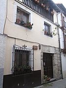
Historic Buildings
Candeleda has several important historic buildings:
- Castro Celta de El Raso: This is an ancient Celtic fort.
- The shrine of Our Lady of Chilla: A special religious building.
- The church of Our Lady of the Assumption: A beautiful church in the town.
- The San Blas hermitage: Another religious building, a small chapel.
- The Pillory: A historic stone pillar that was once used for public punishments.
-
Castro Celta de El Raso wall
-
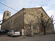
Church of Our Lady of the Assumption
-
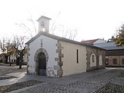
Saint Blaise's Hermitage
-
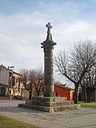
Candeleda's Pillory


Places to Visit
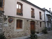
- Ethnographic Museum: This museum shows the history and culture of Candeleda. It has items donated by local people, including old tools and a 16th-century coat of arms. It opened in 2012.
- Casa de la Judería (Jewry's House): This small museum shares the history, culture, and traditional food of Candeleda. It displays paintings, photos, and sculptures. It opened in 2010.
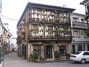
- Tin Toy Museum House of Flowers: This museum has over 2,000 tin toys! It is located in a striking traditional building in the town's Main Square.
- Vado de los Fresnos: This is an animal reserve. You can see many local animal species living near the Rosarito reservoir.
-
Ethnographic Museum
-
Casa de la Judería
-
House of Flowers, Tin Toy Museum home


Festivals and Traditions
The main festival in Candeleda honors the Virgin of Chilla. It takes place on the second and third Sundays of September. This event is so important that it has been named a Fiesta of National Tourist Interest.
Other traditions include "Las Candelas" on February 2nd. Young people jump over bonfires called "iluminarias." The next day, February 3rd, is Saint Blaise Day, also known as chorizo day. People gather to eat Spanish donuts and chorizo from local farms.
Candeleda also has old traditions like rondas. These are informal groups of friends and neighbors who sing, play music, and dance in the street. They use instruments like guitars, lutes, and even kitchen items like cauldrons and mortars. At Christmas, they use zambombas (rustic drums). Traditional music styles like rondeñas, malagueñas, and jotas are still popular for dancing. The Pedro Vaquero Festival of folk music is held every August.
Local Food

Candeleda's food is similar to other parts of its province. However, it also has special dishes because it is close to Extremadura and La Vera. One very famous product grown here is Candeleda paprika. It is like the paprika from the nearby La Vera region, which has a special "designation of origin" (meaning it's a protected local product).
This paprika is used to flavor many traditional Spanish dishes. You might find it in "Riojan potatoes," "Galizian octopus," "patatas bravas," and chorizo.
Famous People from Candeleda

- Tristan Garel-Jones (1941-2020): He was a Conservative politician from the United Kingdom. He used to be the Foreign Secretary and owned a house in Candeleda.
- John Major (born 1943): He was a former Prime Minister of the United Kingdom. He has spent several summers in Candeleda since the late 1980s, visiting the home of his friend Tristan Garel-Jones.
See also
 In Spanish: Candeleda para niños
