
Caracas facts for kids
Caracas, officially known as Santiago de León de Caracas, is the exciting capital and largest city of Venezuela. It's also the main hub of the Metropolitan Region of Caracas, often called Greater Caracas. This big city is nestled in the Caracas Valley, right along the Guaire River in the northern part of the country.
Imagine a city surrounded by mountains! Caracas is close to the Caribbean Sea, but a tall mountain range, Cerro El Ávila, separates it from the coast. To the south, there are even more hills and mountains. The Greater Caracas area is home to nearly 5 million people!
The heart of the city is usually considered to be near Bolívar Square, though some people think Plaza Venezuela is the true center. Caracas has a lot of businesses, especially service companies, banks, and shopping malls. It's known for its service-based economy, meaning many jobs are in areas like finance, trade, and tourism. Big companies like the Caracas Stock Exchange and Petróleos de Venezuela (PDVSA), which handles oil, have their main offices here. Caracas is also Venezuela's cultural capital, full of amazing restaurants, theaters, museums, and places to shop. You can even see some of the tallest skyscrapers in Latin America here, like the Parque Central Towers. The Museum of Contemporary Art of Caracas is one of the most important art museums in South America.
Quick facts for kids
Caracas
|
|||
|---|---|---|---|
| Santiago de León de Caracas | |||
|
(From top, left to right) Plaza Venezuela; Plaza Francia; Parque Cristal in Los Palos Grandes; Nuestra Señora de Lourdes Church; Parque Central Complex
|
|||
|
|||
| Nicknames:
La Sucursal del Cielo
La Ciudad de la Eterna Primavera La Odalisca del Ávila La Sultana del Ávila |
|||
| Motto(s):
Seguid El Ejemplo Que Caracas Dio. (Then Follow the Example that Caracas Gave.)
|
|||
.jpg)
Caracas
Location in Venezuela
|
|||
| Country | Venezuela | ||
| State | Capital District | ||
| Founded | 25 July 1567 | ||
| Founded by | Diego de Losada | ||
| Government | |||
| • Type | Mayor–council | ||
| • Body | Government of the Capital District | ||
| Area | |||
| • Capital city | 433 km2 (167 sq mi) | ||
| • Metro | 4,715.1 km2 (1,820.5 sq mi) | ||
| Elevation | 900 m (3,000 ft) | ||
| Highest elevation | 1,400 m (4,600 ft) | ||
| Lowest elevation | 870 m (2,850 ft) | ||
| Population
(2022)
|
|||
| • Capital city | 3,242,000 | ||
| • Metro | 5,297,026 | ||
| Demonyms | Caraquenian (Spanish: caraqueño (m), caraqueña (f)) | ||
| Time zone | UTC−04:00 (Venezuela Standard Time) | ||
| • Summer (DST) | (Not Observed) | ||
| Postal codes |
1000–1090, 1209
|
||
| Area code | 212 | ||
| ISO 3166 code | VE-A | ||
| The area and population figures are the sum of the figures of the five municipalities (listed above) that make up the Distrito Metropolitano. | |||


.svg)
.png)
Contents
History of Caracas

Before Caracas was founded, the valley was home to many native groups. In the mid-1500s, a Spanish captain's son, Francisco Fajardo, tried to set up settlements. But these early attempts were destroyed by local native leaders like Terepaima and Guaicaipuro.
Finally, on July 25, 1567, Captain Diego de Losada officially founded the city. He named it Santiago de León de Caracas. The city was built close to the coast, which helped it become a trading center. Farmers in Caracas grew wheat and later discovered that Cacao beans could be sold. This made the city very important for trade in the Spanish Empire.
During the 16th and 17th centuries, pirates often attacked the Venezuelan coast. But Caracas was somewhat safe because of the mountains. However, in 1595, English privateers, including Amyas Preston, found a secret path and attacked the city. They burned parts of it after a ransom deal failed. Caracas rebuilt itself and continued to grow, especially with the cacao trade.

In 1728, a special company was created to boost the cacao business. Caracas became the capital of the Spanish Empire's Venezuela Province in 1777. Venezuela then fought for its freedom from Spain. The Venezuelan Declaration of Independence happened in 1811. However, a big earthquake destroyed Caracas in 1812. The Venezuelan War of Independence continued until 1821, when Simón Bolívar won a major battle.
Caracas really started to grow and modernize in the 20th century, especially during Venezuela's oil boom. In the 1950s, the city began a huge building program. Many public buildings were constructed, like the University City of Caracas, which is now a UNESCO World Heritage Site. The Caracas Metro subway system was also built. This fast growth led to some informal settlements on the hillsides. Today, the city faces ongoing economic and social challenges.
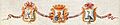
Caracas Coat of Arms
The coat of arms for Caracas was officially adopted in 1591. It was granted by King Philip II. The coat of arms shows a red Santiago (St. James') cross, which represents the city's name. It also features a brown bear holding a golden shell with the red cross.
The city's anthem is called Marcha a Caracas. It was written by Tiero Pezzuti de Matteis with lyrics by José Enrique Sarabia and approved in 1984.
.jpg)
Geography of Caracas

Caracas is located in a valley within the Venezuelan Central Range. It's separated from the Caribbean coast by about 15 kilometers of El Ávila National Park. The valley is quite small and uneven. The city's elevation changes, but the historic center is about 900 meters (2,950 feet) above sea level. The highest point in the area is Pico El Ávila, which is 2,159 meters (7,083 feet) high.
The main river in Caracas is the Guaire River. It flows through the city and joins the Tuy River. Other smaller rivers and streams also feed into it. The La Mariposa and Camatagua reservoirs provide water to the city. Caracas can sometimes experience earthquakes, like the notable ones in 1641 and 1967.
Geologically, Caracas was formed a long time ago, during the Late Cretaceous period. The land here is mostly made of metamorphic rock.
Climate in Caracas

Caracas has a tropical savanna climate, but because it's high up in the mountains, it also feels like a subtropical highland climate. This means temperatures are cooler than in other tropical places. The city gets between 900 and 1,300 millimeters (35 to 51 inches) of rain each year.
The average temperature is about 23.4°C (74.1°F). The coldest month is January, averaging 21.7°C (71.1°F), and the warmest is May, averaging 24.5°C (76.1°F). This shows that the temperature doesn't change much throughout the year.
In December and January, it can get foggy, and temperatures drop at night, sometimes reaching 8°C (46°F). This cool weather is known as the Pacheco by locals. Even at other times of the year, nights are much cooler than days, making evenings very pleasant. Thunderstorms are common, especially from June to October, because the city is in a valley surrounded by mountains.
| Climate data for Caracas, Venezuela (La Carlota) (1991-2020 normals, extremes 1964-2020) | |||||||||||||
|---|---|---|---|---|---|---|---|---|---|---|---|---|---|
| Month | Jan | Feb | Mar | Apr | May | Jun | Jul | Aug | Sep | Oct | Nov | Dec | Year |
| Record high °C (°F) | 33.8 (92.8) |
34.4 (93.9) |
35.3 (95.5) |
35.8 (96.4) |
35.8 (96.4) |
35.3 (95.5) |
34.4 (93.9) |
34.4 (93.9) |
37.1 (98.8) |
34.5 (94.1) |
34.8 (94.6) |
31.9 (89.4) |
37.1 (98.8) |
| Mean daily maximum °C (°F) | 27.1 (80.8) |
27.6 (81.7) |
28.6 (83.5) |
29.3 (84.7) |
29.4 (84.9) |
28.5 (83.3) |
28.0 (82.4) |
28.3 (82.9) |
28.8 (83.8) |
28.6 (83.5) |
28.1 (82.6) |
27.1 (80.8) |
28.3 (82.9) |
| Daily mean °C (°F) | 21.7 (71.1) |
22.1 (71.8) |
23.1 (73.6) |
24.1 (75.4) |
24.5 (76.1) |
24.1 (75.4) |
23.5 (74.3) |
23.7 (74.7) |
24.3 (75.7) |
24.1 (75.4) |
23.5 (74.3) |
22.3 (72.1) |
23.4 (74.1) |
| Mean daily minimum °C (°F) | 17.3 (63.1) |
17.7 (63.9) |
18.5 (65.3) |
20.0 (68.0) |
21.2 (70.2) |
21.0 (69.8) |
20.5 (68.9) |
20.8 (69.4) |
20.9 (69.6) |
20.8 (69.4) |
20.3 (68.5) |
18.6 (65.5) |
19.8 (67.6) |
| Record low °C (°F) | 10.0 (50.0) |
6.0 (42.8) |
5.1 (41.2) |
12.5 (54.5) |
13.1 (55.6) |
14.9 (58.8) |
14.1 (57.4) |
14.3 (57.7) |
15.5 (59.9) |
13.1 (55.6) |
11.9 (53.4) |
10.0 (50.0) |
5.1 (41.2) |
| Average precipitation mm (inches) | 56.1 (2.21) |
42.5 (1.67) |
20.7 (0.81) |
48.1 (1.89) |
70.2 (2.76) |
112.6 (4.43) |
121.1 (4.77) |
132.7 (5.22) |
118.4 (4.66) |
144.3 (5.68) |
130.0 (5.12) |
107.4 (4.23) |
1,104.1 (43.45) |
| Average precipitation days (≥ 1 mm) | 3.9 | 2.9 | 2.2 | 4.3 | 7.1 | 11.0 | 12.7 | 12.2 | 9.4 | 11.1 | 8.7 | 7.0 | 92.5 |
| Average relative humidity (%) | 78 | 76 | 74 | 76 | 78 | 80 | 80 | 81 | 82 | 80 | 82 | 81 | 79 |
| Mean monthly sunshine hours | 229.4 | 215.6 | 235.6 | 183.0 | 182.9 | 183.0 | 210.8 | 217.0 | 213.0 | 210.8 | 210.0 | 213.9 | 2,505 |
| Source: NOAA (humidity and sun 1964-1990) | |||||||||||||
Rivers and Water in Caracas
The main water system in Caracas is the Guaire River basin. This river flows through the city from west to east. It covers about 655 square kilometers (253 square miles). The basin is shaped by the Caracas Valley, which is narrow and long, surrounded by tall mountains.
Unfortunately, the lower parts of the Guaire River have become very polluted over time. This pollution started in 1874 and has continued. It means that many of the animals and plants that used to live in the river are gone or only found in the higher, cleaner areas near the Ávila National Park. People are now working to clean up the river, but it will take a lot of effort.
Some important rivers and streams that flow into the Guaire River from the north include the San Pedro River and the Catuche River. From the south, you'll find the El Valle River. There are also two reservoirs, Macarao Dam and La Mariposa Reservoir, which supply water to the city.
Urban Development in Caracas

Caracas is like many other cities in Latin America. It's very crowded and doesn't have much flat space because it's surrounded by mountains. This means the city has grown "upwards" with many tall buildings. You'll also see many homes built on the mountain slopes around the city. These are often built without official plans and with simple materials.
The city center is quite old, but it's less than a quarter of the city's total area. Caracas has spread out along the valley and now connects with nearby towns. This creates a huge metropolitan area called Gran Caracas. Because so many people live here, traffic can be very bad. To help with this, the city has expanded its subway system, the Metro de Caracas. It also connects to other train systems.
Some parts of the city have a neat grid pattern, like a checkerboard. This was either planned long ago or built during modern city projects. Other areas, especially on the mountain slopes, follow the shape of the land. These higher areas often have cooler temperatures all year round.
People of Caracas

Caracas is a very diverse city! In 2011, the city itself had over 1.9 million people. The larger Metropolitan District of Caracas had about 2.9 million people. Most of the people are of mixed heritage, meaning they have ancestors from Europe, Indigenous groups, Africa, and sometimes Asia. There's also a notable Afro-Venezuelan community.
The city is home to many people whose families came from Europe and Asia during the 20th century. These include descendants of people from Spain, Portugal, Italy, China, Colombia, Germany, Syria, and Lebanon. This mix of cultures and backgrounds has made Caracas a truly unique place throughout its history.
Because of its fast growth, Caracas has expanded beyond its original borders. The Metropolitan District of Caracas is a better way to study its population. This area, though less than 1% of Venezuela's land, is home to about one-fifteenth of the country's total population.
In the 20th century, many people moved from rural areas to Caracas and other cities looking for a better life. This caused the city to grow very quickly. Between the 1940s and 1950s, after World War II, many immigrants from Spain, Portugal, and Italy came to Caracas. Later, in the 1960s, more people arrived from other parts of Latin America and the world, including Argentines, Uruguayans, Chileans, and Chinese. This continued until the late 1980s, with many Colombians also moving to the city.
Economy of Caracas

Caracas is a major economic center in Venezuela. Many businesses, including service companies, banks, and shopping malls, are located here. The city's economy is mostly based on services, though there is some industrial activity in the surrounding areas.
The Caracas Stock Exchange and Petróleos de Venezuela (PDVSA) have their main offices in Caracas. PDVSA is a state-run oil company and the largest company in Venezuela. It handles all international agreements for selling and exporting oil.
Many international companies and embassies are also found in areas like El Rosal and Las Mercedes. Caracas is also a key hub for communication and transportation for the rest of the country. Important industries in the city include chemicals, textiles, leather, food, iron, and wood products. There are also factories for rubber and cement.
In 2009, a United Nations survey found that the cost of living in Caracas was about 89% of that in New York City. However, this number might not be completely accurate today due to changes in currency exchange rates and inflation.
Tourism in Caracas
Attracting foreign visitors has been a challenge for Venezuela. In 2013, the World Economic Forum ranked Venezuela very low in its efforts to bring in tourists. One big reason for this is the limited transportation options for tourists, like few railway systems and airlines.
To try and attract more visitors, the Venezuelan Ministry of Tourism has invested in hotels. The largest hotel investment has been in the Hotel Alba Caracas. However, the government hasn't made tourism a top economic priority. In 2013, the tourism ministry's budget was much smaller than that of other ministries. Tourism contributes about 3.8% to Venezuela's economy. Experts predict this could rise to 4.2% by 2022.
Culture in Caracas

Caracas is known as Venezuela's cultural capital. It has many restaurants, theaters, museums, and shopping centers. The city is also a melting pot of cultures, with many people from Spain, Italy, Portugal, the Middle East, Germany, China, and other Latin American countries.
Music in Caracas
The Simón Bolívar Symphony Orchestra is based in Caracas. This orchestra started as a youth orchestra and is part of a special music program called El Sistema. This program helps young people through music. The Guardian newspaper said the orchestra shows "a message of social inclusion and the manifest power of music to bring communities together."
Sports in Caracas
Caracas is home to several professional sports teams. In football, there are clubs like Caracas Fútbol Club and Deportivo Petare. Deportivo Petare has even reached the semi-finals of international tournaments like the Copa Libertadores.
For baseball fans, the Leones del Caracas team plays at the Monumental Stadium, which can hold 40,000 spectators. The Tiburones de La Guaira team plays at University Stadium.
Football stadiums include the Olympic Stadium, which holds 30,000 people, and the Brígido Iriarte Stadium, with a capacity of 12,000. In basketball, the Cocodrilos de Caracas play at the Gimnasio José Beracasa.
Caracas is also where the National Institute of Sports and the Venezuelan Olympic Committee are located. The city hosted the 1983 Pan American Games.
Education in Caracas

Central University of Venezuela
The Central University of Venezuela (Universidad Central de Venezuela, UCV) is a public university. It was founded in 1721, making it the oldest university in Venezuela. The university's campus was designed by architect Carlos Raúl Villanueva. It was recognized as a UNESCO World Heritage Site in 2000.
Simón Bolívar University
The Simón Bolívar University (Universidad Simón Bolívar, USB) is another public university in Caracas. It focuses on science and technology.
Other Universities in Caracas
- Bolivarian Military University of Venezuela (Main Campus)
- Universidad Católica Andrés Bello
- Universidad Nacional Experimental de la Gran Caracas
- Universidad Metropolitana
- Universidad Nacional Experimental de las Artes (UNEARTE)
- Universidad Monteávila
- Universidad Nueva Esparta
- Universidad Santa Maria
- Universidad Alejandro de Humboldt
- Universidad Nacional Experimental de las Fuerzas Armadas
- Universidad Nacional Experimental Simón Rodríguez
- Universidad Bolivariana de Venezuela
- Universidad José María Vargas
- Universidad Pedagógica Experimental Libertador
- Universidad Experimental Politécnica Antonio José de Sucre
International Schools in Caracas
- British School of Caracas
- Colegio Internacional de Caracas
- Escuela Campo Alegre
- International Christian School
- Tomchei Tmimim
- Lycée Français de Caracas – Colegio Francia
Transportation in Caracas

The Caracas Metro is a very important way to get around the city. It has been running since March 27, 1983. It has four lines and 47 stations, with more planned for the future. The Metro covers a large part of the city and has a special ticket system that lets you use both the subway and the Metrobús, which is a bus service connected to the Metro. In 2010, a new cable car system called Metrocable opened, which connects to the larger metro system.
Buses are the main way many people travel in Caracas. There are two bus systems: the traditional one and the Metrobús. Other ways to travel include the IFE train, which goes to and from towns in the Tuy Valley. The Simón Bolívar International Airport is the country's largest and most important airport. There are also additional metro services like the Caracas Aerial Tramway and the Los Teques Metro, which connects Caracas to the nearby city of Los Teques.
Highways and Main Roads
Caracas and its surrounding areas have the largest network of roads in Venezuela. There are many highways and avenues in the city. This road network is a big connection point for travel between the west, east, and center of the country. However, this also means that traffic in Caracas is very congested. It's the city with the most cars in Venezuela, leading to traffic jams at almost any time, especially during rush hour. People in Caracas can sometimes spend up to 3 hours stuck in traffic.
A new highway is being built to help reduce traffic in Caracas. It will connect two major highways, allowing vehicles to travel from east to west (or vice versa) without having to go through the city center.
Caracas Metro System

The Caracas Metro is one of the most important ways to get around the city. Its 47 stations transport about 2 million people every day. The Metro system covers the central part of the city from east to west. It also has lines that connect to the southwest and other Metro systems like BusCaracas and Metrocable. There are also plans to expand the metro to other towns like Guarenas and Guatire.
The system opened in 1983 and has 71 kilometers (44 miles) of track with five lines. This makes it one of the longest subway systems in Latin America. An extension to the city of Los Teques is also part of the system.
BusCaracas
BusCaracas is a special bus system that connects certain areas of Caracas. It started operating in October 2012. It's designed like other modern transit systems. BusCaracas has 11 stations and connects to the subway system at two stations: La Hoyada and La Bandera.
Metrocable

The Caracas Metrocable is a cable car system that is part of the Caracas Metro. It was built so that people living in neighborhoods on the mountainsides can travel faster and safer to the city center. It works like a feeder route, bringing people to the main metro lines.
In 2011, a new Metrocable system was built in the San Agustín del Sur area. People can ride it and enjoy amazing views of a large part of Caracas.
Rail System
There is a national railway project in Venezuela that aims to connect Caracas with the central part of the country. Currently, the Caracas-Cúa train service is running. It's part of the Central Railway System of Venezuela. This train line connects Caracas with towns in the Valles del Tuy area, like Charallave and Cúa. The line is 41.4 kilometers (25.7 miles) long.
The train journey starts at the Libertador Simón Bolivar station in Caracas, which is connected to Line 3 of the Caracas metro. From there, it connects to three other stations in Charallave and ends at the Cúa General Ezequiel Zamora station.
Famous People from Caracas
Caracas and Other Cities
Twin Towns – Sister Cities
Caracas has special connections, called "twin towns" or "sister cities," with these places:
 A Coruña, Spain
- Adeje, Spain
 Honolulu, United States
- Madrid, Spain
- Melilla, Spain
- New Orleans, United States
 Panama City, Panama
 Rosario, Argentina
 Rio de Janeiro, Brazil
- Santa Cruz de Tenerife, Spain
 Santo Domingo, Dominican Republic
 Tehran, Iran
- Vigo, Spain
Union of Ibero-American Capital Cities
Caracas is also part of the Union of Ibero-American Capital Cities. This group connects capital cities in countries that speak Spanish or Portuguese. Caracas joined on October 12, 1982.
Images for kids
-
In the center, the (colonial) coat of arms of Caracas. On its left, a shield representing 'Justice', and on the right, 'Vigilance'. c. 1775, by Joseph Carlos de Aguero. General Archive of the Indies, Seville.
See also
 In Spanish: Caracas para niños
