Centre, Alabama facts for kids
Quick facts for kids
Centre
|
||
|---|---|---|

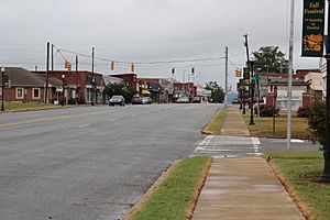
Downtown Centre
|
||
|
||

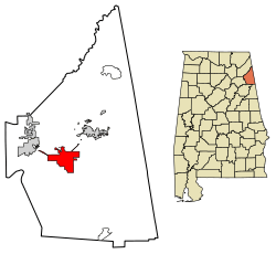
Location of Centre in Cherokee County, Alabama.
|
||
| Country | United States | |
| State | Alabama | |
| County | Cherokee | |
| Government | ||
| • Type | Mayor/Council | |
| Area | ||
| • Total | 11.76 sq mi (30.45 km2) | |
| • Land | 11.70 sq mi (30.31 km2) | |
| • Water | 0.05 sq mi (0.14 km2) | |
| Elevation | 663 ft (202 m) | |
| Population
(2020)
|
||
| • Total | 3,587 | |
| • Density | 306.50/sq mi (118.34/km2) | |
| Time zone | UTC-6 (Central (CST)) | |
| • Summer (DST) | UTC-5 (CDT) | |
| ZIP code |
35960
|
|
| Area code(s) | 256 | |
| FIPS code | 01-13648 | |
| GNIS feature ID | 0115902 | |
Centre is a city in Cherokee County, Alabama, in the United States. It is the main town, also called the county seat, of Cherokee County. In 2020, about 3,587 people lived there.
Contents
History of Centre
Cherokee County was created on January 9, 1836. It was named after the Cherokee people who used to live in this area. A famous Cherokee chief named Pathkiller lived nearby in a place called Turkeytown.
When the county was first made, the main town was Cedar Bluff. But in 1844, the county seat was moved to Centre. This new town was chosen because it was more in the middle of the county. That's why it's called "Centre," using the British English spelling. In 2011, Centre started allowing the sale of alcoholic drinks.
Geography of Centre
Centre is located a bit west of the middle of Cherokee County. Its exact spot is 34°9'33.052" North and 85°40'29.071" West. The northern edge of the city reaches the southern shore of Weiss Lake, which is on the Coosa River.
Major roads like U.S. Route 411 and Alabama State Route 68 go around the north side of the city. US-411 goes east about 22 miles (35 km) to Cave Spring, Georgia. It also goes northwest about 5 miles (8 km) to Leesburg. Alabama State Route 9 runs through Centre. It goes northeast about 6 miles (10 km) to Cedar Bluff and south about 18 miles (29 km) to Piedmont.
The city covers a total area of about 11.76 square miles (30.45 square kilometers). Most of this area, about 11.70 square miles (30.31 square kilometers), is land. A small part, about 0.05 square miles (0.14 square kilometers), is water.
Centre's Climate
Centre has a climate with warm summers and mild winters. The weather can change, with some very hot days in summer and cold days in winter.
| Climate data for Centre, Alabama, 1991–2020 normals, extremes 2002–present | |||||||||||||
|---|---|---|---|---|---|---|---|---|---|---|---|---|---|
| Month | Jan | Feb | Mar | Apr | May | Jun | Jul | Aug | Sep | Oct | Nov | Dec | Year |
| Record high °F (°C) | 80 (27) |
84 (29) |
87 (31) |
89 (32) |
94 (34) |
103 (39) |
104 (40) |
104 (40) |
99 (37) |
98 (37) |
87 (31) |
76 (24) |
104 (40) |
| Mean maximum °F (°C) | 70.6 (21.4) |
72.7 (22.6) |
80.6 (27.0) |
85.1 (29.5) |
89.5 (31.9) |
95.0 (35.0) |
96.4 (35.8) |
96.2 (35.7) |
93.0 (33.9) |
86.5 (30.3) |
76.4 (24.7) |
70.5 (21.4) |
98.1 (36.7) |
| Mean daily maximum °F (°C) | 50.7 (10.4) |
55.3 (12.9) |
64.2 (17.9) |
73.2 (22.9) |
80.1 (26.7) |
86.4 (30.2) |
89.8 (32.1) |
89.0 (31.7) |
84.1 (28.9) |
74.2 (23.4) |
62.7 (17.1) |
53.4 (11.9) |
71.9 (22.2) |
| Daily mean °F (°C) | 39.7 (4.3) |
43.3 (6.3) |
51.2 (10.7) |
59.1 (15.1) |
67.1 (19.5) |
74.8 (23.8) |
78.1 (25.6) |
77.5 (25.3) |
71.9 (22.2) |
61.0 (16.1) |
49.6 (9.8) |
42.7 (5.9) |
59.7 (15.4) |
| Mean daily minimum °F (°C) | 28.7 (−1.8) |
31.3 (−0.4) |
38.2 (3.4) |
45.1 (7.3) |
54.1 (12.3) |
63.2 (17.3) |
66.5 (19.2) |
65.9 (18.8) |
59.8 (15.4) |
47.8 (8.8) |
36.5 (2.5) |
31.9 (−0.1) |
47.4 (8.6) |
| Mean minimum °F (°C) | 13.5 (−10.3) |
17.9 (−7.8) |
24.2 (−4.3) |
32.4 (0.2) |
42.5 (5.8) |
56.6 (13.7) |
59.9 (15.5) |
59.3 (15.2) |
48.6 (9.2) |
34.0 (1.1) |
22.6 (−5.2) |
19.8 (−6.8) |
11.7 (−11.3) |
| Record low °F (°C) | −1 (−18) |
9 (−13) |
17 (−8) |
24 (−4) |
35 (2) |
50 (10) |
53 (12) |
49 (9) |
41 (5) |
26 (−3) |
15 (−9) |
7 (−14) |
−1 (−18) |
| Average precipitation inches (mm) | 5.19 (132) |
5.54 (141) |
5.62 (143) |
4.78 (121) |
4.52 (115) |
4.70 (119) |
4.67 (119) |
4.60 (117) |
4.20 (107) |
3.64 (92) |
4.30 (109) |
5.32 (135) |
57.08 (1,450) |
| Average precipitation days (≥ 0.01 in) | 10.6 | 12.3 | 8.8 | 7.4 | 8.3 | 9.6 | 9.8 | 10.1 | 6.9 | 8.0 | 6.9 | 11.4 | 110.1 |
| Source 1: NOAA | |||||||||||||
| Source 2: National Weather Service (mean maxima/minima, precip days 2006–2020) | |||||||||||||
People in Centre (Demographics)
| Historical population | |||
|---|---|---|---|
| Census | Pop. | %± | |
| 1850 | 250 | — | |
| 1880 | 144 | — | |
| 1890 | 347 | 141.0% | |
| 1900 | 282 | −18.7% | |
| 1940 | 1,012 | — | |
| 1950 | 1,672 | 65.2% | |
| 1960 | 2,392 | 43.1% | |
| 1970 | 2,418 | 1.1% | |
| 1980 | 2,351 | −2.8% | |
| 1990 | 2,893 | 23.1% | |
| 2000 | 3,216 | 11.2% | |
| 2010 | 3,489 | 8.5% | |
| 2020 | 3,587 | 2.8% | |
| U.S. Decennial Census 2013 Estimate |
|||
2020 Census Information
In 2020, the 2020 United States census counted 3,587 people living in Centre. There were 1,650 households and 931 families. Most people identified as White (85.7%). About 7.22% were Black or African American. Other groups included Native American, Asian, and people of mixed races. About 2.15% of the population was Hispanic or Latino.
| Race | Num. | Perc. |
|---|---|---|
| White (non-Hispanic) | 3,074 | 85.7% |
| Black or African American (non-Hispanic) | 259 | 7.22% |
| Native American | 10 | 0.28% |
| Asian | 22 | 0.61% |
| Other/Mixed | 145 | 4.04% |
| Hispanic or Latino | 77 | 2.15% |
2010 Census Information
The census in 2010 showed 3,489 people living in Centre. There were 1,426 households. About 24.5% of households had children under 18. The average household had 2.24 people.
The population was spread out by age. About 19.9% were under 18. About 24.5% were 65 or older. The average age was 45.9 years.
The average income for a household was $40,564. For families, it was $44,665. About 21.8% of the people lived below the poverty line. This included 42.0% of those under 18.
Education in Centre
Public schools in Centre are part of the Cherokee County Schools (Alabama) system. The Cherokee County Board of Education manages these schools.
Schools located in Centre include:
- Centre Elementary School
- Centre Middle School
- Cherokee County High School
- Cherokee County Career and Technology Center
Michael Welsh is the Superintendent of Schools for the county.
Media in Centre
Centre has local radio stations and newspapers.
Radio Stations
Newspapers
- Cherokee County Herald: A weekly newspaper.
- The Post: Another weekly newspaper.
Fun and Recreation
Centre is close to Weiss Lake. This is a large lake made by people. It is known as the "Crappie Capital of the World" because of all the crappie fish there. It's a great spot for fishing and other water activities.
Transportation and Travel
Centre has a local airport called Centre–Piedmont–Cherokee County Regional Airport. This airport is for small planes and private flights. There are no regular passenger flights from this airport.
For commercial flights, people usually go to bigger airports. The closest major airports are Hartsfield–Jackson Atlanta International Airport and Birmingham–Shuttlesworth International Airport. Both are about the same distance from Centre.
No major US Interstate highways go directly through Centre. The closest ones are Interstate 759 and Interstate 59. You can reach them from the nearby city of Gadsden. Centre itself is served by Alabama State Route 58 and U.S. Route 411. These two main roads meet in the center of the city.
Notable People from Centre
- Greg Jelks: A baseball player.
- Jason LaRay Keener: A filmmaker.
- Benjamin A. Poore: A U.S. Army major general.
- John Ross: A famous Cherokee leader.
See also
 In Spanish: Centre (Alabama) para niños
 | DeHart Hubbard |
 | Wilma Rudolph |
 | Jesse Owens |
 | Jackie Joyner-Kersee |
 | Major Taylor |


