Cherokee County, South Carolina facts for kids
Quick facts for kids
Cherokee County
|
|||
|---|---|---|---|

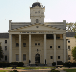
Limestone College at Limestone Springs Historic District in Gaffney
|
|||
|
|||

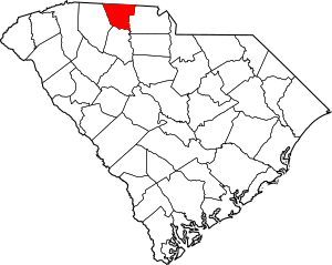
Location within the U.S. state of South Carolina
|
|||
 South Carolina's location within the U.S. |
|||
| Country | |||
| State | |||
| Founded | 1897 | ||
| Named for | Cherokee Indians | ||
| Seat | Gaffney | ||
| Largest community | Gaffney | ||
| Area | |||
| • Total | 397.47 sq mi (1,029.4 km2) | ||
| • Land | 392.96 sq mi (1,017.8 km2) | ||
| • Water | 4.51 sq mi (11.7 km2) 1.13% | ||
| Population
(2020)
|
|||
| • Total | 56,216 | ||
| • Estimate
(2023)
|
56,714 | ||
| • Density | 143.06/sq mi (55.24/km2) | ||
| Time zone | UTC−5 (Eastern) | ||
| • Summer (DST) | UTC−4 (EDT) | ||
| Congressional district | 5th | ||
Cherokee County is a place in South Carolina, USA. In 2020, about 56,216 people lived there. Its main town is Gaffney. The county was created in 1897 from parts of other counties: York, Union, and Spartanburg. It's named after the Cherokee people, who lived here long before Europeans arrived.
Cherokee County is part of a larger area that includes Gaffney. This area is connected to the bigger Greenville-Spartanburg-Anderson region.
Contents
History of Cherokee County
For thousands of years, indigenous peoples lived in this area. The historic Cherokee people were here before Europeans came.
When European traders and settlers arrived, they used old Native American paths. These paths were called the Trading Path. The Upper Road and Lower Cherokee Traders Path went through the Piedmont region. These paths helped connect different areas.
The Lower Cherokee Traders Path linked places in what is now western North Carolina, upstate South Carolina, and northeastern Georgia. In the mid-1700s, many British people moved along these paths. About 250,000 people traveled into Cherokee and nearby counties. This backcountry area was first settled by Ulster Scots people, Germans, and Anglo-Americans.
By the mid-1800s, large farms called plantations grew in the county. These farms relied on the labor of enslaved African Americans. Their work was the main support for the county's economy. This continued until the end of the American Civil War.
During the American Revolutionary War, an important battle happened here. The Battle of Cowpens was fought on January 17, 1781. It took place in northwestern Cherokee County, near the town of Cowpens, South Carolina. This battle was a big victory for the American Patriots.
Geography and Nature
Cherokee County covers about 397.47 square miles. Most of this is land (392.96 square miles). About 4.51 square miles (1.13%) is water. It is one of the smallest counties in South Carolina.
Mountains and Hills
- Draytonville Mountain
- Brown's Mountain
- Thicketty Mountain
- Whitaker Mountain
Locals often call Draytonville Mountain "McKown's Mountain." It's named after a farmer who owned a lot of land there.
Rivers and Creeks
- Broad River
- McKowns Creek
- Pacolet River
Protected Natural Areas
- Cowpens National Battlefield
- Kings Mountain National Military Park (part of it)
- London Creek Wildlife Management Area
Other Interesting Places
- Magness-Humphries House
- Peachoid
Neighboring Counties
- Cleveland County, North Carolina – to the north
- York County – to the east
- Union County – to the south
- Spartanburg County – to the west
- Rutherford County, North Carolina – to the northwest
People and Population
| Historical population | |||
|---|---|---|---|
| Census | Pop. | %± | |
| 1900 | 21,359 | — | |
| 1910 | 26,179 | 22.6% | |
| 1920 | 27,570 | 5.3% | |
| 1930 | 32,201 | 16.8% | |
| 1940 | 33,290 | 3.4% | |
| 1950 | 34,992 | 5.1% | |
| 1960 | 35,205 | 0.6% | |
| 1970 | 36,791 | 4.5% | |
| 1980 | 40,983 | 11.4% | |
| 1990 | 44,506 | 8.6% | |
| 2000 | 52,537 | 18.0% | |
| 2010 | 55,342 | 5.3% | |
| 2020 | 56,216 | 1.6% | |
| 2023 (est.) | 56,714 | 2.5% | |
| U.S. Decennial Census 1790–1960 1900–1990 1990–2000 2010 2020 |
|||
In 2020, there were 56,216 people living in Cherokee County. There were 20,699 households and 11,592 families.
Population Makeup (2020)
| Race | Num. | Perc. |
|---|---|---|
| White (not Hispanic) | 39,576 | 70.4% |
| Black or African American (not Hispanic) | 11,292 | 20.09% |
| Native American | 161 | 0.29% |
| Asian | 341 | 0.61% |
| Pacific Islander | 14 | 0.02% |
| Other/Mixed | 2,055 | 3.66% |
| Hispanic or Latino | 2,777 | 4.94% |
In 2010, the county had 55,342 people. About 75% were white, and 20.4% were Black or African American. About 3.7% of the people were of Hispanic or Latino origin. The average age was 38.3 years old.
Economy and Fun Things to Do
Cherokee County is special because it has three national parks. These are the Overmountain Victory National Historic Trail, Kings Mountain National Military Park, and Cowpens National Battlefield. You can also find many historic homes here. Some of these homes are open for tours at certain times of the year.
For people who like theater, there's the Gaffney Little Theatre. Limestone College also offers plays and musicals.
If you enjoy racing, visit the Cherokee Speedway outside Gaffney. It's a dirt track where stock car races have been held since the 1950s. Famous drivers like Bobby Isaac and Curtis Turner have raced there.
For shopping, there's Prime Outlets-Gaffney. It has over 80 stores and gets almost 3 million visitors each year. Floyd Baker Boulevard in Gaffney is another big shopping area with many stores and restaurants. Uptown Gaffney has smaller, unique shops and cafes.
The Cherokee County History and Arts Museum is a new attraction. It's located in the old Central School building. Here, you can learn about the county's history and its role in the arts and culture of the Southeast.
In 2022, the county's economy (GDP) was about $2.1 billion. Some of the largest employers in the county include Dollar Tree, Limestone University, Nestlé, Timken Company, and Walmart.
Nuclear Power Plant Project
In 2006, Duke Power chose a site in Cherokee County for a new nuclear power plant. It was planned to be called the William States Lee III Nuclear Generating Station. This site is next to an older, unfinished nuclear plant. That old site was even used as a movie set for the 1989 film The Abyss.
Duke Power planned to build two large reactors. Each could make about 1,117 megawatts of power. However, the project faced delays and rising costs. In 2017, Duke Energy announced that construction plans were put on hold. They can still decide to restart construction in the future.
Getting Around (Transportation)
I-85 is a very important highway in Cherokee County. It runs through Gaffney. This highway helps with traffic and trade, leading to many businesses along Floyd Baker Boulevard. A lot of the county's growth happens near I-85.
Cherokee County does not have its own airport. People usually use Charlotte Douglas International Airport or Greenville-Spartanburg International Airport. There have been studies about building an airport in the county. If an airport is built, the government might help pay for most of it.
Main Highways
 I-85
I-85 US 29
US 29 US 221


 US 221 Alt.
 SC 5
SC 5 SC 11
SC 11 SC 18
SC 18


 SC 18 Conn.
 SC 97
SC 97 SC 105


 SC 105 Conn. (near Draytonville)


 SC 105 Conn. (Saratt)
 SC 110
 SC 150
 SC 198
 SC 211
 SC 329
Healthcare Services
Gaffney has several places for healthcare:
Cherokee Medical Center
Cherokee Medical Center is a hospital in Gaffney. It has 125 beds and serves Cherokee County. It offers emergency care, medical services, surgery, and imaging. It became part of Spartanburg Regional Healthcare System in 2019.
Gibbs Cancer Center and Research Institute at Gaffney
This center provides cancer care. It opened in Gaffney in 2011. Its goal is to offer cancer services to the community.
Immediate Care Center – Gaffney
This center offers both urgent care and primary care. It's located on Floyd Baker Boulevard.
Medical Group of the Carolinas
This is a group of many medical offices. Several of these offices are in Cherokee County. They include doctors for families, heart doctors, bone doctors, and women's health.
Towns and Communities
Cities
Towns
- Blacksburg
- Smyrna (mostly in York County)
Other Communities
- Cherokee Falls
- East Gaffney
- Cashion Crossroads
- Draytonville
- Goucher
- Grassy Pond
- Kings Creek
- Macedonia
- State Line
- Thicketty
Old Towns (Ghost Towns)
Images for kids
See also
 In Spanish: Condado de Cherokee (Carolina del Sur) para niños
 | Jewel Prestage |
 | Ella Baker |
 | Fannie Lou Hamer |


