
Coles County, Illinois facts for kids
Quick facts for kids
Coles County
|
|
|---|---|

Coles County Courthouse
|
|

Location within the U.S. state of Illinois
|
|
 Illinois's location within the U.S. |
|
| Country | |
| State | |
| Founded | December 25, 1830 |
| Named for | Edward Coles |
| Seat | Charleston |
| Largest city | Charleston |
| Area | |
| • Total | 510 sq mi (1,300 km2) |
| • Land | 508 sq mi (1,320 km2) |
| • Water | 1.8 sq mi (5 km2) 0.4% |
| Population
(2020)
|
|
| • Total | 46,863 |
| • Density | 91.9/sq mi (35.5/km2) |
| Time zone | UTC−6 (Central) |
| • Summer (DST) | UTC−5 (CDT) |
| Congressional districts | 12th, 15th |
Coles County is a county in the state of Illinois, USA. In 2020, about 46,863 people lived here. The main town and county center is Charleston. This town is also home to Eastern Illinois University. Coles County is part of a larger area called the Charleston–Mattoon Micropolitan Statistical Area.
Contents
History of Coles County
Coles County was officially started on December 25, 1830. It was formed from parts of Clark and Edgar counties. The county is named after Edward Coles. He was the second governor of Illinois, serving from 1822 to 1826.
Early Settlers and Their Values
Most of the first American settlers in Coles County came from the New England states. Others were born in upstate New York. Their parents had moved there from New England after the American Revolution. These settlers were farmers moving west into new lands in the early 1800s. The completion of the Erie Canal helped more people move west. When they arrived, they found thick forests and open grasslands.
These New England settlers built farms and roads. They also set up government buildings and mail routes. They brought their "Yankee" values with them. These included strong support for ending slavery, known as abolitionism. They also cared a lot about education and quickly built schools. Many were members of the Congregationalist Church. Some had become Baptists or Methodists before moving. Because of these settlers, the county's culture was similar to New England's for many years. People in the county largely supported ending slavery before the American Civil War. They also supported the Republican Party in the 1850s and 1860s.
New Immigrants Arrive
Starting in 1849, many German immigrants came to Coles County. They were escaping problems in their home countries. These new residents also strongly supported ending slavery.
Irish Catholic immigrants also settled here. They had left their home country because of a terrible famine. Stephen Douglas, an Illinois Senator, was very popular with these Irish Catholic immigrants. During the American Civil War, many Irish Catholics in Coles County supported the Copperheads. This group wanted to make peace with the Southern states.
-
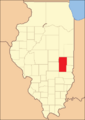
Coles County from the time of its creation to 1843
-
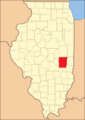
Coles County between 1843 and 1859
-
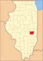
Coles County reduced to its current size in 1859 by the creation of Douglas County


Local Legends and Stories
Coles County is known for several interesting legends and folktales. These are old stories passed down through generations.
Famous Local Tales
One well-known story is about the Mad Gasser of Mattoon. Another tells of the ghost of Mary Hawkins at Pemberton Hall. A writer named Michael Kleen collected many of these tales in his book Tales of Coles County, Illinois (2010). His book includes stories like the "witch's grave" at St. Omer Cemetery. It also tells the story of "Rag Doll Cemetery."
The "Rag Doll Cemetery" legend was even made into a movie. The independent film Rag Doll was filmed in 2010, mostly in and around Mattoon, Illinois. Another book, A Family Possessed (2000) by L. W. Stevenson, is based on a family's real-life experience with strange happenings in their home during the 1980s.
Haunted Places
Ashmore Estates is another place with many local legends. It used to be a home for people who needed help. Today, many people believe it is haunted. It is a popular spot for paranormal investigators who look for ghosts.
Geography of Coles County
Coles County covers about 510 square miles. Most of this area, about 508 square miles, is land. The rest, about 1.8 square miles, is water.
Climate and Weather
| Weather chart for Charleston, Illinois | |||||||||||||||||||||||||||||||||||||||||||||||
|---|---|---|---|---|---|---|---|---|---|---|---|---|---|---|---|---|---|---|---|---|---|---|---|---|---|---|---|---|---|---|---|---|---|---|---|---|---|---|---|---|---|---|---|---|---|---|---|
| J | F | M | A | M | J | J | A | S | O | N | D | ||||||||||||||||||||||||||||||||||||
|
2.2
35
19
|
2.4
41
24
|
3.4
53
33
|
4
65
43
|
4.2
75
52
|
3.9
85
61
|
4.7
88
65
|
3.5
86
63
|
3.2
79
56
|
3.3
68
45
|
3.9
53
34
|
3.2
40
24
|
||||||||||||||||||||||||||||||||||||
| temperatures in °F precipitation totals in inches source: The Weather Channel |
|||||||||||||||||||||||||||||||||||||||||||||||
|
Metric conversion
|
|||||||||||||||||||||||||||||||||||||||||||||||
The weather in Charleston, the county seat, changes throughout the year. In January, the average low temperature is about 19°F. In July, the average high temperature is about 88°F. The coldest temperature ever recorded was -27°F in January 1994. The hottest was 110°F in July 1936. The county gets between 2.20 and 4.65 inches of rain or snow each month. July usually has the most precipitation.
Neighboring Counties
Coles County shares borders with these other counties:
- Douglas County (north)
- Edgar County (northeast)
- Clark County (southeast)
- Cumberland County (south)
- Shelby County (southwest)
- Moultrie County (west)
Main Roads
Several important highways pass through Coles County:
 Interstate 57
 US Route 45
 Illinois Route 16
 Illinois Route 49
 Illinois Route 121
 Illinois Route 130
 Illinois Route 133
Public Transportation
- Dial-A-Ride Rural Public Transportation
- Mattoon station
Population Information

| Historical population | |||
|---|---|---|---|
| Census | Pop. | %± | |
| 1840 | 9,616 | — | |
| 1850 | 9,335 | −2.9% | |
| 1860 | 14,203 | 52.1% | |
| 1870 | 25,235 | 77.7% | |
| 1880 | 27,042 | 7.2% | |
| 1890 | 30,093 | 11.3% | |
| 1900 | 34,146 | 13.5% | |
| 1910 | 34,517 | 1.1% | |
| 1920 | 35,108 | 1.7% | |
| 1930 | 37,315 | 6.3% | |
| 1940 | 38,470 | 3.1% | |
| 1950 | 40,328 | 4.8% | |
| 1960 | 42,860 | 6.3% | |
| 1970 | 47,815 | 11.6% | |
| 1980 | 52,260 | 9.3% | |
| 1990 | 51,644 | −1.2% | |
| 2000 | 53,196 | 3.0% | |
| 2010 | 53,873 | 1.3% | |
| 2020 | 46,863 | −13.0% | |
| 2023 (est.) | 46,060 | −14.5% | |
| U.S. Decennial Census 1790-1960 1900-1990 1990-2000 2010-2013 |
|||
In 2010, there were 53,873 people living in Coles County. The county is home to people from many different backgrounds. Most residents are white, but there are also Black or African American, Asian, and American Indian people. About 2.1% of the population is of Hispanic or Latino origin.
Many families live in Coles County. The average age of people living here was about 31.6 years old in 2010.
Towns and Villages

Coles County has several cities and villages.
Cities
- Charleston (the main county town)
- Mattoon
- Oakland
Villages
Small Communities (Unincorporated)
These are smaller places that are not officially cities or villages:
- Bushton
- Campbell
- Coles
- Cooks Mills
- Diona
- Dorans
- Embarrass
- Etna
- Fairgrange
- Fuller
- Hutton
- Janesville
- Jones
- Kings
- Lipsey
- Loxa
- Magnet
- Newby
- Paradise
- Rardin
- Trilla
- Wabash Point
Townships
Coles County is divided into twelve smaller areas called townships:
- Ashmore
- Charleston
- East Oakland
- Humboldt
- Hutton
- Lafayette
- Mattoon
- Morgan
- North Okaw
- Paradise
- Pleasant Grove
- Seven Hickory
Schools and Colleges
Coles County has several places for learning:
- Eastern Illinois University
- Lake Land College
- Lakeview College of Nursing (in Charleston)
- Charleston Community Unit School District 1
- Mattoon Community Unit School District 2
- Oakland Community Unit School District 5
Famous People from Coles County
.png)
- Thomas Lincoln, who was the father of President Abraham Lincoln, moved to Coles County in 1831. He lived there until he passed away in 1851.
See also
 In Spanish: Condado de Coles para niños
