
Comanche Springs (Texas) facts for kids
Quick facts for kids Comanche Springs |
|
|---|---|
.jpg) |
|
| Name origin | Awache (Wide Water) |
| Location | Pecos County, Texas |
| Coordinates | 30°52′54″N 102°52′44″W / 30.88167°N 102.87889°W |
| Spring source | Edwards Aquifer |
| Elevation | 2,940 feet (896.1 m) |
| Type | Artesian aquifer |
| Provides water for | Rio Grande |

Location in Texas

Location in the United States
|
|
Comanche Springs was a special place in West Texas. It had six natural springs that bubbled up from underground. These springs were located between the Edwards Plateau and the Trans-Pecos areas. The water came from a huge underground water source called the Edwards Aquifer. This aquifer is like a giant sponge of rock that holds water.
The water from Comanche Springs flowed north into Comanche Creek. This creek then joined with Leon Creek and later the Pecos River. The Pecos River is a smaller river that eventually flows into the much larger Rio Grande.
Contents
History of Comanche Springs
Ancient Times and Spanish Explorers
Comanche Springs was like a desert oasis (a wet, fertile spot in a dry area). People have lived near these springs since ancient times, long before Christopher Columbus arrived. The Jumano Indians were some of the first people to live there.
In 1536, a Spanish explorer named Álvar Núñez Cabeza de Vaca explored the Rio Grande area. Later, in 1675, Fernando del Bosque explored the region for Spanish missions. Another explorer, Juan Domínguez de Mendoza, also stayed near the springs in the late 1600s.
Forts and the Wild West
On March 23, 1859, a military camp called Camp Stockton was built near the springs. This fort was a base for the United States Cavalry (soldiers on horseback). Their job was to protect settlers and travelers from Plains Indians.
Many important routes passed through this area. These included the Butterfield Overland Mail route, where stagecoaches carried mail and people. Other trails like the Old San Antonio Road and Old Spanish Trail were also used by covered wagons and wagon trains. The fort helped keep these paths safe.
Native American Life

Native American tribes like the Apache, Comanche, and Kiowa often visited Comanche Springs. It was an important stop during their bison hunts. They also used the springs during conflicts like the Comanche–Mexico Wars.
These tribes were nomadic, meaning they moved from place to place. The Comanche Trail was a path they used for their travels. It helped them move through the West Texas desert, especially during the cold northern hemisphere winter. The trail connected many springs, including those in Texas Big Bend Country and places like Big Spring.
Water for Farms
Starting in 1875, people began using the water from Comanche Springs for farming. They created an irrigation district to bring water to their crops. This was in the Chihuahuan Desert, which is a very dry area.
A farming area called Belding, about 11 miles (18 km) southwest of the springs, grew very quickly. It needed a lot of water. Farmers used so much water to irrigate 6,000 to 7,000 acres (2,400 to 2,800 hectares) of land. This overuse of water, called overdrafting, caused the natural springs to dry up. The underground water level, or water table, dropped significantly.
Historical Marker
Comanche Springs was recognized as an important historical site in 1968. A special marker was placed there to remember its history.
Illustrations
- Texas Historical Markers at Comanche Springs
-
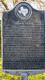
Comanche Springs historical marker established by Texas Historical Commission
-
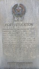
Fort Stockton historical marker established by Texas Historical Commission


