
Commonwealth Heritage List in Queensland facts for kids
The Commonwealth Heritage List in Queensland is a special list of important places in Queensland, Australia. These places are chosen because they have a lot of history, cultural meaning, or natural beauty. They are usually on land or in waters owned or managed by the Australian Government. To get on this list, a place must meet one or more of nine special rules. Think of it like a "hall of fame" for places that are super important to Australia's story!
Places Currently on the List
As of April 30, 2020, there are 31 amazing places in Queensland that are on the Commonwealth Heritage List. These places are protected so everyone can enjoy them for many years to come.
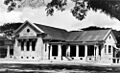
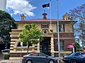
Many of these places are old post offices. These buildings are important because they show how people used to communicate and how towns grew. Some examples include:
- The Ayr Post Office in Ayr, Queensland.
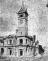
- The Boonah Post Office in Boonah, Queensland.
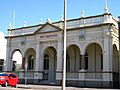
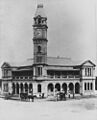
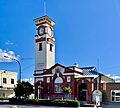
- The Bundaberg Post Office in Bundaberg.
- The Charters Towers Post Office in Charters Towers.
- The Cooroy Post Office in Cooroy, Queensland.
- The Ingham Post Office in Ingham, Queensland.
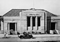
- The Maryborough Post Office in Maryborough, Queensland.
- The Stanthorpe Post Office in Stanthorpe, Queensland.
- The Warwick Post Office in Warwick, Queensland.
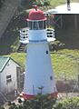
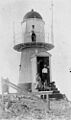
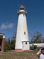
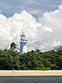
Other important historic places include lighthouses that guided ships safely along the coast. These tall structures have helped sailors for many years. Some of these lighthouses are:
- The Dent Island Light near Whitsundays, Queensland.
- The Goods Island Light in the Torres Strait.
- The Lady Elliot Island Light in the Coral Sea.
- The Low Isles Light in Low Isles, Queensland.
- The North Reef Light off Rockhampton.
Military sites are also very important for understanding Australia's past. These places often have old buildings or training areas. Some examples are:
- The Enoggera Magazine Complex at Gallipoli Barracks in Enoggera, Queensland.
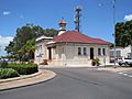
- The Green Hill Fort on Thursday Island, which was built to protect the area.
- The Macrossan Stores Depot Group on the Flinders Highway.
- The RAAF Base Amberley heritage structures in Amberley, Queensland.
- The Remount Complex in Enoggera, Queensland.
- The School of Musketry at Gallipoli Barracks in Enoggera, Queensland.
- The Small Arms Magazine at Gallipoli Barracks in Enoggera, Queensland.
- Victoria Barracks in Petrie Terrace, Queensland.
Some places are listed for their natural beauty and importance, often linked to military training areas that have protected natural environments. These include:
- The Greenbank Military Range in Greenbank, Queensland.
- The Land Warfare Centre in Canungra, Queensland.
- The Shoalwater Bay Military Training Area in Byfield, Queensland.
- The Tully Training Area in Tully, Queensland.
- The Wide Bay Military Reserve in Tin Can Bay, Queensland.
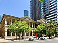
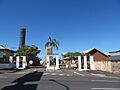
The General Post Office, Brisbane and the Naval Offices in Brisbane City are also on the list. These buildings are very important parts of Queensland's history in its capital city.
Places Formerly on the List
As of April 30, 2020, only one place in Queensland has been removed from the Commonwealth Heritage List. This was the Kissing Point Fortification in North Ward, Queensland. Even though it's no longer on this specific list, it's still a historically important site.
Images for kids
-
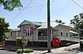
ABC Radio Studios in Rockhampton
-
Ayr Post Office
-
Boonah Post Office
-
Bowen Post Office
-
Bundaberg Post Office
-
Charters Towers Post Office
-
Cooroy Post Office
-
Dent Island Light
-
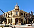
General Post Office, Brisbane
-
Goods Island Light
-
Ingham Post Office
-
Lady Elliot Island Light
-
Low Isles Light
-
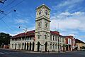
Maryborough Post Office
-
Naval Offices, Brisbane
-
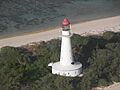
North Reef Light
-
Stanthorpe Post Office
-
Victoria Barracks, Brisbane
-
Warwick Post Office
-
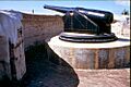
Gun at Kissing Point Fortification


