
Continent facts for kids
A continent is a really big piece of land on Earth. Think of them as the largest land areas we have! There isn't one strict rule for what makes a continent, so people usually agree on how many there are. Most people say there are seven continents.
These seven continents, from the biggest to the smallest, are: Asia, Africa, North America, South America, Antarctica, Europe, and Australia.

Even though continents are huge landmasses, some parts of the Earth's land are actually under the ocean. These are called submerged continents. One example is Zealandia, which is mostly underwater, but parts of it stick out, like New Zealand.
Islands are often grouped with a nearby continent. This helps divide all the world's land into different regions. For example, many islands in the Pacific Ocean are grouped with the continent of Australia. Together, they form a region called Oceania.
Contents
What Makes a Continent?

People usually think of continents as large, connected pieces of land. They are ideally separated by big areas of water. But some of the seven continents we know aren't fully separated by water.
For example, the idea of "large" can be a bit tricky. Greenland is the world's largest island. It's about 2,166,086 square kilometers. But Australia, which is about 7,617,930 square kilometers, is called the smallest continent. So, size isn't the only thing that decides if something is a continent.
All of Earth's main landmasses touch one big, connected World Ocean. This ocean is then divided into smaller parts by the continents and other natural features.
Different Ways to See Continents
Not everyone uses the same list of continents! Here are some common ways people divide the world:
- Seven-Continent Model: This is the most common model. It's taught in places like China, India, the Philippines, and many English-speaking countries like Australia and the United Kingdom. This model lists Asia, Africa, North America, South America, Antarctica, Europe, and Australia.
- Six-Continent (Combined Eurasia) Model: In this model, Europe and Asia are seen as one big continent called Eurasia. This is often used in Russia, Eastern Europe, and Japan.
- Six-Continent (Combined America) Model: Here, North America and South America are considered one continent called America. This model is common in France, Italy, Spain, Latin America, and Greece.
- Five-Continent Model: This model starts with the six-continent combined-America model. Then, it leaves out Antarctica because very few people live there permanently. You might see this model used by the United Nations or in the Olympic Charter.
The term Oceania refers to many island countries and territories in the Pacific Ocean. These are grouped with the continent of Australia. Sometimes, this term is used instead of just "Australia" when talking about continents.
Continents on the Move
Continents are not stuck in one place! They actually move very slowly over time. This movement is due to tectonic plates under the Earth's surface. Sometimes, continents even push against each other.
For example, the Indian subcontinent has been slowly crashing into the Eurasian continent for millions of years. As these huge landmasses push together, they buckle and bend. This is why the Himalaya Mountains, where Mount Everest is, are still growing taller today!
Other Ways to Divide Land
Supercontinents
Long, long ago, all the continents were joined together in even bigger landmasses called Supercontinents. Imagine a giant puzzle where all the pieces fit together! Some famous supercontinents from Earth's past include Pangaea, Gondwana, and Rodinia.
Subcontinents
Some very large parts of continents are called Subcontinents. These are often big peninsulas that are somewhat separated from the main continent by mountains or other features. The most well-known examples are the Indian subcontinent and the Arabian Peninsula.
Sometimes, these "subcontinents" are on different tectonic plates than the rest of the continent. This gives a geological reason for calling them subcontinents.
If you think of North and South America as one big continent (America), then North America and South America are considered subcontinents. If Eurasia is seen as one continent, then Europe is treated as a subcontinent.
Submerged Continents
As mentioned before, some areas of land that are part of a continent are mostly covered by the sea. These are called submerged continents. The most famous one is Zealandia, which is mostly underwater but includes New Zealand and New Caledonia above the surface.
Microcontinents
Some islands are actually small pieces of continental land that have broken off and drifted away from a main continent. These are called microcontinents. Madagascar, a very large island off the coast of Africa, is sometimes called a "microcontinent."
Botanical Continents

Scientists who study plants sometimes divide the world into "botanical continents." These divisions help them record where different plants grow. Some of these "botanical continents" are similar to the usual geographical continents, but others are quite different. For example, the Americas are split into "Northern America" and "Southern America" for plant studies, which is different from the usual North and South America.
The Word Continent
The word "continent" comes from an old English term, "continent land." This meant "continuous" or "connected land." It was used to describe any connected piece of land, not just the huge ones we think of today. For example, in the past, people might have called the mainlands of Ireland or Wales "continents."
Images for kids
-
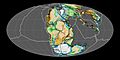
Reconstruction of the supercontinent Pangaea about 200 million years ago.
-
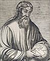
The Ancient Greek geographer Strabo holding a globe showing Europa and Asia
-
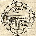
A medieval map showing the three continents as areas for Noah's sons—Asia for Sem (Shem), Europe for Iafeth (Japheth), and Africa for Cham (Ham).
-
Universalis Cosmographia, Waldseemüller's 1507 world map—the first to show the Americas as separate from Asia.
-
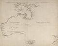
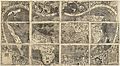
Hollandia Nova, a 1659 map based on voyages by Abel Tasman and Willem Jansz. This image shows a French version from 1663.


See also
 In Spanish: Continente para niños
