
Course of the Rogue River (Oregon) facts for kids
Quick facts for kids Rogue River |
|
|---|---|

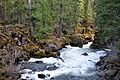
Below Natural Bridge along the upper Rogue River
|
|

Mouth of the Rogue River in Oregon
|
|
| Country | United States |
| State | Oregon |
| County | Klamath, Douglas, Jackson, Josephine, and Curry |
| City | Grants Pass |
| Physical characteristics | |
| Main source | Boundary Springs in Crater Lake National Park Cascade Range, Klamath County, Oregon 5,320 ft (1,620 m) 43°3′57″N 122°13′56″W / 43.06583°N 122.23222°W |
| River mouth | Pacific Ocean Gold Beach, Curry County, Oregon 0 ft (0 m) 42°25′21″N 124°25′45″W / 42.42250°N 124.42917°W |
| Length | 215 mi (346 km) |
| Basin features | |
| Basin size | 5,175 sq mi (13,400 km2) |
The Rogue River is a famous river in Oregon, a state in the United States. It starts at Boundary Springs, near Crater Lake National Park. The river flows generally west for about 215 miles (346 km) (that's like driving from one end of Oregon to the other!). It travels through beautiful forests and mountains, finally reaching the Pacific Ocean at Gold Beach.
Many towns are located along the Rogue River, including Grants Pass and Gold Beach. Important smaller rivers, called tributaries, flow into the Rogue. These include the Applegate River and the Illinois River. The river begins high up, at 5,320 feet (1,622 m) above sea level, and drops all the way down to the ocean.
A big part of the Rogue River, about 124 miles (200 km), is special. It's called a National Wild and Scenic River. This means it's protected for its natural beauty and outdoor activities. The Rogue is one of only three rivers in Oregon that start in the Cascade Mountains and flow all the way to the Pacific Ocean!
Contents
Journey of the Rogue River
The Rogue River's journey can be split into different sections, each with its own unique features.
From Boundary Springs to Lost Creek Lake
The river begins as a small stream in Klamath County and quickly enters Douglas County. It flows north for a short distance before turning west. Along this early part, you can find the Upper Rogue River Trail, a path for hikers. The river also passes over several waterfalls, making for scenic views.

As the river continues, it enters Jackson County. Here, it flows into the amazing Rogue River Gorge. This is a deep, narrow canyon where the water rushes through. Near the gorge, you'll find the community of Union Creek and the Natural Bridge, a cool rock formation. The river then flows through Takelma Gorge. Further downstream, near the town of Prospect, the river's water is used for hydroelectricity projects, which create power. The river drops quite a bit in elevation in this section, about 62 feet per mile (12 m/km) for every mile!
Just past Prospect, the Rogue River flows into Lost Creek Lake. This is a large reservoir created by a dam. While in the lake, the river collects water from several smaller creeks before reaching the dam's spillway.
From Lost Creek Lake to the Applegate River
After leaving Lost Creek Lake, the Rogue River continues its journey west. It passes by Casey State Recreation Site and collects water from larger creeks like Big Butte Creek and Elk Creek. The river then flows through the city of Shady Cove.
Further downstream, the river passes by the Denman Wildlife Area and TouVelle State Recreation Site. You might notice several gravel pits along the river here. The Rogue then flows past the site of the former Gold Ray Dam, which was removed in 2010. This area is important for fish.

The river then reaches the city of Gold Hill and flows between it and Interstate 5. It picks up more water from creeks like Galls Creek and Sardine Creek. The Rogue then passes by Valley of the Rogue State Park and the city of Rogue River. Finally, it reaches the site of the former Savage Rapids Dam and enters Josephine County.
The river then flows into Grants Pass, a larger city. Here, it passes under several bridges. After Grants Pass, the Applegate River joins the Rogue, adding a lot more water. In this section, the river flows much more gently, dropping only about 10 feet per mile (1.9 m/km).
From the Applegate River to Agness

This section of the Rogue River is part of its protected Wild and Scenic area, stretching for about 84 miles (135 km). It's known for its beautiful scenery and exciting rapids. The river flows past parks like Whitehorse Park and Indian Mary Park.
As it continues, the Rogue enters Hellgate Canyon, a famous and challenging part of the river for rafters. It then flows through Taylor Gorge. Many smaller creeks join the river in this wild section, including Grave Creek. The Lower Rogue River Trail follows the river here, offering great views.
The river turns sharply west and passes Grave Creek Falls and Rainie Falls, which are exciting spots. It also flows through several rapids with fun names like Wildcat Rapids and Russian Rapids. This part of the river is very popular for whitewater rafting. The river then leaves Josephine County and enters Curry County.
The river continues through Mule Creek Canyon and the Narrows, which are very narrow and dramatic sections. It passes by Inspiration Point and flows through Blossom Bar Rapids. Finally, the Rogue River reaches the community of Agness, where the Illinois River flows into it. The river's slope in this section is steeper, averaging 18 feet per mile (3.4 m/km).
From Agness to Gold Beach

Below Agness, the Rogue River flows through Copper Canyon and Bear Canyon. It continues to collect water from many smaller creeks. The river then reaches Lobster Bar, where it leaves the protected Wild and Scenic area and the Rogue River – Siskiyou National Forest.
The river widens as it gets closer to the ocean, flowing past several sand bars. Finally, the Rogue River passes under U.S. Route 101 between Wedderburn and Gold Beach. Here, it flows into the vast Pacific Ocean, completing its long journey. In this final stretch, the river's slope is much gentler, averaging only 3.7 feet per mile (0.7 m/km).
River Flow (Discharge)
The "discharge" of a river is how much water flows through it at a certain point. Scientists use special tools called stream gauges to measure this. The Rogue River has several of these gauges along its path.
- Near Prospect, the river's average flow between 1969 and 2007 was about 1,453 cubic feet per second (41 m3/s). The highest flow recorded here was 12,200 cubic feet per second (345 m3/s) in 1997, and the lowest was 166 cubic feet per second (5 m3/s) in 1992.
- Near Eagle Point, the average flow was around 2,389 cubic feet per second (68 m3/s) between 1978 and 2007. The biggest flow here was 87,600 cubic feet per second (2,481 m3/s) during a huge flood in 1964!
- At Grants Pass, the average flow was about 3,246 cubic feet per second (92 m3/s) from 1978 to 2007. The record high flow here was 152,000 cubic feet per second (4,300 m3/s) in 1964.
- Near Agness, closer to the mouth, the average flow is much higher, about 6,622 cubic feet per second (188 m3/s). This is because many other rivers have joined the Rogue by this point. The highest flow ever recorded here was an amazing 290,000 cubic feet per second (8,200 m3/s) in December 1964! This shows how powerful the river can be during floods.
Images for kids
-

Panorama of the Rogue River near Indian Mary Park
-
Below Natural Bridge on the upper river
-
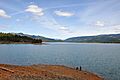
View of Lost Creek Lake, looking east from the top of the William L. Jess Dam
-
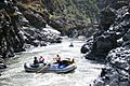
Rafting Mule Canyon on the lower Rogue


