
Upper and Lower Table Rock facts for kids
Quick facts for kids Upper and Lower Table Rock |
|
|---|---|

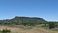
Terrain of the Table Rocks. Upper Table Rock is on the right, Lower Table Rock is on the left.
|
|
| Highest point | |
| Peak | Upper Table Rock |
| Elevation | 2,091 ft (637 m) |
| Geography | |

Location in Oregon
|
|
| Country | United States |
| State | Oregon |
| County | Jackson County |
| Nearest city | White City, OR |
| Range coordinates | 42°27′54″N 122°56′6″W / 42.46500°N 122.93500°W |
| Topo map | USGS Sams Valley |
| Geology | |
| Age of rock | 7 million years |
| Mountain type | volcanic plateaus |
Upper Table Rock and Lower Table Rock are two large, flat-topped mountains in Jackson County, Oregon, U.S. They are located just north of the Rogue River. These unique landforms were created about seven million years ago by a lava flow. Over time, erosion shaped them into what they are today. They now stand about 800 feet (240 meters) above the surrounding Rogue Valley.
The Table Rocks are special places. They are owned and protected by two groups: The Nature Conservancy and the Bureau of Land Management. These groups work together to keep the area safe for its many plants and animals.
Long before European settlers arrived, Native Americans lived in the Table Rocks area for at least 15,000 years. In the mid-1800s, during a gold rush, settlers moved into the area. This led to the Takelma tribe, who lived there, being moved to reservations.
The Table Rocks were not officially protected until the 1970s. Today, they are home to over 70 types of animals and 340 types of plants. This includes more than 200 kinds of wildflowers. Special vernal pools on top of the rocks fill with water in winter and spring. These pools are vital for unique species like the dwarf woolly meadowfoam wildflower and a rare type of fairy shrimp. Because of these important species, the Bureau of Land Management has called the rocks an Area of Critical Environmental Concern since 1984.
The Table Rocks are also a very popular spot for hiking. More than 45,000 people visit them every year. There are two main trails, one for Upper Table Rock and one for Lower Table Rock. These trails were built in the early 1980s by young people and volunteers.
The rocks get their name from their flat tops, which look like tables. "Upper" and "Lower" refer to their position along the Rogue River, not their height. Upper Table Rock is upstream and slightly taller at 2,091 feet (637 meters). Lower Table Rock is downstream and is 2,049 feet (625 meters) tall.
Contents
How the Table Rocks Were Formed
The Table Rocks have an interesting geological story. About 40 million years ago, a large river called the "Ancestral Rogue River" flowed through this area. This river deposited layers of sand and silt.
Then, about seven million years ago, a long lava flow from a volcano near Lost Creek Lake moved down the ancient river valley. This lava was very hard and covered the softer ground below. This hard lava cap is what makes the Table Rocks so unique.
Over millions of years, the Rogue River continued to erode the land. It washed away 90 percent of the solidified lava. However, the hard lava cap on top of the Table Rocks protected them from being eroded. The softer rock around the edges of the plateaus washed away. This created steep slopes around the flat tops. Both Upper and Lower Table Rock now stand about 800 feet (240 meters) above the valley floor.
The Table Rocks are an example of "inverted relief." This means that areas that used to be low (like river valleys) became high points after the surrounding land eroded away. Each plateau is shaped like a horseshoe. This is because the lava followed the bends of the Ancestral Rogue River.
Caves and Old Mines
At the base of Upper Table Rock, there are two natural caves and two old gold mines. The caves were formed by cracks in the rock. The gold mines were dug by people looking for gold in the 1800s. Three of these spots are big enough to walk into. One is a small pit that drops 30 feet (9 meters) into a pond.
A Look at Human History
People have lived near the Table Rocks for at least 15,000 years. The Takelma people called this region home. They gathered food like acorns and seeds. They also caught salmon from the Rogue River. The Takelma had several names for the rocks, including Di'tani ("rock above"). The names Upper Table Rock and Lower Table Rock were first recorded in 1845 by a mountain man named James Clyman.
Early Settlers and Conflicts
In the early 1850s, the gold rush brought many new settlers to the area. This led to conflicts with the Rogue River Indians. In 1853, a peace treaty was signed. The Native Americans gave up a large area of land. In return, they received money and supplies.
The Takelma people were then moved to the Table Rock Indian Reservation. This reservation was located between Upper Table Rock and Evans Creek. After three years, the people were moved again to other reservations farther north.
Development and Protection
After the Native Americans were moved, the area around the Table Rocks began to develop. A post office was set up in 1872. In 1948, a local rancher built a small airstrip on Lower Table Rock. He hoped to attract celebrities from Hollywood. This airstrip was closed in the late 1980s.
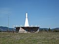
Since the 1960s, the Federal Aviation Administration has operated a tall aviation tower on Upper Table Rock. This tower helps airplanes navigate by broadcasting signals.
In 1978, The Nature Conservancy became worried about too much building in the area. They raised money to buy land on Lower Table Rock. This created the Lower Table Rock Preserve. They started projects to protect the land, like controlled burning and removing harmful plants.
In 1981, the Upper Table Rock Trail was built. A year later, the Lower Table Rock Trail was also created. In 1984, the Table Rocks were named an Area of Critical Environmental Concern. In 2009, The Nature Conservancy bought even more land. This ended private ownership of the rocks and helped protect them even more.
Plants and Animals of the Table Rocks
The Table Rocks are home to many different kinds of plants and animals. Scientists have found four main natural areas, or "ecological regions," on the rocks. Each region has its own unique wildlife.
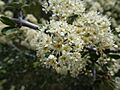
Over 340 types of plants grow here, including about 200 kinds of wildflowers. Some common wildflowers are western buttercups and desert parsley. You can also find camas, which has an edible bulb, and death camas, which is poisonous.
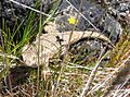
More than 70 types of animals live on the Table Rocks. Lizards like the western fence lizard and different kinds of garter snakes are found in all regions. Larger animals like black-tailed deer, coyotes, and bobcats also live here. Many types of birds make their home on the rocks too.
The Table Rocks have a Mediterranean climate. This means they have warm, dry summers and mild, wet winters. It rarely snows here.
Oak Savanna: Grasslands and Oaks
The oak savanna is found on the lowest slopes of the Table Rocks. It's like a grassland with scattered Oregon white oak trees. The Takelma tribe used to set small fires here. This helped keep the brush from growing too thick. It also created good areas for animals like deer to find food.
Many birds live in the oak savanna, including the oak titmouse and western bluebird. Snakes like the ringneck snake and Pacific gopher snake are also found here.
Chaparral: Tough Shrubs
Chaparral is a type of shrubland that gets very little rain. Plants here have adapted to dry conditions. Common plants include manzanita and buckbrush. These plants often need fire to help them reproduce. The rare Gentner's fritillary flower also grows in this region.
American black bears have been seen in the chaparral, especially in the fall. Birds like titmice and Anna's hummingbirds are also common.
Mixed Woodland: Shady Forests
The mixed woodland is a dense forest located near the tops of the plateaus. The trees here create a lot of shade, making the ground cooler. This also helps keep water from evaporating. You'll find trees like California black oak, Douglas fir, and incense cedar.
Rodents like the California ground squirrel and western gray squirrel live in this region. Many types of birds, including western tanagers and different kinds of warblers, can be found here.
Mounded Prairie and Vernal Pools: Unique Habitats
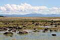
The mounded prairie is on top of the plateaus. It has many grasses and wildflowers around special vernal pools. These pools are created by water that collects in mounds of soil. The dwarf woolly meadowfoam wildflower, which only grows on the Table Rocks, blooms near these pools in April.
When the pools fill with water in winter and spring, they become home to the vernal pool fairy shrimp. This is a threatened species. Two types of amphibians, the Pacific tree frog and the rarer western toad, also live around these pools. Mammals like California voles and raccoons can be found in this region. Birds like the western meadowlark and Turkey vultures are also common.
Hiking Trails and Views
The Table Rocks are a very popular place for hiking. Over 45,000 people visit each year. Many people also join guided hikes through the Table Rock Environmental Education Program.
Lower Table Rock Trail
The Lower Table Rock Trail climbs about 780 feet (240 meters) over 1.75 miles (2.82 kilometers). Along the trail, there are eight signs that explain the history, plants, and animals of the area.
Upper Table Rock Trail
The Upper Table Rock Trail is 1.25 miles (2.01 kilometers) long and goes up about 720 feet (220 meters).
The trails are most popular from March to May when the wildflowers are blooming. Another busy time is from September to October. On clear days, hikers can see landmarks like Mount McLoughlin and Mount Ashland from the top of the rocks.
The trails were built in the early 1980s by young people and volunteers. In 1999, a section of the Lower Table Rock trail was rerouted to make it better for the growing number of visitors. In 2005, a project made part of the Lower Table Rock trail accessible for people with disabilities, children, or the elderly.
While the views are amazing, there are some dangers. The edges of the flat tops can be crumbly. It's important to stay on the trails and be careful near the edges.
Images for kids
-
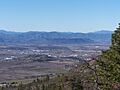
Lower Table Rock across the Rogue Valley from Roxy Ann Peak
-
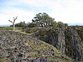
Andesite lava cap
-
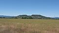
Upper Table Rock from the Denman Wildlife Area
-
The airstrip on Lower Table Rock
-
Lower Table Rock from Kirtland Road to the south
-
VORTAC located on Upper Table Rock
-
Western fence lizard on Lower Table Rock. A western buttercup flower is blooming above it.
-
Buckbrush in bloom on Lower Table Rock
-
Vernal pool and mounded prairie on Lower Table Rock plateau. Mount McLoughlin can be seen in the background.
-
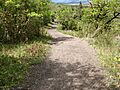
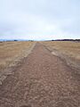
Upper Table Rock Trail
-
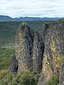
Several large andesite columns separating from Lower Table Rock
-
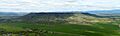
A panorama of Upper Table Rock from Lower Table Rock

.jpg)


See also
 In Spanish: Table Rock (mesetas) para niños
