
Roxy Ann Peak facts for kids
Quick facts for kids Roxy Ann Peak |
|
|---|---|

Roxy Ann Peak overlooks Medford from the east.
|
|
| Highest point | |
| Elevation | 3,576 ft (1,090 m) NAVD 88 |
| Prominence | 753 ft (230 m) NGVD 29 |
| Geography | |

Roxy Ann Peak
Location in Oregon
|
|
| Location | Jackson County, Oregon, United States |
| Parent range | Western Cascades |
| Topo map | USGS Medford East |
| Geology | |
| Age of rock | 30–35 Ma |
| Volcanic arc | Cascade Volcanic Arc |
| Climbing | |
| Easiest route | Hike |
Roxy Ann Peak, also known as Roxy Ann Butte, is a mountain that stands about 3,576 feet (1,089 meters) tall. It is located in the Western Cascades mountain range, right on the eastern edge of Medford, Oregon.
This peak is mostly made of old volcanic rock. It formed about 30 to 35 million years ago. The lower parts of the mountain are covered with oak savanna and open grassland. Higher up, you'll find a mixed coniferous forest. Even though it's not the tallest mountain, Roxy Ann Peak rises about 2,200 feet (670 meters) above Medford. This makes it easy to see from most of the Rogue Valley. It's a very important landmark for Medford, offering great views and a place for outdoor fun.
People have lived in this area for a very long time, starting 8,000 to 10,000 years ago. The Latgawa Native American tribe lived here in the early 1850s. But then, many new settlers arrived, which led to the Rogue River Wars. After these wars, the Latgawa people had to move to reservations. The peak got its name in August 1853 from Roxy Ann Hutchinson Hughes Bowen, whose family settled nearby.
In 1883, the city of Medford was started west of the mountain. Two years later, it became an official city. The city bought a lot of land from the Lions Club and the government between 1930 and 1933. In 1937, they created the 1,740-acre (704-hectare) Prescott Park. This park protects most of the mountain's upper slopes and its top. It's still mostly wild and undeveloped. Some new houses are being built on the lower southern parts of the mountain.
Contents
What Roxy Ann Peak is Made Of
Roxy Ann Peak is part of the ancient Western Cascades mountains. Other nearby peaks like Pilot Rock and Grizzly Peak are also part of this old range.
Layers of Rock
Roxy Ann Peak is built from several different layers of rock.
- The oldest layer is called the Payne Cliffs Formation. It's 35 to 50 million years old and forms the base of the peak. This layer has sandstone, shale, and conglomerate rocks.
- Most of the rest of the mountain is made of volcanic rocks. These are 30 to 35 million years old and include basalt and breccia. This layer is known as the Roxy Formation. These are some of the oldest rocks in the Cascade mountains.
- At the very top, there are younger basalt rocks that are very strong. These rocks help give the peak its unique, rounded shape.
Soils and Slopes
Much of the lower parts of Roxy Ann Peak are covered by a thick layer of sticky clay. This clay can cause the soil to slowly move downhill, which can lead to landslides. Some neighborhoods are built on top of these clay deposits. The upper parts of the mountain have shallow, dark brown, gravelly soil.
Roxy Ann Peak stands 3,576 feet (1,089 meters) above sea level. It rises about 2,200 feet (670 meters) above the Rogue Valley around it. Its unique rounded top and height make it a clear landmark. You can see it from towns like Shady Cove, which is 15.5 miles (25 kilometers) north, and the Siskiyou Summit, 23.5 miles (38 kilometers) south.
History of Roxy Ann Peak
Early People and Names
People have lived near Roxy Ann Peak for 8,000 to 10,000 years. The first people were likely nomadic, meaning they moved around. They probably ate edible plants and hunted large animals like mastodons.
Later, the Latgawa Native American tribe lived here. They called the peak Al-wiya. They likely used the mountain to gather acorns and hunt animals like black-tailed deer and small birds. These animals are still common there today.
The first European Americans came to the area in 1827. More settlers arrived a few decades later. This led to conflicts with the Latgawa people, resulting in the Rogue River Wars in 1855 and 1856. After the wars, the Latgawa were forced to move far north to the Siletz Reservation.
Early settlers first called the peak Skinner Butte. But the mountain's current name comes from Roxy Ann Bowen, one of the first people to live there. In 1853, Roxy Ann and her husband, John McKee, claimed land on the peak. By the late 1850s, it became known as Roxy Ann Peak.
Medford's Growth
In 1883, the Oregon and California Railroad started building tracks through the Rogue Valley. They built a train depot and planned out the town of Medford around it. Medford was officially named in December 1883.
In 1884, Medford residents celebrated Independence Day by firing cannons from Roxy Ann Peak's summit. Medford grew quickly and became an official city on February 24, 1885.
In the early 1900s, the mountain's lower slopes were used for pear orchards and lignite mining. Mining stopped during World War I. Many orchards were left during the Great Depression, but some still exist today.
Prescott Park's Story

In 1929, the Lions Club bought land on the peak. They gave 200 acres (81 hectares) to Medford in 1930 for people to use for fun. In 1931, the city got another 1,500 acres (607 hectares) from the government. They got 40 more acres (16 hectares) in 1933.
The park was officially named Prescott Park in 1937. It was named after George J. Prescott, a Lions Club leader and police officer who died in 1933.
Starting in 1933, the Civilian Conservation Corps (CCC) helped improve Prescott Park. They built 18 miles (29 kilometers) of trails and a 16-foot (5-meter) wide road called Roxy Ann Road. They also made picnic areas and overlooks. The CCC stopped working in 1942 because of World War II.
For many years, the park was not well cared for. By the late 1990s, there was a lot of vandalism, trash, and wildfires. Roxy Ann Road became very rough. To fix these problems, the city repaired Roxy Ann Road in 1998. They also put two gates near the park entrance in 2000. By 2006, vandalism had gone down by 70 percent.
At 1,740 acres (704 hectares), Prescott Park is Medford's biggest park. It covers most of Roxy Ann Peak's upper slopes and summit. It's more than twice as big as all of Medford's other parks put together!
Roxy Ann Peak Today

Prescott Park and Roxy Ann Peak's upper areas are still mostly wild. They are outside Medford's main city limits. The very top of the peak has a 180-foot (55-meter) tall radio tower built in 2007. This new tower replaced three older ones. Roxy Ann Peak is one of the main places for radio and TV signals in the Rogue Valley.
More houses are being built on the southern lower parts of the mountain. Building on steep slopes with unstable soil can be expensive. A law passed in 2003 made it harder and more costly to build on these kinds of slopes.
The RoxyAnn Winery is also located on the southern foothills of the peak. It's a winery that started in 2002. On the other side of the mountain is the Dry Creek Landfill. In 2006, this landfill started making electricity from the methane gas it collects.
On September 21, 2009, a wildfire started on the western slopes of Roxy Ann Peak. It burned about 633 acres (256 hectares). The fire caused 25,000 homes to lose power and forced over 100 families to leave their homes. It cost over $1.3 million to fight, but no buildings were damaged.
Plants and Animals
Roxy Ann Peak has many different kinds of plants and animals. This is because it has a wide range of elevations. It is also located where three different natural areas meet.
Plants of Roxy Ann Peak
The lower slopes of the peak have chaparral, oak savanna, and open grassland. You can find trees like California black oak, Oregon white oak, and Pacific madrone here. There are also shrubs like birchleaf mountain mahogany and sticky whiteleaf manzanita. Common grasses include blue wildrye. Wildflowers like Southern Oregon buttercup also grow here.
At higher elevations, the plants change to a coniferous forest. This forest has trees like Douglas fir, ponderosa pine, and incense cedar. The forest floor has shrubs like common snowberry and bearbrush.
Animals of Roxy Ann Peak
Many types of birds live on the peak. On the lower slopes, you might see blue-gray gnatcatchers and California quail. Higher up, there are mountain quail and mountain chickadees. Wild turkeys and raptors like golden eagles are also common. Some birds, like ruby-crowned kinglets, visit the peak in the winter.
Mammals that live on the mountain include black-tailed deer, cougars, bobcats, skunks, and coyotes. A large group of Roosevelt elk often visits the western lower slopes. In the mid-2000s, there were over 100 elk, causing traffic problems and damaging pear orchards. But by 2009, their numbers went down to about 40 after some were moved. Other common animals include western rattlesnakes and western blacklegged ticks.
Fun Things to Do

Roxy Ann Peak and Prescott Park are very important for Medford. They offer beautiful views, protected natural areas, and places for fun activities. Many people enjoy picnicking and hiking here. You can also go mountain biking and horseback riding on the 4 miles (6 kilometers) of trails in Prescott Park. These trails range from easy to steep.
In August 2013, the city of Medford and the International Mountain Bicycling Association shared a plan to improve the park's trails. This plan would add 30 miles (48 kilometers) of new trails for different uses. It would also improve existing trails and add new signs. A new starting point for trails would be added on the mountain's western side.
A challenge course opened in Prescott Park in April 2012. This course has 15 different parts, including ropes, wires, platforms, and swings. They are from 2 to 40 feet (0.6 to 12 meters) above the ground.
You can get to the peak and park using Roxy Ann Road on the southern side. There are two gates on the road. The first gate opens and closes at certain times. The second gate, about one mile further, is closed to all cars that don't have special permission. One mile past the second gate, the road splits into a 2.7-mile (4.3-kilometer) loop around the summit. Tower Road goes from this loop up to the very top of the peak.
From the top, you can see amazing views of the Rogue Valley. You can also see Mount Ashland, Mount McLoughlin, Pilot Rock, and even the rim of Crater Lake. On a clear day, you might even see Mount Thielsen, 66 miles (106 kilometers) to the north, and Mount Shasta, 72 miles (116 kilometers) to the south.

Images for kids
-
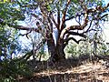
A large madrone tree in Prescott Park

