Craig County, Oklahoma facts for kids
Quick facts for kids
Craig County
|
|
|---|---|

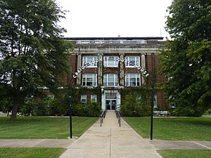
Old Craig County Courthouse in Vinita (2010)
|
|

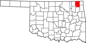
Location within the U.S. state of Oklahoma
|
|
 Oklahoma's location within the U.S. |
|
| Country | |
| State | |
| Founded | 1907 |
| Named for | Granville Craig |
| Seat | Vinita |
| Largest city | Vinita |
| Area | |
| • Total | 763 sq mi (1,980 km2) |
| • Land | 761 sq mi (1,970 km2) |
| • Water | 1.4 sq mi (4 km2) 0.2%% |
| Population
(2020)
|
|
| • Total | 14,107 |
| • Density | 18.489/sq mi (7.139/km2) |
| Time zone | UTC−6 (Central) |
| • Summer (DST) | UTC−5 (CDT) |
| Congressional district | 2nd |
Craig County is a county in the state of Oklahoma. In 2020, about 14,107 people lived here. Its main town and government center is Vinita. The county was started in 1907, just before Oklahoma became a state. It was named after Granville Craig, a well-known Cherokee farmer from the Bluejacket area.
Contents
History of Craig County
In the early 1800s, the land that is now Craig County was a hunting area for Native American tribes like the Osage nation. Later, in the 1830s, members of the Cherokee Nation moved into the area. This happened after the U.S. government forced them to leave their homes in the Southeast. This difficult journey is known as the "Trail of Tears."
The area did not have many people living in it until after the American Civil War. Important paths like the Texas Road and the East Shawnee Cattle Trail passed through the eastern part of what is now Craig County. These trails were used to move cattle from Texas.
Between 1867 and 1870, the U.S. government moved the Shawnee and Delaware tribes to this area from Kansas. This land then became part of the Cherokee Nation's territory.
In 1871, the government allowed railroad companies to build train tracks through the area. The Missouri, Kansas and Texas Railroad built a line going north and south. The Atlantic and Pacific Railroad (which later became the St. Louis and San Francisco Railway) built a line going east and west through Vinita. This helped the area grow.
People started mining for coal in Craig County after the Civil War. They used both underground tunnels and open-pit mines. Major coal production began around 1900 and continues today. Oil was also found here. The first oil refinery started working in 1911. Besides mining, farming and ranching were the main ways people made a living in the county.
Craig County was officially formed in 1907 during the Oklahoma Statehood Convention. It was named after Granville Craig, a respected Cherokee farmer who owned land near Bluejacket.
Geography and Nature
Craig County covers about 763 square miles. Most of this (761 square miles) is land, and a small part (1.4 square miles) is water. The county is located in the Osage Plains, which are flat grasslands. It is also near the western edge of the Ozark Plateau, an area with hills and forests. Water from the county flows into rivers that lead to the Neosho River.
Main Roads
Here are the major highways that run through Craig County:
 Interstate 44
 U.S. Highway 59
 U.S. Highway 60
 U.S. Highway 69
 State Highway 2
 State Highway 10
 State Highway 25
 State Highway 66
 State Highway 82
Neighboring Counties
Craig County shares borders with these other counties:
- Labette County, Kansas (north)
- Cherokee County, Kansas (northeast)
- Ottawa County (east)
- Delaware County (southeast)
- Mayes County (south)
- Rogers County (southwest)
- Nowata County (west)
People of Craig County
| Historical population | |||
|---|---|---|---|
| Census | Pop. | %± | |
| 1910 | 17,404 | — | |
| 1920 | 19,160 | 10.1% | |
| 1930 | 18,052 | −5.8% | |
| 1940 | 21,083 | 16.8% | |
| 1950 | 18,263 | −13.4% | |
| 1960 | 16,303 | −10.7% | |
| 1970 | 14,722 | −9.7% | |
| 1980 | 15,014 | 2.0% | |
| 1990 | 14,104 | −6.1% | |
| 2000 | 14,950 | 6.0% | |
| 2010 | 15,029 | 0.5% | |
| 2020 | 14,107 | −6.1% | |
| 2021 (est.) | 14,115 | −6.1% | |
| U.S. Decennial Census 1790-1960 1900-1990 1990-2000 2010 |
|||
In 2006, there were about 14,880 people living in Craig County. There were 5,620 homes and 3,945 families. The county had about 20 people per square mile.
About 68.5% of the people were White, and 16.3% were Native American. About 11.4% of people were of two or more races.
In many homes, about 31% had children under 18 living there. Most homes (57.3%) were married couples living together. The average home had about 2.46 people.
The median age in the county was 39 years old. This means half the people were younger than 39, and half were older. About 23.9% of the people were under 18 years old.
Towns and Communities
Cities
- Vinita (This is the main town and where the county government is located.)
Towns
Unincorporated Communities
These are smaller places that are not officially towns or cities.
- Centralia
- White Oak (This is a "census-designated place," meaning the government counts its population.)
Schools in Craig County
Many school districts serve the students in Craig County:
- Afton Public Schools
- Bluejacket Public Schools
- Chelsea Public Schools
- Ketchum Public Schools
- Vinita Public Schools
- Welch Public Schools
- White Oak Public Schools (This district has separate schools for younger and older students, but only runs schools for grades K-8 itself.)
There is also one elementary school district called Cleora Public School.
The Big Cabin School District used to cover parts of the county, but it closed in 1992. Its students then joined the Vinita school district.
Historic Places
Several places in Craig County are listed on the National Register of Historic Places (NRHP). This means they are important historical sites that are protected.
- Craig County Courthouse, Vinita
- First Methodist Episcopal Church, South, Vinita
- Hotel Vinita, Vinita
- McDougal Filling Station, Vinita
- Randall Tire Company, Vinita
- Spraker Service Station, Vinita
Notable People
- Shella Bowlin, a government official for the Cherokee Nation and a business leader.
See also
 In Spanish: Condado de Craig (Oklahoma) para niños


