Crawford County, Ohio facts for kids
Quick facts for kids
Crawford County
|
|||
|---|---|---|---|

|
|||
|
|||

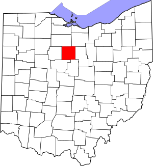
Location within the U.S. state of Ohio
|
|||
 Ohio's location within the U.S. |
|||
| Country | |||
| State | |||
| Founded | April 1, 1826 | ||
| Named for | Colonel William Crawford | ||
| Seat | Bucyrus | ||
| Largest city | Bucyrus | ||
| Area | |||
| • Total | 403 sq mi (1,040 km2) | ||
| • Land | 402 sq mi (1,040 km2) | ||
| • Water | 0.9 sq mi (2 km2) 0.2%% | ||
| Population
(2020)
|
|||
| • Total | 42,025 |
||
| • Density | 100/sq mi (40/km2) | ||
| Time zone | UTC−5 (Eastern) | ||
| • Summer (DST) | UTC−4 (EDT) | ||
| Congressional district | 5th | ||
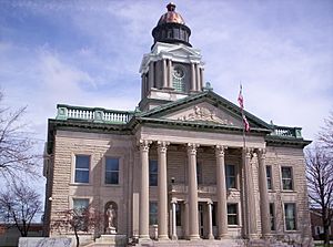
Crawford County is a county located in the middle part of Ohio. As of 2020, about 42,025 people live here. The main city and county seat is Bucyrus.
Crawford County was first created in 1820. It was officially set up in 1836. The county is named after Colonel William Crawford. He was a brave soldier during the American Revolution. The area around Bucyrus in Crawford County is sometimes called a "micropolitan area." This means it's a smaller city area that's connected to bigger cities like Mansfield and Ashland.
Contents
Where is Crawford County?
According to the U.S. Census Bureau, Crawford County covers about 403 square miles. Most of this area is land. Only a tiny part, less than one square mile, is water. It is the fourth-smallest county in Ohio by total area.
Two rivers flow through the county. These are the Sandusky River and the Olentangy River. They help drain the land.
Neighboring Counties
Crawford County shares its borders with several other counties:
- Seneca County (to the north)
- Huron County (to the northeast)
- Richland County (to the east)
- Morrow County (to the southeast)
- Marion County (to the southwest)
- Wyandot County (to the west)
How Many People Live Here?
The number of people living in Crawford County has changed over the years. Here's a quick look at the population from different census counts:
| Historical population | |||
|---|---|---|---|
| Census | Pop. | %± | |
| 1830 | 4,791 | — | |
| 1840 | 13,152 | 174.5% | |
| 1850 | 18,177 | 38.2% | |
| 1860 | 23,881 | 31.4% | |
| 1870 | 25,556 | 7.0% | |
| 1880 | 30,583 | 19.7% | |
| 1890 | 31,927 | 4.4% | |
| 1900 | 33,915 | 6.2% | |
| 1910 | 34,036 | 0.4% | |
| 1920 | 36,054 | 5.9% | |
| 1930 | 35,345 | −2.0% | |
| 1940 | 35,571 | 0.6% | |
| 1950 | 38,738 | 8.9% | |
| 1960 | 46,775 | 20.7% | |
| 1970 | 50,364 | 7.7% | |
| 1980 | 50,075 | −0.6% | |
| 1990 | 47,870 | −4.4% | |
| 2000 | 46,966 | −1.9% | |
| 2010 | 43,784 | −6.8% | |
| 2020 | 42,025 | −4.0% | |
| U.S. Decennial Census 1790-1960 1900-1990 1990-2000 2020 |
|||
In 2010, there were 43,784 people living in the county. Most people in Crawford County are white (97.2%). About 1.2% of the population was of Hispanic or Latino background. The average age of people living here was about 41.9 years old.
Towns and Communities
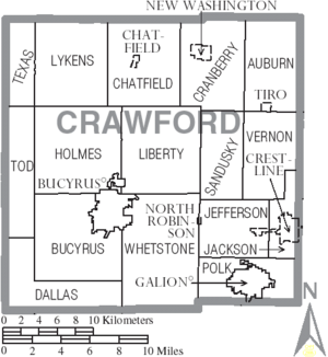
Crawford County has several cities, villages, and smaller communities.
Cities
Villages
Townships
- Auburn
- Bucyrus
- Chatfield
- Cranberry
- Dallas
- Holmes
- Jackson
- Jefferson
- Liberty
- Lykens
- Polk
- Sandusky
- Texas
- Tod
- Vernon
- Whetstone
Other Communities
Some areas are called "census-designated places." These are like small towns but not officially organized as cities or villages.
There are also many smaller, unincorporated communities:
- Benton
- Brokensword
- DeKalb
- Leesville
- Lykens
- Mechanicsburg
- Middletown
- Monnett
- New Winchester
- Olentangy
- Waynesburg
- West Liberty
Local Libraries
Crawford County has several libraries where you can find books and learn new things:
- Bucyrus Public Library in Bucyrus, Ohio
- Crestline Public Library in Crestline, Ohio
- Galion Public Library in Galion, Ohio
See also
 In Spanish: Condado de Crawford (Ohio) para niños


