Darvel facts for kids
Quick facts for kids Darvel
|
|
|---|---|
| Town | |
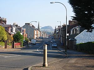 Darvel main street showing Loudoun Hill in the background |
|
| Population | 3,900 (2020) |
| OS grid reference | NS564375 |
| Council area | |
| Lieutenancy area |
|
| Country | Scotland |
| Sovereign state | United Kingdom |
| Post town | DARVEL |
| Postcode district | KA17 |
| Dialling code | 01560 |
| Police | Strathclyde |
| Fire | Strathclyde |
| Ambulance | Scottish |
| EU Parliament | Scotland |
| UK Parliament |
|
| Scottish Parliament |
|
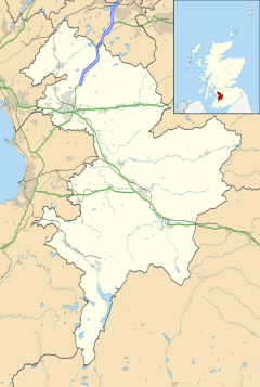
Darvel is a town in East Ayrshire, Scotland. It's located at the eastern end of the Irvine Valley. People sometimes call it "The Lang Toon," which means "the Long Town."
The town's motto is in Latin: Non sibi sed cunctis. This means "Not for ourselves, but for others."
Contents
History
Ancient Times
Experts have studied the Darvel area since 2003. They found signs that people lived here a very long time ago. This was between the Mesolithic (Middle Stone Age) and the Late Iron Age. Back then, the area was mostly covered by thick forests.
In 2007, they found an old farm from the Middle Ages. Pottery and special dating methods show it was used in the 1300s and 1400s. This farm might have been called Newton, first written about in the late 1300s.
Signs of Roman settlements have also been found. These were at the base of Loudoun Hill.
Modern Darvel
The modern town of Darvel started in the late 1700s. The name Darvel comes from old words like 'Dernvale' or 'Darnevaill'. It might mean "hidden valley."
Sir William Wallace, a famous Scottish hero, is linked to this area. A poem from the 1400s says Wallace and his men fought and beat an English army here in 1296. This was during the Wars of Scottish Independence. The poem also says an English general, Fenwick, was killed in this battle. A spot near Loudoun Hill is now called 'Wallace's Grave'.
Another important battle happened here on May 10, 1307. Robert the Bruce fought the English at Loudoun Hill.
The land where Darvel is built belonged to the Earls of Loudoun. In 1754, John Campbell, 4th Earl of Loudoun started the modern town. He wanted it to bring money to his family's estate. By 1780, over 400 people lived in Darvel.
Darvel Lace
In 1876, lace making came to the Irvine Valley. This was thanks to Alexander Morton. Soon, many mills opened in Darvel and nearby Newmilns. The lace made here was sent all over the world. India was a very big customer for lace and other fabrics.
Darvel became known as the "Lace Town." Its lace was famous worldwide. Factories also made other textiles. But by the late 1970s, the industry struggled. It couldn't compete with textiles made in other countries.
The decline was quick. By the year 2000, almost all the factories had closed. Many were empty for years, but most have now been taken down. New houses are built where they once stood. The last lace factory in Darvel has now closed. Its machines moved to Newmilns, which has the only lace factory left in the area.
Location
Darvel is on the A71 road. This road goes from Irvine on the west coast to Edinburgh on the east. The town is about 9 miles (14 km) east of Kilmarnock. It is the most eastern town in the Irvine Valley. The other towns are Galston and Newmilns.
Darvel once had railway lines. One line went to Stonehouse. Another went to Kilmarnock. Both lines are now closed. Much of the old railway path still exists, but the tracks are gone. Many bridges have also been removed.
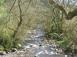
There was a very large bridge (viaduct) east of town. It carried the railway over the valley near Loudoun Hill. This bridge was taken down in 1986. Only its support pillars remain today. The River Irvine flows along the south side of the town. It used to power the local mills.
Climate
Darvel has an oceanic climate. This means it has mild temperatures and rain throughout the year. There is a weather station nearby at Saughall.
| Climate data for Saughall (221 m asl, averages 1991–2020) | |||||||||||||
|---|---|---|---|---|---|---|---|---|---|---|---|---|---|
| Month | Jan | Feb | Mar | Apr | May | Jun | Jul | Aug | Sep | Oct | Nov | Dec | Year |
| Mean daily maximum °C (°F) | 5.8 (42.4) |
6.4 (43.5) |
8.2 (46.8) |
11.1 (52.0) |
14.3 (57.7) |
16.6 (61.9) |
18.2 (64.8) |
17.9 (64.2) |
15.5 (59.9) |
11.9 (53.4) |
8.4 (47.1) |
6.1 (43.0) |
11.7 (53.1) |
| Daily mean °C (°F) | 3.1 (37.6) |
3.2 (37.8) |
4.7 (40.5) |
6.9 (44.4) |
9.6 (49.3) |
12.3 (54.1) |
14.0 (57.2) |
13.8 (56.8) |
11.6 (52.9) |
8.4 (47.1) |
5.3 (41.5) |
3.2 (37.8) |
8.0 (46.4) |
| Mean daily minimum °C (°F) | 0.4 (32.7) |
0.2 (32.4) |
1.2 (34.2) |
2.7 (36.9) |
4.9 (40.8) |
7.9 (46.2) |
9.8 (49.6) |
9.6 (49.3) |
7.8 (46.0) |
4.9 (40.8) |
2.3 (36.1) |
0.2 (32.4) |
4.4 (39.9) |
| Average rainfall mm (inches) | 148.5 (5.85) |
120.2 (4.73) |
109.1 (4.30) |
77.1 (3.04) |
78.8 (3.10) |
86.7 (3.41) |
108.4 (4.27) |
117.2 (4.61) |
113.0 (4.45) |
148.7 (5.85) |
147.4 (5.80) |
158.1 (6.22) |
1,413.1 (55.63) |
| Average rainy days (≥ 1 mm) | 18.3 | 15.8 | 14.3 | 13.1 | 12.7 | 13.2 | 14.7 | 15.6 | 14.9 | 17.3 | 17.3 | 17.9 | 185.1 |
| Mean monthly sunshine hours | 38.2 | 65.3 | 103.1 | 147.9 | 196.5 | 164.5 | 158.9 | 155.0 | 117.0 | 83.4 | 54.3 | 38.7 | 1,322.7 |
| Source: Met Office | |||||||||||||
Important Places
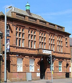
Darvel Town Hall was built around 1905. There is also the Darvel Telephone Museum, run by a retired engineer named Max Flemmich.
Monuments
- War Memorial
- The Darvel War Memorial is in Hastings Square. It is a tall, light grey stone monument. It remembers those who fought in the World Wars.
- Alexander Fleming
- A memorial at Lochfield farm honors Alexander Fleming. He was born there on August 6, 1881. He discovered penicillin, a very important medicine. Another memorial with a statue of him is in Hastings Square.
- SAS Memorial
- This memorial honors the soldiers of the 1st Special Air Service (SAS) Regiment. They were stationed in Darvel in 1944 during World War II. The memorial is a stone pile with a black granite plaque. It was unveiled in 2001.
The Dagon Stone
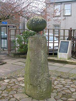
The Dagon Stone is a tall, unshaped stone. It is about 1.6 meters (5 feet) tall. Some people think it might be a very old standing stone. It has twelve small marks on its sides. Some believe these marks are linked to the sun and seasons.
In 1821, a local blacksmith put a round sandstone ball on top of it. This ball was found when people were digging a curling pond. The stone has been moved several times over the years. It is now in Hastings Square.
Long ago, newly married couples would walk around the Dagon Stone for good luck. They would walk three times in a sunwise direction. The annual town parade also used to walk around it out of respect.
The name "Dagon" might come from an old Scottish word. It could also be linked to ancient sanctuary stones.
Culture
Darvel has a Gala Day every two years. It starts with a parade through the town. The parade ends at Morton Park, where the main event takes place.
The Darvel Music Festival happens every year. It has become a popular event. It takes place in different venues around the town, including Darvel Town Hall.
Sport
Darvel has two local football teams. Darvel F.C. is a semi-professional team. They play at Recreation Park in the West of Scotland Football League. Darvel Victoria is the local amateur team. They play at the Gavin Hamilton Sports Centre.
Darvel F.C. made history on January 23, 2023. They caused one of the biggest upsets in the Scottish Cup. They beat Scottish Premiership club Aberdeen 1–0 in the fourth round.
Notable people
- Alexander Fleming, who discovered penicillin, was born at Lochfield farm.
- Christine Borland, an artist.
- John Morton Boyd, a zoologist.
- Sammy Cox, a footballer for Rangers F.C. and Scotland.
- Gordon Cree, a musician and entertainer, was born and lives in Darvel.
- Allan Gilliland, a Scottish-Canadian composer.
- Sir James Morton, who created light-fast dye.
- Craig Samson, a footballer for Kilmarnock F.C..
- Alex Smith, a footballer for Rangers F.C. and Scotland.
- Nicol Smith, a footballer for Rangers F.C. and Scotland.
- Tom Wylie, a footballer for Queen of the South F.C. and Blackburn Rovers.
- William Sheret, a showjumper.
- Ian Donald Cochrane Hopkins, a comedy writer.
See also
 In Spanish: Darvel para niños
 | John T. Biggers |
 | Thomas Blackshear |
 | Mark Bradford |
 | Beverly Buchanan |


