DeKalb County, Missouri facts for kids
Quick facts for kids
DeKalb County
|
|
|---|---|

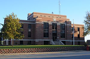
DeKalb County Courthouse in Maysville
|
|

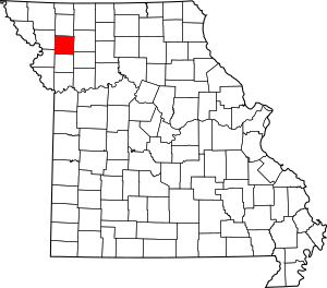
Location within the U.S. state of Missouri
|
|
 Missouri's location within the U.S. |
|
| Country | |
| State | |
| Founded | February 25, 1845 |
| Named for | Johann de Kalb |
| Seat | Maysville |
| Largest city | Cameron |
| Area | |
| • Total | 426 sq mi (1,100 km2) |
| • Land | 421 sq mi (1,090 km2) |
| • Water | 4.5 sq mi (12 km2) 1.0% |
| Population
(2020)
|
|
| • Total | 11,029 |
| • Density | 25.890/sq mi (9.996/km2) |
| Time zone | UTC−6 (Central) |
| • Summer (DST) | UTC−5 (CDT) |
| Congressional district | 6th |
DeKalb County is a county located in the northwest part of Missouri, a state in the United States. In 2020, about 11,029 people lived here. The main town and county seat is Maysville.
The county was started on February 25, 1845. It was named after General Johann de Kalb. He was a hero in the Revolutionary War. DeKalb County is also part of a larger area around St. Joseph, which is a bigger city nearby.
Contents
Geography
DeKalb County covers a total area of about 426 square miles. Most of this area, 421 square miles, is land. The rest, about 4.5 square miles, is water.
Neighboring Counties
DeKalb County shares its borders with several other counties:
- Gentry County (north)
- Daviess County (east)
- Caldwell County (southeast)
- Clinton County (south)
- Buchanan County (southwest)
- Andrew County (west)
Main Roads
Several important roads pass through DeKalb County:
 Interstate 35
 U.S. Route 36
 U.S. Route 69
 U.S. Route 169
 Route 6
 Route 31
 Route 33
Public Transport
- Jefferson Lines provides bus services.
People and Population
| Historical population | |||
|---|---|---|---|
| Census | Pop. | %± | |
| 1850 | 2,075 | — | |
| 1860 | 5,224 | 151.8% | |
| 1870 | 9,858 | 88.7% | |
| 1880 | 13,334 | 35.3% | |
| 1890 | 14,539 | 9.0% | |
| 1900 | 14,418 | −0.8% | |
| 1910 | 12,531 | −13.1% | |
| 1920 | 11,694 | −6.7% | |
| 1930 | 10,270 | −12.2% | |
| 1940 | 9,751 | −5.1% | |
| 1950 | 8,047 | −17.5% | |
| 1960 | 7,226 | −10.2% | |
| 1970 | 7,305 | 1.1% | |
| 1980 | 8,222 | 12.6% | |
| 1990 | 9,967 | 21.2% | |
| 2000 | 11,597 | 16.4% | |
| 2010 | 12,892 | 11.2% | |
| 2020 | 11,029 | −14.5% | |
| 2023 (est.) | 9,899 | −23.2% | |
| U.S. Decennial Census 1790-1960 1900-1990 1990-2000 2010-2015 |
|||
In 2000, there were about 11,597 people living in DeKalb County. The population density was about 27 people per square mile. Most people in the county were White (about 89%). About 9% were Black or African American.
About one-third of households had children under 18 living with them. The average household had about 2.5 people. The median age for people in the county was 38 years old.
Religion
DeKalb County is sometimes seen as being on the northern edge of the "Bible Belt." This is a region in the southern United States where Protestant Christianity is very common. The most common religions in DeKalb County are Southern Baptists, United Methodists, and the Community of Christ.
2020 Census Information
| Race | Num. | Perc. |
|---|---|---|
| White (NH) | 9,653 | 87.52% |
| Black or African American (NH) | 672 | 6.1% |
| Native American (NH) | 30 | 0.27% |
| Asian (NH) | 42 | 0.38% |
| Pacific Islander (NH) | 2 | 0.02% |
| Other/Mixed (NH) | 403 | 3.65% |
| Hispanic or Latino | 227 | 2.06% |
Education
DeKalb County has several public school districts. These districts serve students from kindergarten through high school.
Public Schools
- Maysville R-I School District – Maysville
- Maysville Elementary School (Grades K-6)
- Maysville Junior/Senior High School (Grades 7-12)
- Osborn R-0 School District – Osborn
- Osborn Elementary School (Grades K-6)
- Osborn Senior High School (Grades 7-12)
- Stewartsville C-2 School District – Stewartsville
- Stewartsville Elementary School (Grades K-6)
- Stewartsville Senior High School (Grades 7-12)
- Union Star R-II School District – Union Star
- Union Star Elementary School (Grades K-6)
- Union Star Senior High School (Grades 7-12)
Public Libraries
- Cameron Public Library
- DeKalb County Public Library
Communities
DeKalb County has several towns and villages where people live.
Cities
- Cameron
- Clarksdale
- Maysville (This is the county seat)
- Osborn
- Stewartsville
- Union Star
Villages
Unincorporated Communities
These are places where people live, but they don't have their own local government like cities or villages.
Former Communities
These are places that used to be towns or communities but no longer exist.
See also
 In Spanish: Condado de DeKalb (Misuri) para niños

