
Department of Piura facts for kids
Quick facts for kids
Department of Piura
|
|||
|---|---|---|---|

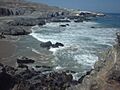
Illescas Peninsula
|
|||
|
|||
.svg)
Location of the Piura Region in Peru
|
|||
| Country | Peru | ||
| Subdivisions | 8 provinces and 64 districts | ||
| Capital | Piura | ||
| Area | |||
| • Total | 35,892.49 km2 (13,858.17 sq mi) | ||
| Elevation
(Capital)
|
29 m (95 ft) | ||
| Highest elevation | 2,709 m (8,888 ft) | ||
| Lowest elevation | -34 m (−111.5 ft) | ||
| Population
(2017)
|
|||
| • Total | 1,856,809 | ||
| • Density | 51.732521/km2 (133.98661/sq mi) | ||
| UBIGEO |
20
|
||
| Dialing code | 073 | ||
| ISO 3166 code | PE-PIU | ||
| Principal resources | Petroleum, rice, cotton, lemon | ||
| Poverty rate | 21.7% | ||
| Percentage of Peru's GDP | 3.94% | ||
| Website | www.regionpiura.gob.pe | ||


Piura (Spanish pronunciation: [ˈpjuɾa]) is a region in northwestern Peru, right by the coast. Its capital city is Piura. Important port cities like Paita and Talara are also here. The area is famous for its warm, sunny beaches.
Piura has the most people living in it compared to other regions in Peru. It is also one of the most crowded, but it is not the biggest region in size.
Contents
Geography of Piura
The Piura Region is next to the Tumbes Region and Ecuador in the north. To the east is the Cajamarca Region. The Lambayeque Region is to the south. The Pacific Ocean is to the west. "Punta Pariñas" in Piura is the westernmost point of South America.
Climate and Ocean Currents
Piura has many different climates. This is because of its location. It is only 4 degrees south of the equator. But it gets two ocean currents at the same time. The cold Humboldt Current brings cool water. The warm El Niño Current brings warmer water. This makes Piura a land that is both tropical and dry. It is called "The Land where the Tropics meets The Desert."
The coast has two main areas. The southern part is the Peruvian Sechura Desert. The central and northern parts have savanna-like scrub forests. There are also small valleys with a tropical climate. Here, you can find many rice and coconut fields. These are especially common near the Piura River and Sullana rivers.
As you go from the coast into the mountains (the sierra), you find montane forests. Higher up, the climate becomes cooler. You can find Páramo climates there.
Landforms and Rivers
The coast of Piura is mostly flat. The mountains in the Sierra are rough. There are many dry plains in the southern part. The Sechura Desert is south of the Piura River. It is Peru's largest desert. It is one of the few tropical deserts in the world. It is next to a tropical area in the north. The Bayóvar Depression is in this desert. It is the lowest point in Peru.
The coast has many dry ravines. These fill with water during heavy rains. They form tropical dry forests. Other features include half-moon shaped dunes. There are also marine terraces, like those in Máncora and Talara. Valleys have been formed by the Chira River and Piura River.
To the east, the valleys are deep. Rivers have carved them out. This has created "equatorial tropical-dry-forests." The highest peak is over 3000 meters. The Paso de Porculla is a low mountain pass. It is only 2,138 meters high. It is the lowest pass in the Peruvian Andes.
Rivers in Piura flow to two places. Some flow to the Pacific Ocean. Others flow to the Amazon Basin. The Chira River is the most important. It flows into the Pacific Ocean. The Piura River also flows to the Pacific. But its flow changes a lot with the seasons. It can even dry up during very dry periods.
Weather Patterns

The climate in Piura is mostly subtropical and tropical savanna. The southern coast near Lambayeque Region is Semi-arid. Piura has a tropical dry or tropical savanna climate. The average temperature is 26 °C (79 °F) all year. Winters (June to October) are warm and pleasant. Daytime temperatures are around 25–28 °C (77–82 °F). Nights are cooler, around 16–18 °C (61 °F).
In 2013 and 2016, Chulucanas and the Lancones District recorded very high temperatures. They reached 39.8 °C (103.6 °F). This is the highest temperature ever recorded in Peru.
Piura has many different climates. These include deserts, tropical valleys, and dry equatorial forests. There are also tropical montane climates in the mountains. Higher up, you find a humid subtropical sierra climate. The Páramo climate is in the highest parts of the Sierra.
Rain is rare from May to November. It usually rains only from December to April. This is due to the El Niño Current. But when the El Niño phenomenon is strong, there can be a lot of rain. This makes the dry ravines come alive. It also causes floods and landslides. El Niño happens when ocean waters get warmer than usual.
During the hottest summer days (December to April), temperatures can reach almost 40 °C (104 °F) inland. At night, temperatures can stay high. This makes people want to go to beach resorts like Máncora or Colán. The rest of the year has pleasant summer temperatures.
Natural Resources and Wildlife
Piura is home to unique algarrobo trees. These are similar to the carob tree. Piura has the most equatorial tropical dry forests in the Pacific region.
These forests have many kinds of orchids, birds, reptiles, and mammals. Piura is known for its old and delicious lime-lemons. It also produces some of South America's best mangoes. With Lambayeque, it is the original home of Pima cotton. Piura also grows bananas, coconuts, and rice.
The "Manglares de San Pedro de Vice" are in the Sechura Province. These are the southernmost mangroves on the Pacific coast of South America.
Piura's development has also been helped by its resources. There is petroleum in the ocean near Talara Province. Fishing is good because of the two ocean currents. Silver mines are common. There are also large Bayovar Deposits.
History of Piura

The most important ancient culture in Piura was the Vicús. They were known for their beautiful ceramics and amazing work with gold. The Tallanes or Yungas were the first people to settle here. They came from the mountains (the Sierra). For a long time, they lived in simple villages called behetrias. Later, the Mochica people conquered them. Centuries after that, the Incas took control during the rule of Tupac Inca Yupanqui.
In 1532, Francisco Pizarro founded the first Spanish city in South America. It was on the banks of the Chira River, in the Tangarará Valley. He named it San Miguel de Piura. The exact founding date is still debated. However, July 15 was chosen as the official date during the 450th anniversary celebrations.
The city had to move several times. In 1534, it moved to Monte de los Padres because of health problems. In 1578, it moved again to San Francisco de la Buena Esperanza. This was for the same reason. In 1588, constant attacks from English pirates and privateers forced the city to move one last time. It finally settled in its current location, Piura.
During colonial times, life was mostly peaceful. But raids by Admirals Borran and Cochrane, who were part of José de San Martín's fight for freedom, inspired the local people to want their own independence.
Culture and Customs of Piura

Piura has a wonderful mestizo culture. This means that many different races have mixed here. People from Piura, called Piuranos, have a unique accent. They tend to stretch out their words, similar to people in northern Mexico. Piuranos also have their own special slang. For example, they call themselves Churres. This is a popular term for a young person from Piura or the northern region.
Piuranos are known for being clever and having a welcoming personality. They also have a melancholic style of Tondero music. Like many Peruvians, they enjoy drinking chicha de jora, pisco, or beer. Many Piuranos are creative and work in art.
Local Food and Traditions
Some popular local dishes include Piuran Secho de Chavelo. This is the capital's special dish. You can also try Algarrobina cocktails. There are many types of ceviches and other seafood dishes. These include Majarisco and Pasao al Agua. Piura is also famous for its sweet natillas.
The warm climate in this region means that hard work is avoided from 1:00 p.m. to 4:00 p.m. It is a common tradition to take siestas (afternoon naps). People usually wake up early to get important things done before noon.
Religious events and processions are very important to some locals. One famous procession is Cristo de Ayabaca.
Popular crafts include Chulucana Pottery. People also make beautiful hats and silver items. These are often made in the Catacaos Province.
Northern Cowboys and Music
You can still see northern cowboys today. They travel through the deserts of Sechura and Catacaos. They also go through the forests of Morropon. They use donkeys and mules to carry their goods. They look similar to cowboys in the American Southwest, or Argentinian gauchos and Mexican charros. They are known for singing and playing Cumanana and Tondero music. They are also skilled silversmiths. They make filigree earrings, leather goods, hats, and wooden and silver tools from the Catacaos region.
The Tondero and Cumanana are the traditional music styles of the Piura Region.
Chicha music, now called Tecnocumbia, is a modern popular music style. It is a Peruvian style of cumbia with electronic sounds. Salsa music is also popular among young people.
Another important music tradition in northern Peru is the famous Peruvian Waltz. Traditional musicians in the north have their own special way of playing it.
Political Divisions
The Piura region is divided into 8 provinces. These provinces are made up of 64 districts. The provinces, with their capital cities in parentheses, are:
- Ayabaca (Ayabaca)
- Huancabamba (Huancabamba)
- Morropón (Chulucanas)
- Paita (Paita)
- Piura (Piura)
- Sechura (Sechura)
- Sullana (Sullana)
- Talara (Talara)
Main Towns and Cities
Some of the populated places in Piura include:
- Angostura
- Ayabaca
- Cabo Blanco
- Cajunga
- Catacaos
- Chato
- Chulucanas
- Huancabamba
- Máncora
- Paita
- Piura
- Punta Arenas
- Sechura
- Sullana
- Talara
- Tambogrande
Images for kids
-
Illescas Peninsula
-

Flag of Piura Region
-
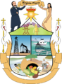
Coat of Arms of Piura Region
-
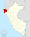
Location of the Piura Region in Peru
See also
 In Spanish: Departamento de Piura para niños
