
El Cerrito, California facts for kids
Quick facts for kids
El Cerrito, California
|
|||
|---|---|---|---|
.jpg)
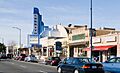
Cerrito Theater on San Pablo Avenue
|
|||
|
|||

Location of El Cerrito in Contra Costa County, California
|
|||

El Cerrito, California
Location in the United States
|
|||
| Country | United States | ||
| State | California | ||
| County | Contra Costa | ||
| Incorporated | August 23, 1917 | ||
| Area | |||
| • Total | 3.67 sq mi (9.51 km2) | ||
| • Land | 3.67 sq mi (9.51 km2) | ||
| • Water | 0.00 sq mi (0.00 km2) 0% | ||
| Elevation | 69 ft (21 m) | ||
| Population
(2020)
|
|||
| • Total | 25,962 | ||
| • Density | 7,074/sq mi (2,730.0/km2) | ||
| Time zone | UTC-8 (PST) | ||
| • Summer (DST) | UTC-7 (PDT) | ||
| ZIP code |
94530
|
||
| Area code(s) | 510, 341 | ||
| FIPS code | 06-21796 | ||
| GNIS feature IDs | 277504, 2410410 | ||


El Cerrito is a city in Contra Costa County, California, United States. Its name means "The Little Hill" in Spanish. It is part of the exciting San Francisco Bay Area.
According to the 2020 census, about 25,962 people live in El Cerrito. The city was started by people who had to leave their homes after the big 1906 San Francisco earthquake. El Cerrito became an official city in 1917 when it had about 1,500 residents.
Contents
History of El Cerrito
.jpg)
El Cerrito was founded by people who became refugees after the 1906 San Francisco earthquake. They settled on land that belonged to Don Víctor Castro. This land was next to a ranch owned by the Luís María Peralta family.
A post office opened in this settlement in 1909. The area was first called Rust, named after its first postmaster, Wilhelm F. Rust. However, the people living there didn't like the name. In 1916, they changed it to El Cerrito, which means "little hill." This name refers to Albany Hill, a nearby hill.
Just one year later, in August 1917, El Cerrito officially became a city. It started with about 1,500 residents. Several smaller communities like Stege Junction, Rust, Schmidtville, and Schindler joined to form the new city. Records from 1920 show that many Italian immigrants lived in the Schmidtville area.
Geography of El Cerrito

El Cerrito is located on the eastern side of the San Francisco Bay. It is in the very southwest part of Contra Costa County. The city's elevation changes from 20 feet to 934 feet above sea level. The average height is about 69 feet.
The hilly parts of El Cerrito offer amazing views of San Francisco and the famous Golden Gate Bridge. The city is located along Interstate 80 and is close to Interstate 580.
El Cerrito shares borders with several other places. To the south, it is next to Albany and Kensington. To the west is the Richmond annex. East Richmond Heights is to the north, and Wildcat Canyon Regional Park is to the east.
Interestingly, the hill that gave El Cerrito its name, Albany Hill, is not actually inside El Cerrito. It's just across the border in the city of Albany. Also, the Hayward Fault, a major fault line, runs through El Cerrito. The city is very close to Berkeley, and about 5 miles (8 km) from the University of California Berkeley campus.
People of El Cerrito
| Historical population | |||
|---|---|---|---|
| Census | Pop. | %± | |
| 1920 | 1,505 | — | |
| 1930 | 3,870 | 157.1% | |
| 1940 | 6,137 | 58.6% | |
| 1950 | 18,011 | 193.5% | |
| 1960 | 25,437 | 41.2% | |
| 1970 | 25,190 | −1.0% | |
| 1980 | 22,731 | −9.8% | |
| 1990 | 22,869 | 0.6% | |
| 2000 | 23,171 | 1.3% | |
| 2010 | 23,549 | 1.6% | |
| 2020 | 25,962 | 10.2% | |
| U.S. Decennial Census | |||
The city's population has grown a lot over the years. In 1920, there were just over 1,500 people. By 2020, the population had grown to nearly 26,000.
Population in 2010
In 2010, El Cerrito had 23,549 people. Most people lived in homes, with only a small number in group living situations.
The population included people from many different backgrounds:
- Over half (53.3%) were White.
- About one-fourth (27.3%) were Asian.
- About 7.7% were African American.
- A smaller number were Native American or Pacific Islander.
- Many people identified as being from two or more races (6.5%) or other races (4.6%).
- About 11.1% of the population was Hispanic or Latino.
There were 10,142 households in El Cerrito. About 23.6% of these households had children under 18. Many households were married couples living together. Some households were led by a single parent. The average household had 2.31 people.
The ages of people in El Cerrito varied. About 17.4% were under 18 years old. About 29.4% were between 25 and 44 years old. About 17.9% were 65 years or older. The average age in the city was 43.5 years.
Population in 2000
In 2000, El Cerrito had 23,171 people living in 10,208 households. The racial makeup was also diverse:
- About 57.79% White.
- About 8.54% Black or African American.
- About 24.38% Asian.
- About 7.93% of the population was Hispanic or Latino.
The average household income in 2000 was about $57,253. For families, the average income was about $69,397. A small percentage of families and people lived below the poverty line.
Many different languages are spoken in El Cerrito. In 2000, about 70.47% of residents spoke English at home. Other languages spoken included Spanish (6.26%), Chinese (5.96%), Japanese (2.70%), and many others.
Economy of El Cerrito
.jpg)
San Pablo Avenue is a very important street in El Cerrito. It runs through the whole city and is where most of the shops and businesses are located. Some businesses on the west side of San Pablo Avenue are actually in a nearby area called Richmond Annex, but they still use an El Cerrito mailing address.
El Cerrito is home to El Cerrito Plaza. This is a large shopping center that you can easily reach by public transport, as it has its own BART station. Around the plaza, you'll find other shops and businesses. One cool spot is the Cerrito Theater, an old movie theater that has been restored and now shows films on two screens.
The city is also home to Arhoolie Records, a record company that is part of the Smithsonian Institution. There used to be a fun amusement park museum called Playland-Not-At-The-Beach here, but it is now closed.
Many different businesses help the city's economy. Some of the top places that bring in sales tax for El Cerrito include popular stores like Barnes & Noble, CVS Pharmacy, Harbor Freight Tools, and Trader Joe's. You can also find car dealerships, grocery stores like Lucky Supermarket and Safeway, and many fast-food restaurants.
Parks and Recreation in El Cerrito
El Cerrito has many great places for outdoor activities. These include parks for sports and play, as well as natural areas.
Some of the most popular spots are:
- The Hillside Natural Area, which is a large 80-acre open space.
- Huber Park.
- Cerrito Vista Park.
- Arlington Park.
- Tassajara Park.
- Poinsett Park.
- The Canyon Trail Park and Art Center.
The city also has a 2.6-mile (4.2 km) section of the Ohlone Greenway. This is a popular trail for walking, running, and biking. It runs through the city under the BART tracks. The greenway is named after the Ohlone people, a Native American group.
Education in El Cerrito
El Cerrito is part of the West Contra Costa Unified School District. This district manages schools across several cities. In El Cerrito, there are three elementary schools, one middle school, and one high school:
- Fairmont Elementary School
- Harding Elementary School
- Madera Elementary School
- Fred T. Korematsu Middle School (This school opened in 2015. It replaced Portola Middle School, which was found to be unsafe in an earthquake.)
- El Cerrito High School
Libraries
You can find a branch of the Contra Costa County Library system right in El Cerrito. It's a great place to find books and learn new things!
Transportation in El Cerrito

Interstate 80 runs through El Cerrito from north to south. San Pablo Avenue is the main street for local traffic.
The city is served by Bay Area Rapid Transit (BART), which has two stations: El Cerrito del Norte and El Cerrito Plaza. These stations make it easy to travel around the Bay Area. AC Transit also provides local bus service within the city.
El Cerrito del Norte station is a very important hub for buses. Many regional bus companies, like FAST, Golden Gate Transit, Vallejo Transit, Napa VINE, and WestCat, have routes that stop there.
The Ohlone Greenway is also a popular path for people who bike to work or just enjoy cycling and walking. It helps connect different parts of the region.
Notable People from El Cerrito
Many interesting people have lived in or are from El Cerrito, including:
- Catherine Asaro, a science-fiction author.
- Jeff Atwood, who helped start the website Stack Overflow.
- Paul Baloff, lead singer of the metal band Exodus.
- Les Blank, a documentary filmmaker.
- Ernie Broglio, a former Major League Baseball player.
- Doug Clifford, a musician.
- Emily Compagno, a television journalist.
- Stu Cook, a musician.
- Drew Gooden, a professional basketball player who went to El Cerrito High School.
- John C. Dvorak, a podcaster.
- John Fogerty and Tom Fogerty, musicians from the band Creedence Clearwater Revival. They grew up in El Cerrito.
- Karen Grassle, an actress known for Little House on the Prairie.
- Pumpsie Green, the first African American player for the Boston Red Sox.
- Larissa Kelly, a record-setting Jeopardy! champion.
- Tung-Yen Lin, a famous structural engineer.
- Thomas Pridgen, former drummer for the band The Mars Volta.
- Susan Rasky, a journalist.
- Maria Remenyi, who was crowned Miss USA in 1966.
- Alice Schwartz, co-founder of Bio-Rad Laboratories.
- Marcus Semien, a Major League Baseball player.
- Adam Sessler, a TV host.
- Chris Strachwitz, founder of Arhoolie records.
- Maw Shein Win, the first Poet Laureate of El Cerrito.
- Tess Taylor, a poet.
- Gail Tsukiyama, an author.
- Joyo Velarde, a musician.
- Matt Young, a former Major League Baseball player.
Images for kids
-
The Cerrito Theater on San Pablo Avenue.
-
The flag of El Cerrito.
-
The official seal of El Cerrito, California.
-
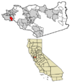
A map showing El Cerrito's location in Contra Costa County.
See also
 In Spanish: El Cerrito (condado de Contra Costa) para niños
