Fairfax Line facts for kids
The Fairfax Line was a special boundary line drawn in 1746. It helped mark the edges of a huge piece of land in old Virginia. This land was called the "Northern Neck land grant" or "Fairfax Grant."
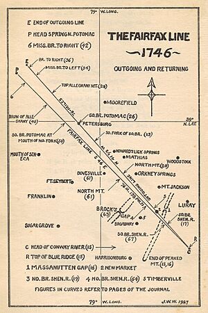
This land grant started way back in 1649. It included all the land between the Potomac and Rappahannock Rivers. That's a massive area, about 5,282,000 acres (21,375 square kilometers)! By 1719, a man named Thomas Fairfax, 6th Lord Fairfax of Cameron owned these lands. But people were arguing a lot about where the exact borders of his land were. In 1745, a decision was made. A new line would be drawn between the start of the North Branch Potomac River and the start of the Rappahannock River. This line would be the western edge of Lord Fairfax's property.
Contents
History of the Fairfax Land Grant
How the Grant Started
The Northern Neck Grant, often called the "Fairfax Grant," began in 1649. At that time, King Charles II of Britain was living in exile. He decided to reward some loyal friends. He gave them a large part of Virginia. This land was "bounded by and within the heads of the Rivers Rappahannock and Patawomecke."
The grant became official when Charles II became king again in 1660. It was recorded, and a "Proprietary" area was created in the New World. Back then, people hadn't explored all the land in the grant. So, they didn't know exactly what it covered.
Over time, the ownership of these lands changed. Eventually, they went to Thomas Fairfax, 5th Lord Fairfax of Cameron. He married Catherine, who was the only child of Thomas Colepeper, 2nd Baron Colepeper. This is why the Northern Neck grant is usually called the "Fairfax Grant."
Arguments Over the Borders
The government of Virginia often disagreed about where the Fairfax Grant ended. In 1745, a special group in London called the Privy Council made a big decision. They said that Lord Fairfax's land started at the first spring of the South Branch of the Rappahannock River. This spring was also known as the Conway River.
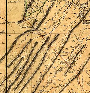
From there, the border would go in a straight line northwest. It would reach the Allegheny Mountains. There, it would meet the spot where the Potomac River (also called Cohongoroota) first started. This imaginary line between the Conway River's source and the North Branch Potomac River's source is what we call "the Fairfax Line."
Mapping the Line with Surveys
In 1736, a surveyor named John Savage and his team found where the North Branch Potomac River began. This was the northern border of the land. But they didn't try to mark the western borders of Lord Fairfax's land at that time.
Then, in 1746, a new survey was done. This was the "Survey of the Fairfax Line." Colonel Peter Jefferson (who was the father of Thomas Jefferson) and Thomas Lewis led this difficult job. They worked in very tough conditions.
Their survey led to two important things. First, they placed a special marker called the "Fairfax Stone" at the source of the river. Second, they officially marked the Fairfax Line. This line stretched from the Stone southeast to the start of the Conway River. Thomas Lewis kept a journal during this trip. It gives a clear picture of how incredibly hard it was to travel through the wild Allegheny Mountains back then.
Geography of the Fairfax Line
The Fairfax Line runs northwest for about 77 miles (124 kilometers). It goes through very rugged land. It starts from the top of the Blue Ridge Mountains in Virginia. Then it crosses to the top of the Allegheny Mountains in West Virginia. Along the way, it passes the headwaters of the Shenandoah River.
The southeast end of the line is at the source of the Conway River. This river flows into the Rappahannock. The source is on the eastern side of the Blue Ridge Mountains. It's near mile marker 55 on the Skyline Drive. This is about 30 miles (48 kilometers) north of Charlottesville, Virginia. It's also where the Virginia counties of Page, Madison, and Greene meet.
In the Shenandoah Valley, the line matches the southern border of the town of New Market, Virginia. It also marks the border between the Virginia counties of Rockingham and Shenandoah. As it continues northwest, the line marks the state border between Hardy County, West Virginia and Rockingham County, Virginia. It also goes through the city of Petersburg, West Virginia.
The northwest end of the line is at the Fairfax Stone. This stone marks the source of the North Branch of the Potomac River. The stone is located where the present-day West Virginia counties of Preston, Tucker, and Grant meet. It's also one mile south of the southwestern tip of Maryland Panhandle.
 | James Van Der Zee |
 | Alma Thomas |
 | Ellis Wilson |
 | Margaret Taylor-Burroughs |


