Fleming County, Kentucky facts for kids
Quick facts for kids
Fleming County
|
|
|---|---|

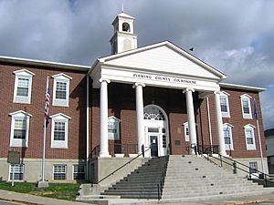
Fleming County courthouse in Flemingsburg
|
|

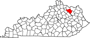
Location within the U.S. state of Kentucky
|
|
 Kentucky's location within the U.S. |
|
| Country | |
| State | |
| Founded | 1798 |
| Named for | John Fleming (1735–1791), early settler of Kentucky |
| Seat | Flemingsburg |
| Largest city | Flemingsburg |
| Area | |
| • Total | 351 sq mi (910 km2) |
| • Land | 349 sq mi (900 km2) |
| • Water | 2.8 sq mi (7 km2) 0.8%% |
| Population
(2020)
|
|
| • Total | 15,082 |
| • Estimate
(2023)
|
15,442 |
| • Density | 42.97/sq mi (16.590/km2) |
| Time zone | UTC−5 (Eastern) |
| • Summer (DST) | UTC−4 (EDT) |
| Congressional district | 6th |
Fleming County is a county in the U.S. state of Kentucky. In 2020, about 15,082 people lived there. The main town and county seat is Flemingsburg.
The county was started in 1798. It was named after Colonel John Fleming. He was an early settler and military figure in Kentucky. In 1998, Kentucky officially called Fleming County the "Covered Bridge Capital" of the state.
Contents
History of Fleming County
Fleming County was created in 1798. It was formed from land that used to be part of Mason County.
The first building used as a courthouse might have been made of logs. This building was later replaced in 1830. The courthouse was built again in 1952.
Geography and Location
According to the United States Census Bureau, Fleming County covers about 351 square miles (909 square kilometers). Most of this area, about 349 square miles (904 square kilometers), is land. Only a small part, about 2.8 square miles (7.3 square kilometers), is water.
Neighboring Counties
Fleming County shares its borders with several other counties. These are like its neighbors on a map.
- Mason County (to the north)
- Lewis County (to the northeast)
- Rowan County (to the southeast)
- Bath County (to the south)
- Nicholas County (to the west)
- Robertson County (to the northwest)
Population of Fleming County
The number of people living in Fleming County has changed over many years. Here is a look at the population from different census counts:
| Historical population | |||
|---|---|---|---|
| Census | Pop. | %± | |
| 1800 | 5,016 | — | |
| 1810 | 8,947 | 78.4% | |
| 1820 | 12,186 | 36.2% | |
| 1830 | 13,499 | 10.8% | |
| 1840 | 13,268 | −1.7% | |
| 1850 | 13,914 | 4.9% | |
| 1860 | 12,489 | −10.2% | |
| 1870 | 13,398 | 7.3% | |
| 1880 | 15,221 | 13.6% | |
| 1890 | 16,078 | 5.6% | |
| 1900 | 17,074 | 6.2% | |
| 1910 | 16,066 | −5.9% | |
| 1920 | 15,614 | −2.8% | |
| 1930 | 12,931 | −17.2% | |
| 1940 | 13,327 | 3.1% | |
| 1950 | 11,962 | −10.2% | |
| 1960 | 10,890 | −9.0% | |
| 1970 | 11,366 | 4.4% | |
| 1980 | 12,323 | 8.4% | |
| 1990 | 12,292 | −0.3% | |
| 2000 | 13,792 | 12.2% | |
| 2010 | 14,348 | 4.0% | |
| 2020 | 15,082 | 5.1% | |
| 2023 (est.) | 15,442 | 7.6% | |
| U.S. Decennial Census 1790-1960 1900-1990 1990-2000 2010-2020 |
|||
In 2000, there were about 13,792 people living in the county. This meant there were about 39 people for every square mile (15 people per square kilometer). There were also about 6,120 homes.
Most people in the county were White. About 1.41% were Black or African American. A small number of people were from other racial backgrounds. About 0.75% of the population identified as Hispanic or Latino.
The average age of people in the county was 36 years old. For every 100 females, there were about 96 males.
Towns and Communities
Fleming County has a few towns and many smaller communities.
Cities
Census-designated place
Unincorporated communities
These are smaller places that are not officially cities or towns.
- Bald Hill
- Beechburg
- Blue Bank
- Colfax
- Concord
- Cowan
- Craintown
- Dalesburg
- Fairview
- Foxport
- Fox Valley
- Goddard
- Grange City
- Hillsboro
- Hilltop
- Johnson Junction
- Mount Carmel
- Muses Mills
- Nepton
- Pleasureville
- Plummers Landing
- Poplar Grove
- Poplar Plains
- Ringos Mills
- Sherburne
- Tilton
- Wallingford
Famous People from Fleming County
Several notable people have come from Fleming County.
- Herman Chittison - A talented jazz pianist.
- Edward Alvin Clary - A brave US Navy member who received the Medal of Honor.
- Willis A. Gorman - A general in the Union Army during the American Civil War. He also served in the U.S. House of Representatives for Indiana and was a governor of Minnesota.
- Claiborne Fox Jackson - A governor of Missouri during the early part of the Civil War.
- Alvin Saunders - A United States senator who represented Nebraska.
- Franklin Sousley - One of the six men who helped raise the American flag on Iwo Jima during World War II.
- Andrew T. Wood - A lawyer and a politician.
See also
 In Spanish: Condado de Fleming para niños

