Frontenac State Park facts for kids
Quick facts for kids Frontenac State Park |
|
|---|---|
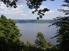
View of Lake Pepin from Frontenac State Park
|
|
| Location | Goodhue, Minnesota, United States |
| Area | 2,270 acres (9.2 km2) |
| Elevation | 692 ft (211 m) |
| Established | 1957 |
| Governing body | Minnesota Department of Natural Resources |
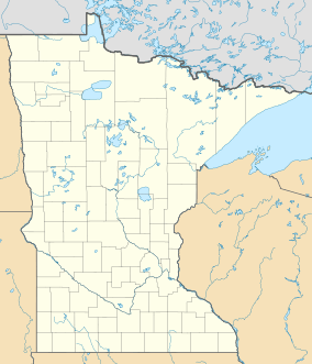
Frontenac State Park is a beautiful state park in Minnesota, United States. It sits right on the Mississippi River, about 10 miles (16 km) southeast of Red Wing. This park is special for its rich history and amazing opportunities to watch birds.
The most famous part of the park is a tall, steep limestone bluff. It's about 430-foot-high (130 m) and 3-mile-long (4.8 km). This bluff looks out over Lake Pepin, which is a naturally wider part of the Mississippi River. People call the bluff "Garrard's Bluff" or "Point No-Point." Riverboat captains gave it the second name because it looked like it stuck out into the river, even though it didn't.
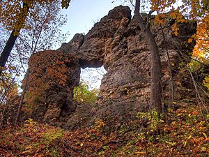
At the top of the bluff, there's a cool natural rock arch called In-Yan-Teopa. This is a Dakota name that means "Rock With Opening." The park lands completely surround the small town of Frontenac. This town used to be a fancy resort in the late 1800s.
Contents
Discovering Frontenac's Amazing Geology
The rocks you see at Frontenac State Park tell an old story. About 500 million years ago, this area was covered by a shallow sea. Tiny bits of dead plants and animals settled to the bottom. Over time, these layers turned into the limestone rock we see today.
Much later, a huge river called Glacial River Warren flowed through here. This river carried massive amounts of water from melting glaciers during the last ice age. It carved out the valleys for the Minnesota River and the Mississippi River. This created the steep bluffs along the riverbanks. Sometimes, Glacial River Warren was so big that Garrard's Bluff would have been an island!
This area is also special because it's part of the Driftless Area of Minnesota. This means it wasn't covered by glaciers during the last ice age.
Today, a creek called Wells Creek flows through the park into Lake Pepin. This creek carries a lot of sand from the nearby hills. When the sand hits the slow-moving river water, it drops to the bottom. This forms a delta and a sandy strip of land called Sand Point. Downstream, the Chippewa River does the same thing on an even bigger scale. All this sand blocking the river is why the Mississippi widens into Lake Pepin.
Exploring Frontenac's Plant Life
The forests on the bluff are a mix of different trees. You'll find maples, basswoods, elms, oaks, and aspens. As you move away from the bluff, the forest changes. It becomes open meadows with some trees, and then turns into prairie grasslands.
At the eastern end of the park, near the water, there's a bottomland forest. This area is often wet. Here, you'll see cottonwoods, maples, and willows.
Animals and Birdwatching at Frontenac
Frontenac State Park is home to many different animals. You might spot deer, raccoons, coyotes, opossums, red foxes, woodchucks, beavers, and various ground squirrels.
The park is especially famous for birdwatching. It's located on the Mississippi Flyway, which is a major route for birds migrating (traveling) between their summer and winter homes. People have been watching birds here since 1900! Over 260 different kinds of birds have been seen in Frontenac State Park.
You can often see majestic Bald eagles and golden eagles flying around the bluff. The bottomland forest is a great place to find colorful warblers. Sand Point is a popular resting spot for migrating birds, including ruddy turnstones and sanderlings.
One interesting animal to know about is the timber rattlesnake. These snakes are rare in the park. They are only dangerous if you bother them, so it's best to leave them alone if you see one.
A Glimpse into Frontenac's Past
Long, long ago, people lived in this area. We know this because archaeologists have found old village sites and burial mounds. These belonged to the Hopewell culture, who lived here between 400 BCE and 300 CE. Later, the Dakota and Fox people lived in this region.
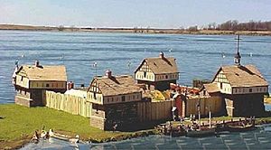
The first Europeans to visit were Father Louis Hennepin and his group in 1680. In 1727, a group from Montreal led by René Boucher came ashore. They built a fort called Fort Beauharnois. This fort was meant to be a trading post with the Dakota people. It was also a base for French explorers looking for a way to the Pacific Ocean. Several French forts were built around Lake Pepin. However, the French eventually gave this land to the British after the French and Indian War. Only one of these old forts has been found by archaeologists.
The first American settler was James "Bully" Wells. He had a fur trading post near what is now Frontenac town by 1840. Later, he sold his business to Evert Westervelt, a Dutch immigrant. But the Dakota people were moved to reservations, so Westervelt had to find new ways to make money. He teamed up with another settler, Israel Garrard, and they started a town in 1857. Westervelt named it after himself.
Two years later, Garrard bought out Westervelt and renamed the town Frontenac. He named it after Louis de Buade de Frontenac, who was a governor of New France a long time ago. Garrard fought in the American Civil War and became a general. After the war, he helped turn Frontenac into a summer resort for wealthy people. His brother, Jeptha Garrard, was an inventor who tried to fly machines from the bluff, but they didn't work. Rich visitors would arrive in Frontenac by steamboat from far away places like New Orleans.
At the same time, people were digging limestone out of the bluff. Some of this stone was even used to build the Cathedral of St. John the Divine in New York City! Frontenac's busy resort days ended when railroads became more popular than river travel in the late 1800s.
People started suggesting that Garrard's Bluff, Wells Creek, and Sand Point should be protected in the 1920s and 30s. But serious efforts didn't begin until a local group bought 160 acres (65 ha) in 1955. Their land more than doubled the next year when 200 acres (81 ha) of Garrard's Bluff were given by an insurance company chairman. This group worked hard to convince state lawmakers and other important people.
However, some people living in Frontenac were strongly against having a park. They worried that more visitors would ruin the town's quiet charm and disturb the wildlife. Their concerns were fair; at one point, there were plans for a "skyline drive" along the blufftop. A law to create the park passed in 1957. It included strict rules to limit how much the park could be developed for recreation. Buying the land from its owners was also difficult. The owner of Sand Point was especially stubborn, and some land had to be bought using eminent domain (where the government can buy private land for public use). Simple recreational facilities weren't added until the mid-1960s. More land has been added to the park over the years, but the idea of keeping it mostly natural has remained.
Fun Activities at Frontenac State Park
Frontenac State Park offers many ways to enjoy the outdoors:
- Camping: There's a campground on top of the bluff with 58 sites. 19 of these have electricity. There are also 6 walk-in campsites for a more rustic experience.
- Fishing: You can catch fish like walleye, northern pike, crappie, bluegill, and channel catfish in Lake Pepin.
- Sledding: In winter, there's a great hill behind the park office for sledding. A warming hut is nearby to help you stay cozy.
- Swimming: You can walk or boat to Sand Point for swimming. It's a very popular spot on warm summer weekends.
- Trails: The park has 13 miles (21 km) of hiking trails. In winter, 5.7 miles (9.2 km) are groomed for cross-country skiing, and 5.5 miles (8.9 km) are for snowmobiling.
- Bluffview Trail (hiking): This trail is a loop that goes below the blufftop. It has signs that explain interesting things about the park.
- Bluffside Trail (hiking): This trail follows the blufftop to In Yan Teopa. It then goes down in zig-zag turns to loop back along the side of the bluff. Three short paths lead to the rocky shore. Hiking this trail clockwise is a bit easier.
- Hill Trail (hiking/snowmobiling): This trail goes up through meadows and wooded areas from the park entrance to the campground. It's about 1.4 miles (2.3 km) long.
- Prairie Trail (hiking/skiing): This trail loops through prairie grasslands and oak forests. It also passes by the wooded shore of a small lake. It's about 2.7 miles (4.3 km) long.
- Sand Point Trail (hiking): This trail starts from a southern parking area. It goes through a bottomland forest to Sand Point, which is one of the best places in the park for birdwatching. It's about 0.7 miles (1.1 km) long.
- Indian Mound Trail (hiking): This is a short loop trail across the highway from the lower parking area. It passes by some old burial mounds. It's about 0.4 miles (0.6 km) long.
 | Aaron Henry |
 | T. R. M. Howard |
 | Jesse Jackson |


