Etowah County, Alabama facts for kids
Quick facts for kids
Etowah County
|
|||
|---|---|---|---|

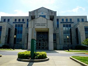
Etowah County Courthouse in Gadsden
|
|||
|
|||

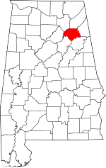
Location within the U.S. state of Alabama
|
|||
 Alabama's location within the U.S. |
|||
| Country | |||
| State | |||
| Founded | December 1, 1868 | ||
| Seat | Gadsden | ||
| Largest city | Gadsden | ||
| Area | |||
| • Total | 549 sq mi (1,420 km2) | ||
| • Land | 535 sq mi (1,390 km2) | ||
| • Water | 14 sq mi (40 km2) 2.5% | ||
| Population
(2020)
|
|||
| • Total | 103,436 | ||
| • Estimate
(2023)
|
103,241 |
||
| • Density | 188.41/sq mi (72.74/km2) | ||
| Time zone | UTC−6 (Central) | ||
| • Summer (DST) | UTC−5 (CDT) | ||
| Congressional district | 4th | ||
|
|||
Etowah County is a county in the northeastern part of Alabama. It is a state in the United States. In 2020, about 103,436 people lived there. The main city and government center is Gadsden.
The name "Etowah" comes from a Cherokee word. It means "edible tree." Etowah County is the smallest county in Alabama by land size. However, it has many people living in it for its size. The Gadsden area, which includes Etowah County, is a important center for jobs and living.
History
How Etowah County Was Formed
The land that is now Etowah County used to be part of other counties. Most of it belonged to DeKalb and Cherokee counties.
In 1866, after the American Civil War, a new county was created. It was called Baine County. It was named after General David W. Baine from the Confederate Army. Gadsden was chosen as its main city.
Name Change to Etowah
After the war, there were many changes and challenges in the state. In 1868, the county was changed again. It was renamed Etowah County. The name came from the Cherokee language. Most of the Cherokee people had been moved away from this area in the 1830s.
Palm Sunday Tornado
On Palm Sunday, March 27, 1994, a very strong tornado hit Etowah County. It was an F4 tornado, which means it was very powerful. It destroyed the Goshen United Methodist Church in Piedmont. This happened shortly after a tornado warning was issued for the area.
Geography
Land and Water
Etowah County covers about 549 square miles. Most of this is land, about 535 square miles. The rest, about 14 square miles, is water. This makes up about 2.5% of the county's total area. Etowah County is the smallest county in Alabama by land area.
Neighboring Counties
Etowah County shares borders with several other counties:
- DeKalb County to the north
- Cherokee County to the east
- Calhoun County to the southeast
- St. Clair County to the southwest
- Blount County to the west
- Marshall County to the northwest
Transportation
Public Transit
- Gadsden Trolley System
- Greyhound Lines (bus service)
Main Roads
Many important roads pass through Etowah County:
 Interstate 59
 Interstate 759
 U.S. Route 11
 U.S. Route 278
 U.S. Route 411
 U.S. Route 431
 State Route 77
 State Route 132
 State Route 179
 State Route 205
 State Route 211
 State Route 291
 State Route 759
Railroads
Trains also play a role in transportation here:
- Alabama and Tennessee River Railway
- Norfolk Southern Railway
- Tennessee, Alabama and Georgia Railway (This one is no longer in use)
Demographics
Population Over Time
| Historical population | |||
|---|---|---|---|
| Census | Pop. | %± | |
| 1870 | 10,109 | — | |
| 1880 | 15,398 | 52.3% | |
| 1890 | 21,926 | 42.4% | |
| 1900 | 27,361 | 24.8% | |
| 1910 | 39,109 | 42.9% | |
| 1920 | 47,275 | 20.9% | |
| 1930 | 63,399 | 34.1% | |
| 1940 | 72,580 | 14.5% | |
| 1950 | 93,892 | 29.4% | |
| 1960 | 96,980 | 3.3% | |
| 1970 | 94,144 | −2.9% | |
| 1980 | 103,057 | 9.5% | |
| 1990 | 99,840 | −3.1% | |
| 2000 | 103,459 | 3.6% | |
| 2010 | 104,430 | 0.9% | |
| 2020 | 103,436 | −1.0% | |
| 2023 (est.) | 103,241 | −1.1% | |
| U.S. Decennial Census 1790–1960 1900–1990 1990–2000 2010–2020 |
|||
The population of Etowah County has changed over many years. In 2020, the county had 103,436 people. There were about 40,053 households, which are groups of people living together.
Who Lives in Etowah County?
In 2010, about 80.3% of the people were White. About 15.1% were Black or African American. Other groups included Native American, Asian, and Pacific Islander people. About 3.3% of the population were Hispanic or Latino.
The average age of people in the county was about 40 years old.
Communities
Etowah County has several cities, towns, and other communities where people live.
Cities
- Attalla
- Boaz (partly in Marshall County)
- Gadsden (the county seat)
- Glencoe (partly in Calhoun County)
- Hokes Bluff
- Rainbow City
- Southside (partly in Calhoun County)
Towns
- Altoona (partly in Blount County)
- Reece City
- Ridgeville
- Sardis City (partly in Marshall County)
- Walnut Grove
Census-Designated Places
These are areas that are like towns but are not officially incorporated as cities or towns.
Other Communities
These are smaller, unincorporated places:
See also
 In Spanish: Condado de Etowah para niños


