Grantley Harbor facts for kids
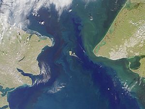
Grantley Harbor is a body of water in Alaska, a state in the United States. It's located on the Seward Peninsula, inside a larger bay called Port Clarence. The local people call it Kaviak. This inner harbor was named after a person called Lord Grantley.
Contents
History of Grantley Harbor
The area around Grantley Harbor, Port Clarence, and Golovnin Bay was once home to the Kaveahrachamutes people.
Early Expeditions and Stations
From 1865 to 1867, Grantley Harbor was an important base for the Russo-American Telegraph Expedition. This group was trying to build a telegraph line to connect America and Russia. Later, in 1892, the headquarters for the Teller Reindeer Station were set up nearby by Sheldon Jackson. This station helped introduce reindeer to Alaska.
The Nome Gold Rush
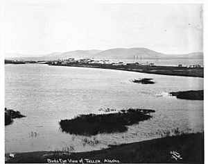
During the exciting time of the Nome Gold Rush, many gold seekers came to the town of Teller. This town is located right on Grantley Harbor. They hoped to find their fortune in gold.
Geography of Grantley Harbor
Grantley Harbor is an inner harbor. It opens into the northeast part of the larger Port Clarence bay.
Natural Features Around the Harbor
Two sandy areas at the entrance of the bay are called Points Spencer and Jackson. They were named after Navy officers. The land here is often wet and low, with many lakes. Point Spencer is a long, low sand spit that stretches about 10 miles from the coast. It forms the south and west sides of the harbor.
At the far eastern end of Port Clarence bay, two narrow sand spits reach out. These spits enclose Grantley Harbor. The entrance to the harbor is about 0.33 miles wide. The harbor itself is about 9 miles from east to west and 3 miles from north to south.
Connecting Waterways
At the very eastern end of Grantley Harbor, there's another narrow passage. It's about 900 feet wide and connects to a third body of water called Imourouk Lake. North of Grantley Harbor, a mountain called Muck-a-Charlie Peak rises to about 1600 feet.
On the eastern side of the harbor, a channel of water connects for about 3 to 4 miles. This channel passes between hills that are at least 100 feet high. The Agiapuk River flows alongside Grantley Harbor for about 20 miles, separated by higher land. The settlement of Nook used to be on the south side of the harbor's mouth. The water in the bay is deep enough for ships to travel easily.
Rivers and Creeks
The Bluestone River gold mining area is located south of the harbor. Several smaller streams flow into the harbor. These include Coyote, Dese, and Sunset creeks. The low, moss-covered land of Sunset Creek borders Grantley Harbor. Iglook Creek enters the harbor east of Sunset Creek.
There are also short streams, about 2 to 3 miles long, that flow into the harbor. Two come from the south, and four come from the north. They start in the Mokacharni Mountain area and flow through a hilly plateau.
Geology of Grantley Harbor
The rocks in the Grantley Harbor area are part of something called the Nome series. These include folded graphite slates. You can also find some coal veins in the valleys of the creeks that flow into the harbor.
Rock Formations
A look at the geological map shows a lot of greenstone in the eastern part of the bay. Scientists think this greenstone pushed its way into older limestone formations. These limestone formations are found below the slate. Limestone is also seen in the northern stream that flows into the harbor and to the west, near the Reindeer Station. Ordovician fossils have been found in these limestone formations.
The northern shore of the harbor has bedrock made of mica-schist and greenstone. The Mukhacharni Mountain and two mountains next to it have basaltic rocks. These rocks came from volcanoes and are very old, from before the Ice Age.
Minerals in Grantley Harbor
Gold was discovered in 1900 in three of the creeks that flow into the harbor. People quickly claimed these areas to mine. These rock formations also contain quartz with minerals. Gold has been taken from Sunset Creek (which is 5 miles long) and Igloo Creek as well.
Aquatic Life in Grantley Harbor
Grantley Harbor is home to many different kinds of aquatic animals.
Fish and Their Food
A large number of Pacific sandlance fish live in the harbor. They eat small sea creatures like crustaceans, barnacle larvae, copepods, and chaetognaths. These sandlance fish are a very important part of the food chain. They provide food for marine mammals, birds, and other fish.
Marine Mammals and Other Fish
You can spot different kinds of seals here, including spotted, ringed, and bearded seals. Spotted seals are often seen when the sea is calm. Seals and their oil are a main food source for people living in towns like Teller on the harbor's shores.
Other fish caught here include Herring, whitefish, starry flounder, pike, and tomcod. These are usually caught in spring, fall, and midsummer. All five types of salmon are found in the harbor. Red salmon are the most common catch. They travel inland to Salmon Lake to lay their eggs. Chum salmon migrate to the Pilgrim River and Agiapuk River. King salmon are not as common here.
Birds of Grantley Harbor
Many different bird species have been seen in Grantley Harbor. These include the Pelagic cormorant, pigeon guillemot, horned puffin, common eider, black scoter, Arctic terns, glaucous gulls, and White wagtails.
 | Delilah Pierce |
 | Gordon Parks |
 | Augusta Savage |
 | Charles Ethan Porter |


