Great Egg Harbor Bay facts for kids
Quick facts for kids Great Egg Harbor Bay |
|
|---|---|

Great Egg Harbor Bay facing west, with the Great Egg Harbor Bridge, Beesley's Point Generating Station, New Jersey Route 52, and the Rainbow Islands in background
|
|
| Location | Counties of Atlantic and Cape May in New Jersey |
| Coordinates | 39°18′15″N 74°38′59″W / 39.30417°N 74.64972°W |
| River sources | Great Egg Harbor River |
| Ocean/sea sources | Atlantic Ocean |
| Basin countries | United States |
| Max. length | 5.0 mi (8 km) |
| Max. width | 2.8 mi (4.5 km) |
| Surface area | 8.5 sq mi (22 km2) |
| Islands | Cowpens Island, Rainbow Islands |
| Settlements | Ocean City, Somers Point, Upper Township, Seaview Harbor, Longport |
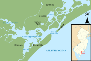
The Great Egg Harbor Bay is a large bay located between Atlantic and Cape May counties in southern New Jersey. Its name comes from a Dutch explorer named Cornelius Jacobsen May. In 1614, he saw many birds laying eggs here. He called the waters Eyren Haven, which means "Egg Harbor" in English. The bay covers an area of about 8.5 sq mi (22 km2). Its depth changes from very shallow areas, like Peck Bay, to a deep channel that is about 33 ft (10 m) deep.
The Great Egg Harbor River and its 17 smaller rivers (called tributaries) flow into the bay. Long ago, during a warm period between ice ages, the Great Egg Harbor River was a wide delta. This delta covered a large part of what is now Cape May County. Over time, the river changed its path. Now, it flows into the Atlantic Ocean through the Great Egg Harbor Inlet. This inlet is located between Ocean City and Longport. Along the coast, the bay stretches for about 5.0 mi (8 km). Ocean City borders the bay on its eastern side.
Contents
History of Great Egg Harbor Bay
Long, long ago, during a warm period between ice ages, melting glaciers created many rivers. These rivers carried sand and dirt to the Atlantic Ocean coast. The Great Egg Harbor River was once a big delta. It spread out over much of what is now Cape May County. Over time, the river settled into its current path. Today, the Great Egg Harbor River and its 17 smaller rivers flow into the Great Egg Harbor Bay. The bay then connects to the ocean at the Great Egg Harbor Inlet. This inlet is found between Ocean City and Longport.
The first people to live in this area were the Leni-Lenape. They would fish, gather clams, and swim in the bay during the summer. In 1614, a Dutch explorer named Cornelius Jacobsen May found the bay. He saw many birds laying eggs there. May decided to call the water Eyren Haven, which means "Egg Harbor."
In 1693, the court of Cape May County asked John Somers to run a ferry service. This ferry would cross the Great Egg Harbor Bay to Cape May County. That same year, Somers bought land from Thomas Budd. He named his new property Somerset Plantation. John Somers' son, Richard, built Somers Mansion between 1720 and 1726. This house is still the oldest one in the county. The town's name changed a few times. It was called Somers Ferry, then Somers Plantation. Finally, the name Somers Point became official in 1750. During the 1600s and 1700s, pirates and other sailors used Great Egg Harbor Bay as a safe place. In 1880, regular steamboat service started from Somers Point. This was one year after Ocean City was founded as a Christian resort. In 1897, the eastern edges of Peck Bay and Great Egg Harbor Bay became the official borders for the new Ocean City.
Bridges and Crossings Over the Bay
In 1907, a train line called the Atlantic City and Shore Railroad started running. It went from Atlantic City to Ocean City, passing through Somers Point. The railroad bridge over the Great Egg Harbor Bay burned down in 1946. It was never rebuilt, and the train line stopped running in 1948.
In 1914, a company built a toll bridge connecting Somers Point and Ocean City. This was called the Ocean City Automobile Bridge. In 1921, the state of New Jersey bought the bridge, making it free to use. A new bridge, the World War Memorial Bridge, replaced it in 1933. This bridge, known as New Jersey Route 52, was later replaced by an even wider and taller bridge in 2012.
Another bridge opened in 1928 in northern Ocean City. It crossed the Great Egg Harbor Inlet to the marshlands in Atlantic County. Also in 1928, the Ocean City Automobile Club helped build the Beesley's Point Bridge. This bridge connected Somers Point to Beesley's Point, New Jersey across the Great Egg Harbor Bay. This bridge was closed in 2004 because it was damaged. It was taken down in 2016.
In 1955, the Great Egg Harbor Bridge was built. Later, in 1973, another bridge was added next to it for northbound traffic on the Garden State Parkway. The 1955 bridge was replaced in 2016. The northbound bridge was then fixed up, with work finishing in 2019.
Features of Great Egg Harbor Bay
At the top, or "head," of the Great Egg Harbor Bay, the Great Egg Harbor River meets the Middle and Tuckahoe Rivers. This happens between Upper Township and Egg Harbor Township. The bay is part of New Jersey's natural lagoon system, which is behind the barrier islands. The bay is actually a "drowned" river valley, meaning it was once a river valley that became covered by water.
The bay covers about 8.5 sq mi (22 km2). It stretches about 5.0 mi (8 km) along the coast. It also reaches about 2.8 mi (4.5 km) inland. The water level changes with the tide. A high tide (spring tide) can raise the water by 5.0 ft (1.52 m). A low tide (neap tide) can lower it by 2.3 ft (0.7 m). Big coastal storms can cause even bigger changes in water levels.
The bay's salinity (how salty it is) ranges from 17 to 32 parts per thousand. This means it's quite salty. The water in the bay moves in a counterclockwise direction. This movement is helped by the deep channels. The water quality is generally good, even with towns nearby. However, stormwater from Ocean City flows directly into the bay.
Next to the bay are about 18,932 acres (7,662 ha) of salty marshes. In the western part of the bay, these marshes are part of the Lester G. McNamara Wildlife Management Area. The bay also has sandy beaches and towns along its edges. The water depth in the bay varies. It can be less than 3.3 ft (1 m) deep in some spots. But in the main water channel, it can be more than 33 ft (10 m) deep. This channel goes from the Great Egg Harbor Inlet to where the Tuckahoe and Great Egg Harbor rivers meet.
The channels in the bay carry sand and shell pieces towards the Great Egg Harbor Inlet. At the inlet, the changing currents can make it tricky for boats. This is because the sand shifts, creating shallow areas. To make it easier for boats and to add sand to the beaches in Ocean City, the United States Army Corps of Engineers sometimes digs up sand from the ocean floor. This happens about 5,000 ft (1,500 m) offshore from the Great Egg Harbor Inlet.
Peck's Bay is a shallow part of Great Egg Harbor Bay. It's located on the southern side, between Ocean City and the mainland of Cape May County. Peck's Bay is also part of the Intracoastal Waterway. This waterway connects Great Egg Harbor Bay with Crook Horn Creek. This water path runs along the west side of Ocean City. It reaches the ocean at Corson Inlet and continues south through Cape May County.
Islands in the Bay
The rivers flowing into the bay bring a lot of sand and mud. This creates shoals (shallow areas) and mudflats. These areas rise out of the bay to form many marshy islands. These islands are slowly getting smaller. They are eroding (wearing away) by about 0.28 in (7 mm) each year. This is due to rising sea levels. From 1940 to 1991, the islands shrank by 5%.
Some of the biggest islands include Cowpens Island and Shooting Island. Both are next to Ocean City. Shooting Island has been eroding since at least 1930. In 2018, a company started a project to help restore it. They installed concrete blocks to protect oysters and rebuild the island's marshes. In the middle of the bay are the Rainbow Islands. They cover about 250 acres (100 ha) in total. However, they are underwater during high tide. Cowpens Island is also located next to Ocean City.
Bay Ecosystem: Plants and Animals
The bay's water and channels carry silt, which creates a soft bottom. This soft bottom is a great home for shellfish, covering an area of about 706 acres (286 ha). Other small creatures without backbones, called invertebrates, also live in the bay. These include mussels, barnacles, amphipods, mysids, and different kinds of worms. In the shallow parts of the bay, where sunlight can reach the bottom, you can find algae and seagrasses growing.
The bay is an important place for hard clams and oysters to lay their eggs and grow. There are 32 different kinds of fish in the bay. Six of these fish species use the bay as a place to lay their eggs. The endangered Leatherback sea turtle and other types of turtles live in the coastal waters of New Jersey, including in the bay. Many different bird species use the water and the nearby marsh lands as places to build nests and raise their young. Cowpens Island, which is in the bay, is a special bird sanctuary. It's also a rookery (a place where many birds nest) for herons. This area is one of the top 20 places in the country for migratory birds (birds that travel long distances).
Industry and Activities
By the 1700s, Somers Point had several shipyards along the Great Egg Harbor Bay. These shipyards were important for building boats and ships. Today, people are allowed to harvest shellfish from the bay. This usually happens from November 1st to April 30th. Riding Jet Skis is a popular activity on the bay during the summer months.
The barrier islands to the north and south of the bay, Ocean City and Longport, have a lot of buildings. Many bulkheads (walls built along the shore) have been added. These change the natural coastline of the bay.
 | Madam C. J. Walker |
 | Janet Emerson Bashen |
 | Annie Turnbo Malone |
 | Maggie L. Walker |


