
Green Creek (Fishing Creek tributary) facts for kids
Quick facts for kids Green Creek |
|
|---|---|
_in_springtime.JPG)
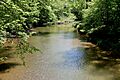
the lower reaches of Green Creek in late spring
|
|
| Physical characteristics | |
| Main source | hill near Waller in Jackson Township, Columbia County, Pennsylvania 1,246 ft (380 m) |
| River mouth | Fishing Creek in Orange Township, Columbia County, Pennsylvania 561 ft (171 m) |
| Length | 12.7 mi (20.4 km) |
| Basin features | |
| Progression | Fishing Creek → Susquehanna River → Chesapeake Bay |
| Basin size | 36.8 sq mi (95 km2) |
| Tributaries |
|
Green Creek is a stream located in Columbia County, Pennsylvania, in the United States. It flows into Fishing Creek. The creek is about 12.7 miles (20.4 km) long. It flows through three townships: Jackson Township, Greenwood Township, and Orange Township. The area of land that drains into Green Creek, called its watershed, is about 36.8 square miles (95 km2).
Green Creek gets its name because its water often looks green. This color becomes even more noticeable in the summer when plants on its banks reflect in the water. The creek is considered healthy and is not listed as a polluted waterway. It adds a lot of water to Fishing Creek. A famous covered bridge called the Patterson Covered Bridge crosses Green Creek. People started settling near the creek in the late 1700s and early 1800s. Over time, several mills were built along its banks. The creek is also a good place for fishing, especially for trout.
Contents
Where Green Creek Flows

Green Creek starts on a hill near a place called Waller in Jackson Township. It flows south, passing through Waller, and then turns southwest. Along its path, it flows through several small ponds. The creek continues generally south and southwest, moving through a valley.
After a while, Green Creek enters Greenwood Township. Here, it flows past O'Brien Hill and Kramer Hill, often running next to Pennsylvania Route 254. Its valley becomes wider as it reaches Rohrsburg. In Rohrsburg, it crosses Pennsylvania Route 254 and is joined by its first named smaller stream, Little Green Creek, from the right side.
The creek then turns in different directions before another stream, Rickard Hollow, joins it from the left. After leaving Rohrsburg, Mud Run joins Green Creek from the right, and the creek enters Orange Township. In Orange Township, Green Creek flows alongside Rohrsburg Road. Its valley becomes deeper and narrower again. It passes by Round Top and then flows into the flat area shared with Fishing Creek. Finally, Green Creek meets Fishing Creek about 10.84 miles (17.45 km) upstream from where Fishing Creek ends.
Green Creek's Tributaries
Green Creek has three named smaller streams that flow into it: Mud Run, Rickard Hollow, and Little Green Creek.
- Mud Run joins Green Creek about 3.06 miles (4.92 km) before its mouth. It drains an area of 13.3 square miles (34 km2).
- Rickard Hollow joins Green Creek about 3.56 miles (5.73 km) before its mouth. It drains an area of 2.22 square miles (5.7 km2).
- Little Green Creek joins Green Creek about 4.16 miles (6.69 km) before its mouth. It drains an area of 5.01 square miles (13.0 km2).
Water Flow and Health

Green Creek is considered a healthy stream and is not listed as a polluted waterbody. Its waters significantly increase the amount of water flowing in Fishing Creek, especially in Orange Township. Long ago, in 1841, people described Green Creek as a "considerable stream" with strong water power.
Scientists have measured how much water flows in Green Creek at different points.
- In its upper parts, where the stream drains an area of 2.55 square miles (6.6 km2), the average daily water flow was about 4.44 cubic feet per second (0.126 m3/s).
- Further downstream, draining 9.42 square miles (24.4 km2), the average flow was about 16.40 cubic feet per second (0.464 m3/s).
- In its lower parts, draining 33.24 square miles (86.1 km2), the average flow was about 57.87 cubic feet per second (1.639 m3/s).
Land and Rocks Around the Creek
The land around the mouth of Green Creek is about 561 feet (171 m) above sea level. The source of the creek is higher, around 1,246 feet (380 m) above sea level.
A valley called the Greenwood Valley lies between Green Creek and Little Fishing Creek in southern Greenwood Township. Green Creek is located in a type of landscape known as the Ridge And Valley region. This area has many hills and hollows between Fishing Creek and Green Creek.
In the past, there was a large whirlpool on Green Creek, about 2 miles (3.2 km) south of Rohrsburg. It was known as the Spinning Wheel or the Witch's Kettle. It was thought to be about 60 feet (18 m) wide and over 200 feet (61 m) deep. Over time, trash was thrown into it, and floods changed the creek's path. Now, a road covers the spot where the whirlpool used to be.
During the Ice Age, glaciers might have moved down the valley of Green Creek. Evidence of these ice movements, like drift (rocks and soil left by glaciers) and cobbles (rounded stones), can be found along the creek's valley, sometimes as high as 100 feet (30 m) above the valley floor.
Green Creek's Watershed
.JPG)
The entire area of land that drains into Green Creek, its watershed, covers about 36.8 square miles (95 km2). The mouth of the creek is shown on the Bloomsburg map from the United States Geological Survey, while its source is on the Benton map.
Soil erosion is a problem in some parts of Green Creek's watershed, especially in the Greenwood Valley. This valley is used quite a lot for agriculture. In 2015, a project worked to stabilize 300 feet (91 m) of the creek's banks in Jackson Township to help prevent erosion.
History of the Creek
Green Creek was officially added to the Geographic Names Information System on August 2, 1979. Its name comes from the greenish look of its water.
Long ago, a Native American path connected the Wyoming Valley to Muncy. This path followed Green Creek from its mouth upstream to near Rohrsburg. In 1778, a scout named Moses Van Campen traveled along the headwaters of Green Creek.
In the late 1700s and early 1800s, families like the Mathers and Jacob Lunger settled near Green Creek. Abram Whiteman settled at the creek's source in 1805. Early settlers built different types of mills on the creek. Abram Kline built a sawmill, and Joseph Fullmer built the first flouring mill in the Rohrsburg area on Green Creek. Later, a fulling and carding mill operated on the creek near Rohrsburg. In the 1800s, a school district in Greenwood Township was even named the Green Creek District because the creek flowed through it.
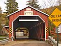
The Patterson Covered Bridge was built over Green Creek in 1875 by Frank Derr. It cost $804 and was named after a nearby sawmill. Many other bridges have been built over Green Creek over the years to help people cross it.
Animals and Plants
The area that drains into Green Creek is a special place for fish. It's called a Trout Stocked Fishery and a Migratory Fishery. This means it's a good place for trout, and other fish that travel to different waters. Wild trout naturally live and reproduce in almost the entire length of the creek, from its source down to its mouth, a distance of about 12.30 miles (19.79 km). In the late 1990s, brown trout were seen in the creek.
A specific area called the Green Creek Floodplain is important for nature. It's listed as a "locally significant site" because it has a section of the creek's floodplain covered with hemlock trees in Jackson Township. Other important natural areas might also exist along the creek in Greenwood Township.
Some parts of Green Creek have narrow riparian buffers. These are strips of plants and trees along the banks that help protect the water. Making these buffers wider would be good for the creek. As of 2004, a plant called purple loosestrife has been growing and spreading along the creek.
Images for kids
-
the lower reaches of Green Creek in late spring
-
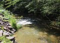
Green Creek looking downstream in Jackson Township
-
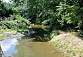
Green Creek looking downstream in Rohrsburg
-
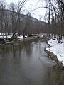
Green Creek in late winter
-
Patterson Covered Bridge over Green Creek

