Grottoes, Virginia facts for kids
Quick facts for kids
Grottoes, Virginia
|
||
|---|---|---|
|
Town
|
||
|
||

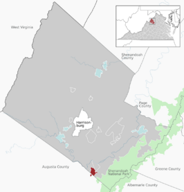
Location of Grottoes within the Rockingham County
|
||
| Country | United States | |
| State | Virginia | |
| Counties | Rockingham, Augusta | |
| Area | ||
| • Total | 2.07 sq mi (5.37 km2) | |
| • Land | 2.04 sq mi (5.28 km2) | |
| • Water | 0.04 sq mi (0.09 km2) | |
| Elevation | 1,112 ft (339 m) | |
| Population
(2010)
|
||
| • Total | 2,668 | |
| • Estimate
(2019)
|
2,860 | |
| • Density | 1,402.65/sq mi (541.56/km2) | |
| Time zone | UTC-5 (Eastern (EST)) | |
| • Summer (DST) | UTC-4 (EDT) | |
| ZIP code |
24441
|
|
| Area code(s) | 540 | |
| FIPS code | 51-33488 | |
| GNIS feature ID | 1495628 | |
| Website | Official website: https://www.townofgrottoes.com/ | |
Grottoes is a town in the state of Virginia, USA. It is located in both Rockingham and Augusta counties. In 2020, about 2,899 people lived there.
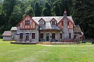
Grottoes is special because it's home to Grand Caverns. This is America's oldest show cave, meaning it has been open for tours since 1806!
Contents
History of Grottoes
The town of Grottoes has an interesting history with different names.
Early Names and Founding
In the 1880s, the area was first known as Liola. Then, in 1889, it was briefly called Grottoes. The word "grottoes" means "caves," which makes sense because of the famous caverns nearby.
In 1892, a group of people who bought and sold land officially started a town called Shendun. This name was a mix of "Shenandoah" (from the nearby Shenandoah River) and "dun," an old word meaning 'castle' or 'fortified hill'.
Changes and Official Name
The company that founded Shendun faced money problems and went out of business in 1893. On March 11, 1912, the town's name was officially changed back to Grottoes.
Growth and Development
Grottoes is located between the South Fork of the Shenandoah River and Brown's Gap. This location made it easy for people to travel to nearby towns and use natural resources.
In 1933, a special camp was set up near Grottoes. It was for the Civilian Conservation Corps (CCC). The CCC was a program that helped young men find work during tough economic times. They built trails and roads in Shenandoah National Park that are still used today.
During World War II, this former CCC camp became a place for people who chose not to fight in the war for their beliefs. About 100 young men, many of them Mennonite, lived and worked there. They helped with things like soil conservation, forestry, and land recovery.
In 1973, the National Park Service recognized Grand Caverns as a National Natural Landmark. This means it's a very important natural site. Also, the Stephen Harnsberger House was added to the National Register of Historic Places in 1982, recognizing its historical value.
Geography of Grottoes
Grottoes is located in the beautiful Shenandoah Valley. It covers about 1.3 square miles (3.4 square kilometers) of land.
Location and Nearby Areas
The town's location is a big advantage. It is within 15 miles (24 km) of several other towns like Waynesboro, Staunton, Harrisonburg, and Elkton. Grottoes is also about 43 miles (69 km) from Charlottesville.
Natural Features
The area around Grottoes has many interesting natural landmarks. These include Skyline Drive, a famous scenic road, Massanutten Peak, and Natural Chimneys, which are tall, natural rock formations.
Transportation in Grottoes
Getting around Grottoes and to other places is made easy by its main roads.
Major Highways
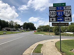
The two main highways that go through Grottoes are U.S. Route 340 and Virginia State Route 256.
- US 340 runs north and south. It connects Grottoes to Interstate 64 near Waynesboro and U.S. Route 33 near Elkton.
- SR 256 comes from the west. It connects to Interstate 81 near Weyers Cave.
Historical Transport Routes
In the past, people traveled through Brown's Gap to the east. Trains also used to run on the Norfolk Southern line, which was once called the Shenandoah Valley Railroad. People could also travel by water on the South Fork of the Shenandoah River to nearby Port Republic. From there, they could go all the way to Harpers Ferry, WV.
Population and People
The town of Grottoes has grown quite a bit over the years.
| Historical population | |||
|---|---|---|---|
| Census | Pop. | %± | |
| 1900 | 381 | — | |
| 1910 | 456 | 19.7% | |
| 1920 | 492 | 7.9% | |
| 1930 | 534 | 8.5% | |
| 1940 | 759 | 42.1% | |
| 1950 | 908 | 19.6% | |
| 1960 | 969 | 6.7% | |
| 1970 | 1,166 | 20.3% | |
| 1980 | 1,369 | 17.4% | |
| 1990 | 1,455 | 6.3% | |
| 2000 | 2,114 | 45.3% | |
| 2010 | 2,668 | 26.2% | |
| 2019 (est.) | 2,860 | 7.2% | |
| U.S. Decennial Census | |||
As of the 2020 census, there were 2,899 people living in Grottoes. The town had 1,283 households.
Most people in Grottoes are White (86.16%). About 7.07% are Hispanic or Latino, and 4.07% are African American. Other groups make up smaller parts of the population.
The average household in Grottoes has about 2.46 people. The median age in the town is 38 years old. This means half the people are younger than 38 and half are older.
Famous People from Grottoes
Some well-known people have connections to Grottoes:
- Daryl Irvine – a former baseball player who was a relief pitcher for the Boston Red Sox.
- Dell Curry – a former NBA player, famous for playing with the Charlotte Hornets.
See also
 In Spanish: Grottoes (Virginia) para niños


