
Bar Harbor, Maine facts for kids
Bar Harbor is a fun resort town located on Mount Desert Island in Maine, United States. In 2020, about 5,089 people lived there. It's home to cool places like the College of the Atlantic and the Jackson Laboratory.
During summer and fall, Bar Harbor is a very popular spot for tourists. It's also where you'll find most of Acadia National Park, including Cadillac Mountain. This mountain is the highest point near the coastline in the eastern United States!
You can get to Bar Harbor by road using Maine State Route 3. You can also fly into Hancock County–Bar Harbor Airport or take a ferry from Winter Harbor, Maine, or Yarmouth, Nova Scotia.
Quick facts for kids
Bar Harbor, Maine
Man-es-ayd'ik, Ah-bays'auk
|
||
|---|---|---|

Main Street
|
||
|
||

Bar Harbor, Maine
Location in Maine

Bar Harbor, Maine
Location in the United States
|
||
| Country | United States | |
| State | Maine | |
| County | Hancock | |
| Settled | 1763 | |
| Incorporated | February 23, 1796 | |
| Villages | Eden (until March 3, 1918) Bar Harbor (from March 3, 1918) Hamilton Station Hulls Cove Indian Point Red Rock Corner Salsbury Cove Town Hill |
|
| Government | ||
| • Type | Council-Manager | |
| Area | ||
| • Total | 63.11 sq mi (163.45 km2) | |
| • Land | 42.24 sq mi (109.40 km2) | |
| • Water | 20.87 sq mi (54.05 km2) | |
| Population
(2020)
|
||
| • Total | 5,089 | |
| • Density | 120/sq mi (46.5/km2) | |
| Time zone | UTC−5 (Eastern (EST)) | |
| • Summer (DST) | UTC−4 (EDT) | |
| ZIP Code |
04609
|
|
| Area code(s) | 207 | |
| Website | www.barharbormaine.gov | |

Contents
History of Bar Harbor
Early Days and Native People
Bar Harbor is on the northeast shore of Mount Desert Island. The Wabanaki Native Americans called this island Pemetic, meaning "range of mountains." They would come to the area to fish, hunt, and gather berries and shellfish. They called Bar Harbor Man-es-ayd'ik (clam-gathering place) or Ah-bays'auk (clambake place).
In 1604, French explorer Samuel de Champlain visited the island. He named it Isles des Monts Deserts, which means "island of barren mountains." This is how Mount Desert Island got its name.
In 1761, Abraham Somes started the first European village on the island, called Somesville. Bar Harbor itself was first named Eden in 1796, after an English statesman.
Growing into a Popular Resort
At first, people in Bar Harbor worked in fishing, lumbering, and shipbuilding. They also farmed, especially dairy. In the 1840s, artists like Thomas Cole and Frederic Edwin Church were inspired by the beautiful coastal scenery. Their paintings made more people want to visit.
The first hotel in Eden, Agamont House, opened in 1855. By 1880, there were 30 hotels! Wealthy and famous people started coming to Bar Harbor for their summer vacations. They built huge "cottages" and held fancy parties. They often hired Beatrix Farrand, a famous landscape designer, to create beautiful gardens.
People enjoyed Yachting, garden parties, and carriage rides up Cadillac Mountain. Even US President William Howard Taft played golf here in 1910.
On March 3, 1918, Eden was renamed Bar Harbor. This new name came from the sand and gravel bar that appears at low tide, connecting the town to Bar Island.

During World War II, Bar Harbor was used for naval practices. For example, Bald Porcupine Island was used to test torpedoes.
Many important people have lived in Bar Harbor. John D. Rockefeller Jr. donated a lot of land to create Acadia National Park and built the carriage roads there. Other famous families like the J. P. Morgans, Cornelius Vanderbilts, and Astor familys also had homes here.
The Big Fire of 1947
In October 1947, Maine had a very dry period. A wildfire started near Town Hill and spread quickly because of strong winds. It burned for ten days.
Almost half of the eastern side of Mount Desert Island was destroyed. This included 67 large "cottages" and five historic hotels. Over 10,000 acres (4,000 hectares) of Acadia National Park also burned. Luckily, the main business area of the town was saved.
Geography of Bar Harbor
Bar Harbor covers about 63.11 square miles (163.45 km2) of land and water. It sits on Frenchman Bay, with several small islands nearby.
A cool feature of Bar Harbor is the sandbar that gives the town its name. Twice a day, when the tide is low, this sandbar appears. You can walk across it to Bar Island!

Weather in Bar Harbor
Bar Harbor has a humid continental climate. This means it has big differences in temperature between seasons. Summers are warm to hot, and winters are cold, sometimes very cold. Even though it's on an island, the winds mostly come from the land, making the winters colder than you might expect for a coastal area.
| Climate data for Bar Harbor, Maine | |||||||||||||
|---|---|---|---|---|---|---|---|---|---|---|---|---|---|
| Month | Jan | Feb | Mar | Apr | May | Jun | Jul | Aug | Sep | Oct | Nov | Dec | Year |
| Record high °F (°C) | 63 (17) |
57 (14) |
78 (26) |
83 (28) |
92 (33) |
97 (36) |
96 (36) |
98 (37) |
96 (36) |
89 (32) |
70 (21) |
66 (19) |
98 (37) |
| Mean daily maximum °F (°C) | 31.4 (−0.3) |
35.0 (1.7) |
41.6 (5.3) |
53.3 (11.8) |
65.0 (18.3) |
74.2 (23.4) |
79.1 (26.2) |
78.4 (25.8) |
70.5 (21.4) |
58.7 (14.8) |
48.1 (8.9) |
37.2 (2.9) |
56.1 (13.4) |
| Daily mean °F (°C) | 22.6 (−5.2) |
26.1 (−3.3) |
33.2 (0.7) |
44.2 (6.8) |
54.7 (12.6) |
64.0 (17.8) |
69.2 (20.7) |
68.7 (20.4) |
61.2 (16.2) |
50.3 (10.2) |
40.5 (4.7) |
29.3 (−1.5) |
47.1 (8.4) |
| Mean daily minimum °F (°C) | 13.7 (−10.2) |
17.2 (−8.2) |
24.8 (−4.0) |
35.0 (1.7) |
44.5 (6.9) |
53.7 (12.1) |
59.3 (15.2) |
58.9 (14.9) |
52.0 (11.1) |
42.0 (5.6) |
33.0 (0.6) |
21.3 (−5.9) |
38.1 (3.4) |
| Record low °F (°C) | −20 (−29) |
−21 (−29) |
−9 (−23) |
11 (−12) |
22 (−6) |
32 (0) |
36 (2) |
36 (2) |
27 (−3) |
20 (−7) |
−3 (−19) |
−21 (−29) |
−21 (−29) |
| Average precipitation inches (mm) | 4.9 (120) |
4.4 (110) |
5.4 (140) |
4.8 (120) |
4.6 (120) |
4.1 (100) |
3.5 (89) |
3.3 (84) |
4.5 (110) |
5.3 (130) |
6.5 (170) |
5.5 (140) |
56.7 (1,440) |
| Average snowfall inches (cm) | 16.7 (42) |
18.7 (47) |
11.4 (29) |
4.1 (10) |
0.2 (0.51) |
0 (0) |
0 (0) |
0 (0) |
0 (0) |
0.2 (0.51) |
3.0 (7.6) |
12.5 (32) |
66.8 (170) |
| Average precipitation days | 11 | 9 | 10 | 10 | 10 | 10 | 9 | 8 | 9 | 9 | 10 | 10 | 115 |
| Source: Weatherbase | |||||||||||||
People and Education
| Historical population | |||
|---|---|---|---|
| Census | Pop. | %± | |
| 1800 | 400 | — | |
| 1810 | 657 | 64.3% | |
| 1820 | 764 | 16.3% | |
| 1830 | 957 | 25.3% | |
| 1840 | 1,054 | 10.1% | |
| 1850 | 1,127 | 6.9% | |
| 1860 | 1,247 | 10.6% | |
| 1870 | 1,195 | −4.2% | |
| 1880 | 1,629 | 36.3% | |
| 1890 | 1,946 | 19.5% | |
| 1900 | 4,379 | 125.0% | |
| 1910 | 4,441 | 1.4% | |
| 1920 | 3,622 | −18.4% | |
| 1930 | 4,486 | 23.9% | |
| 1940 | 4,378 | −2.4% | |
| 1950 | 3,864 | −11.7% | |
| 1960 | 3,807 | −1.5% | |
| 1970 | 3,716 | −2.4% | |
| 1980 | 4,124 | 11.0% | |
| 1990 | 4,443 | 7.7% | |
| 2000 | 4,820 | 8.5% | |
| 2010 | 5,235 | 8.6% | |
| 2020 | 5,089 | −2.8% | |
| sources: | |||
In 2010, Bar Harbor had 5,235 people living there. Most residents were White, with smaller numbers of African American, Native American, and Asian people. About 1.1% of the population was Hispanic or Latino.
Schools and Learning
- Conners Emerson School: This school in Bar Harbor teaches students from kindergarten to 8th grade.
- Mount Desert Island High School: This high school serves students from Bar Harbor and other towns on Mount Desert Island.
- College of the Atlantic: This college is also located in Bar Harbor.
Getting Around Bar Harbor
The main road to Bar Harbor is Maine State Route 3. It leads right into the town. Other important roads help you get around the area and into the national park.
Bar Harbor has its own airport, the Hancock County–Bar Harbor Airport. You can fly from here to Boston, Massachusetts, all year round.
You can also take a high-speed ferry called The CAT from Bar Harbor to Yarmouth, Nova Scotia, in Canada. The trip takes about 3.5 hours. There's also a summer ferry service across Frenchman Bay to Winter Harbor, Maine.
Fun Things to Do in Bar Harbor
Many people visit Bar Harbor from May to October. They come for Acadia National Park, which has amazing hiking trails and carriage roads. These are great for biking, bird watching, and mountain climbing. Cadillac Mountain is a popular spot for its views.
You can take boat tours to see puffins, whales, seals, and lighthouses. You can also learn about lobster fishing, which is a big part of the local economy.
Bar Harbor has many historic houses, including large "cottages" along the shore. Some of these have been turned into inns today.
In 2012, the Village Green was named one of the top ten Great Public Places in America. It's a nice spot to relax.
Many cruise ships visit Bar Harbor, especially in September and October. In 2022, the town voted to limit the number of cruise ship passengers to 1,000 per day to help with crowding.
Bar Harbor is also a popular place for long-distance cyclists. It's the end point for two major bike routes: the Northern Tier Bicycle Route and the Atlantic Coast Bicycle Route.
If you like ice cream, you're in luck! Mount Desert Island Ice Cream is known as one of the best ice cream shops in the country. Even President Obama and his family visited it! Another popular spot is Ben & Bill's Chocolate Emporium, famous for its unique lobster-flavored ice cream.
Famous Visitors

Many well-known people have lived in or visited Bar Harbor:
- Verna Bloom, actress
- David E. Kelley, television producer
- Shirley Povich, sports reporter
- David Rockefeller, banker
- Nelson Rockefeller, who was a businessman, governor of New York, and even Vice President of the United States.
- George Davis Snell, a scientist who won a Nobel Prize for his research at The Jackson Laboratory in Bar Harbor.
Images for kids
-
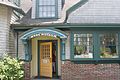
The Abbe Museum teaches about the history and culture of Maine's native people, the Wabanaki.

See also
 In Spanish: Bar Harbor (Maine) para niños
