
Hunter Island (Bronx) facts for kids

Northern tip of Hunter Island in Pelham Bay Park
|
|
| Etymology | John Hunter |
|---|---|
| Geography | |
| Location | New York City (Pelham Bay Park, the Bronx), United States |
| Coordinates | 40°52′34″N 73°47′24″W / 40.87611°N 73.79000°W |
| Archipelago | Pelham Islands |
| Adjacent bodies of water | Pelham Bay/Long Island Sound |
| Area | 166 acres (67 ha) |
| Highest elevation | 90 ft (27 m) |
| Additional information | |
| Official website | NYC Parks |
Hunter Island is a 166-acre piece of land in the Bronx, New York City. It used to be a real island, but now it's connected to the mainland. You can find it on the western side of Long Island Sound, which is a large body of water. Hunter Island is part of Pelham Bay Park, a big park in the northeastern Bronx.
Hunter Island was once much larger, about 215 acres. It was one of the Pelham Islands, a group of islands in Long Island Sound. These islands used to belong to a person named Thomas Pell. Today, Hunter Island is connected to another former island called Twin Island to its northeast.
Long ago, the Siwanoy Native Americans lived in the area around Hunter Island. Later, in 1743, Joshua Pell, a relative of Thomas Pell, moved to the island. Over time, different families owned the island, including the Hunter and Henderson families. For a short time, it was even called Henderson's Island.
In 1804, a politician named John Hunter bought the island. He built a large house there, and his family lived on the island until 1865. After that, it was sold to former mayor Ambrose Kingsland. Several other people owned Hunter Island before it became part of Pelham Bay Park in 1888.
In the 1930s, a city official named Robert Moses made big changes. He connected Hunter Island to the mainland. This helped to expand Orchard Beach, which is south of the island. Today, the former island is part of a special nature area. This area is called the Hunter Island Marine Zoology and Geology Sanctuary. It was created in 1967. The sanctuary has unique rock formations and a special ocean environment. You won't find anything like it anywhere else in New York state. Hunter Island also has the Kazimiroff Nature Trail and an Environmental Center. These were created in 1986 to honor a local nature protector named Theodore Kazimiroff.
Contents
Exploring Hunter Island's Nature
Hunter Island is in the northeastern part of Pelham Bay Park. This park is in the northeast Bronx, close to New York City's northern border. The island has many old trees that were there before New York City was even settled. It also has plants that John Hunter brought to the island in the 1800s.
A study in 2005 found 49 types of native plants and four types of plants that don't belong there. Some plants on Hunter Island, like lousewort and broad beech fern, are very rare in other New York City parks. The island is home to the Hunter Island Marine Zoology and Geology Sanctuary, which started in 1967. It also has the Kazimiroff Nature Trail and Orchard Beach Environmental Center, which opened in 1986.
Waterways and Nearby Islands
To the north and west of Hunter Island is LeRoy's Bay. This was a lagoon that separated Hunter Island from the mainland. A stone bridge, called a causeway, crossed the bay to Hunter Island. Most of this lagoon was filled in during the 1930s. This happened when Orchard Beach was rebuilt. Now, the bay is known as the "Orchard Beach Lagoon."
North of Hunter Island is Glen Island Park. This park is outside New York City, in Westchester County. LeRoy's Bay separates it from Hunter Island. Glen Island Park is run by Westchester County. Only people who live in Westchester can park or go to the beach there.
The eastern part of Hunter Island is next to Hog Island and Cat Briar Island. These are two very small islands in Pelham Bay. Hunter Island is also physically connected to Twin Island on its southeast side. Twin Island used to be two separate islands, East and West Twin Islands. The western island was connected to Hunter Island by a man-made stone bridge. This bridge is now in ruins. It is located in one of the city's last remaining salt marshes. Twin Island is also connected to another former island called Two Trees Island. All these land areas are now connected to Hunter Island and the mainland by land that was filled in. All six of these land areas are part of the Hunter Island Marine Zoology and Geology Sanctuary.
To the south of Hunter Island is Orchard Beach and Pelham Bay. Orchard Beach curves around the bay like a crescent. The northern part of the beach connects Hunter and Twin Islands. Pelham Bay used to be next to the southern part of Hunter Island. But about one-third of the bay was filled in to create Orchard Beach between 1934 and 1938. The parking lot for Orchard Beach is on the southeast side of Hunter Island.
Hunter Island's Past
The Siwanoy Native Americans lived in this area long ago. They called the land around Hunter Island "Laap-Ha-Wach King." This means "place of stringing beads." A large rock on the northwestern shore, called the "Gray Mare," was important to the Siwanoy. It was a glacial erratic, a boulder left behind by a glacier. The Siwanoy held ceremonies there. Another important rock was the "Mishow," also a ceremonial site. Two Siwanoy leaders were buried nearby. People used to fish a lot on Hunter Island's eastern shore. Sometimes, fishermen caught over a thousand pounds of fish in one day! Records show that Wampage II, a Siwanoy leader, had a strong "castle" on Hunter Island in the late 1600s.
Early Buildings and Owners
The oldest building on the island was the Old Stone House. It was a small building, probably built by a French Protestant (a Huguenot) before 1700. Hunter Island was originally part of the Pell family's land. Joshua Pell, a descendant of Thomas Pell, took over the island in 1743. A newspaper article from 1933 said the Old Stone House was where the Pells lived.
Later, the Hunter and Henderson families owned the island. For a short time, it was called Henderson's Island after Alexander Henderson, who owned it then. When Henderson died in 1804, the island was available to rent. John Hunter, a successful businessman and politician, bought the property soon after. John Hunter, his wife Elizabeth, and his son Elias moved to the island in 1813.
The Hunter family built their own large house, called a mansion, on the island. The Old Stone House, which was next to the mansion by then, was used as a barn.
Changes Over Time
John Hunter lived on the estate until he died in 1852. His son Elias Hunter then owned the mansion. When Elias died in 1865, his son John III was supposed to get the land. But only if he lived on it, as his grandfather's will said. John III lived in Throggs Neck, so he sold the island to Mayor Ambrose Kingsland in 1866. The land then passed to several other owners. Finally, New York City bought the land in 1889 for $324,000.
In 1892, Stephen Peabody was allowed to live in the Hunter Mansion. He paid $1,200 a year in rent. He also worked as the groundskeeper for Hunter Island. Soon after, the mansion became a home for children run by a group called the Society of Little Mothers. The barn next to the mansion burned down around 1890. By the early 1900s, it was no longer used.
A Popular Vacation Spot
By the early 1900s, Hunter Island became a popular place for summer vacations. It even had a campsite. The Hunter House was turned into a hotel. In 1903, Hunter Island became too crowded. So, NYC Parks opened another campsite at Rodman's Neck, on the southern tip of the island. This new site had 100 bathhouses. By 1917, half a million people visited Hunter Island each season.
The park started to get run down in the 1920s. This was because the areas around it were being developed. Hunter Island became popular with European immigrants. They built shelters and set up summer camps there. Because of this, the island was closed, and camping was banned. But this didn't stop people from coming back to the beach.
Robert Moses and Orchard Beach
In 1934, Robert Moses became the New York City parks commissioner. He looked at every park in the city. Moses saw how popular the Hunter Island campsite was. He decided to create a new Orchard Beach recreation area. At that time, the beach was just a narrow sand bar. It connected Hunter Island and Rodman's Neck.
Moses canceled 625 leases for his project. Campers tried to sue the city but lost. The campsite was cleared in June. Moses decided to connect Hunter Island and the Twin Islands to Rodman's Neck. He did this by filling in most of LeRoy's Bay, a lagoon west of the island. The old Hunter Mansion was torn down in 1937 during the beach construction. The new, expanded Orchard Beach opened on June 25, 1937.
Protecting Nature
In the 1960s, there were plans to expand a landfill in Pelham Bay Park. This would have made it the city's second-largest trash dump. But a group of people who loved nature, led by Dr. Theodore Kazimiroff, fought against this. Kazimiroff was a historian from the Bronx. They wanted the city to create a wildlife preserve on Hunter Island. This was one of the places where the landfill was going to be expanded.
The effort to protect the area faced problems in August 1967. The New York City Board of Estimate voted against creating the protected area. But on October 11, 1967, Mayor John Lindsay signed a law. This law allowed for two wildlife refuges in Pelham Bay Park. One was the Thomas Pell Wildlife Sanctuary on the western side of the park. The other was the Hunter Island Marine Zoology and Geology Sanctuary on the former Hunter Island. Later, in 1986, the Kazimiroff Nature Trail and the Pelham Bay Park Environmental Center opened. The trail was named after Theodore Kazimiroff, who had passed away.
Hunter Mansion's Story
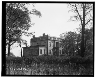
In 1811, the Hunter family built a beautiful house called a mansion. It was built in the English Georgian style. People said it was one of the best houses of its time. It had three stories, a big porch (called a veranda), and gardens that stepped down to the island's shore. The building was shaped like a rectangle. The main door faced west, towards the mainland. It had a grand doorway with columns. A covered entrance (a portico) at the back faced the Long Island Sound.
The mansion held a huge art collection with over 400 artworks. These included paintings by famous artists like Rembrandt, Peter Paul Rubens, and Leonardo da Vinci. The house was built on the highest point of the island, about 90 feet (27 meters) above sea level. From there, you could see Long Island Sound to the east. You could also see the hills and woods of the Town of Pelham to the north. When the mansion was there, most of the island was covered in lawns. There were also a few smaller buildings, like the old Old Stone House, a tenant's house, and a garden. The mansion was torn down in 1937 because it had become very old and damaged.
A stone causeway used to connect the island to the mainland. The entrance to the causeway from Eastern Boulevard (now Shore Road) had two white granite gateposts. The Hunter's Island Inn, a mansion owned by Elias Hunter's daughter, was across from these gateposts. The causeway blocked the flow of water in LeRoy's Bay. Parts of the bridge still exist today.
Hunter Island Wildlife Sanctuary
The Hunter Island Marine Zoology and Geology Sanctuary covers all of Twin Islands, Cat Briar Island, Two Trees Island, and the northeastern shore of Hunter Island. It has many glacial erratics. These are large boulders left behind by glaciers from the last glacial period. The rocky coast of Twin Islands has special rocks called Hartland schist. This rock is common on New England coastlines. It also has granite with both migmatite dikes and veins made of quartz.
This sanctuary is home to a unique ocean environment between the tides. This kind of environment is rare in New York State. It has the largest continuous oak forest in Pelham Bay Park. You can find white, red, and black oak trees here. Other trees include black cherry, white poplar, white pines, Norway spruce, and black locust trees. You can also find plants like grape hyacinth, periwinkle, daylily, and Tartarian honeysuckle. These were once part of the Hunter Mansion's garden. Animals living in the island's salt marsh include egrets, cormorants, fiddler crabs, horseshoe crabs, marine worms, barnacles, and oysters.
Kazimiroff Nature Trail
In 1983, people suggested creating the Theodore Kazimiroff Environmental Center. They also wanted a nature trail that would go through the park. It would be named after Theodore Kazimiroff, who had passed away in 1980. The Kazimiroff Nature Trail and the Pelham Bay Park Environmental Center at Orchard Beach opened in June 1986.
The Kazimiroff Nature Trail covers about 189 acres (76 hectares) of Hunter Island. Many of the island's natural features can be seen along the trail. The trail has two paths that overlap, called the "red" and "blue" trails. The blue trail is a bit longer than the red trail.
Along the shared part of the trail, you'll find a canal built to control mosquitoes. You'll also see where the old Hunter Island causeway's cobblestone path used to be. If you go counterclockwise from where the two loops meet, the trail passes through a group of 100 Norway spruce trees planted in 1918. Then, you'll see a black locust forest from the 1970s. Next is a thick area of shrubs and vines.
At this point, the longer blue trail turns northwest and then northeast. It passes the small hill where the Hunter Mansion used to be. You'll also see a forest of white pines, some mugwort, and invasive Ailanthus trees. The trail then goes by the Hunter Mansion's main driveway. You'll also see a less dense area of trees and burnt tree stumps. This was part of a forest burned by the Siwanoy people. Further along, there are white oaks and black locusts. You might also spot boulders covered in lichen, which is rare in New York City parks.
The shorter red trail goes directly north. It passes through a white poplar forest and an area burned by an uncontrolled fire. You can also see parts of the old stone walls from the former estates. Both trails then join and loop back to the east and south. Along this part, you'll see large glacial erratic boulders, New England bedrock, and the island's salt marsh. The "Gray Mare" glacial erratic can also be seen along this stretch of the trail.
