Hurricane Lee (2023) facts for kids

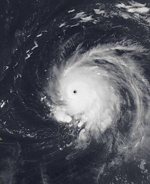
Lee at peak intensity to the east of the Leeward Islands on September 8
|
|
| Meteorological history | |
|---|---|
| Formed | September 5, 2023 |
| Extratropical | September 16, 2023 |
| Dissipated | September 19, 2023 |
| Category 5 tropical cyclone | |
| 1-minute sustained (SSHWS/NWS) | |
| Highest winds | 165 mph (270 km/h) |
| Lowest pressure | 926 mbar (hPa); 27.34 inHg |
| Overall effects | |
| Fatalities | 3 direct |
| Damage | $50 million (2023 USD) |
| Areas affected | Bermuda, Northeastern United States, Eastern Canada, United Kingdom |
|
Part of the 2023 Atlantic hurricane season |
|
Hurricane Lee was a very strong and long-lasting storm in September 2023. It started near West Africa and grew into a powerful Cape Verde hurricane. Lee affected places like Bermuda, the Northeastern United States, and Eastern Canada.
It was the thirteenth named storm of the 2023 Atlantic hurricane season. Lee became a Category 5 hurricane very quickly. Its winds increased by 75 mph (120 km/h) in just 24 hours! This made it one of the fastest-growing hurricanes ever recorded in the Atlantic. After being very strong, Lee weakened and changed its path. It eventually became an extratropical storm, meaning it lost its tropical features.
Even as it weakened, Lee brought heavy rain and strong winds. It caused power outages in Maine, New Brunswick, and Nova Scotia. Sadly, three people died because of the storm. Lee also created huge waves and dangerous rip currents along the U.S. Atlantic coast.
Lee's Journey and Strength
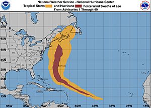
The National Hurricane Center (NHC) started watching a storm system near West Africa on September 1. This system moved over the Atlantic Ocean and slowly got more organized. By September 5, it had a clear center and became Tropical Depression Thirteen.
The conditions were perfect for the storm to grow stronger. The ocean water was warm, and there wasn't much wind blowing in different directions (called wind shear). Because of this, the depression quickly turned into Tropical Storm Lee. It then moved west-northwest, guided by a high-pressure system to its north.
Lee kept getting stronger. It developed rainbands and a clear "eye" in the middle. By September 6, it became a Category 1 hurricane. The next day, it grew incredibly fast. Lee reached Category 2 strength, then Category 4, and just a few hours later, it became a Category 5 hurricane. Special planes called "hurricane hunters" flew into the storm. They found a clear eye about 15 miles (24 km) wide.
By September 8, Lee's winds reached 145 mph (230 km/h). This amazing growth of 75 mph (120 km/h) in 24 hours made it the third-fastest strengthening Atlantic hurricane on record.
After its peak, Lee started to weaken. Winds blowing in different directions and changes in its inner structure (called eyewall replacement cycles) caused it to lose some strength. It became a Category 3 hurricane, then a Category 2. However, it later regained some strength, becoming a Category 3 again. Lee stayed a major hurricane for a few days, even as it went through more eyewall replacement cycles.
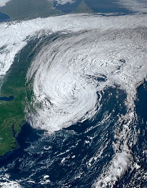
On September 13, Lee turned northward. It started moving over cooler water and faced stronger winds blowing in different directions. These conditions caused it to weaken again, becoming a Category 2, then a Category 1 hurricane. Its eye disappeared from satellite images. Lee passed close to Bermuda on September 14. As it moved north, it began to change into an extratropical storm. This change finished on September 16. The storm then made landfall in Nova Scotia, New Brunswick, and Prince Edward Island in Canada. Later, as an extratropical low, Lee brought rain and strong winds to parts of the United Kingdom and Ireland.
How People Prepared and What Happened
People in the path of Hurricane Lee took many steps to stay safe. Governments issued warnings, and emergency teams got ready.
Bermuda's Experience
Bermuda received tropical storm warnings on September 13. The island experienced tropical storm conditions. The local government moved its meeting date. The airport closed until September 16. Over 11,000 people lost power. Bus depots also had power failures and closed. Some damage occurred at the Royal Naval Dockyard, causing ferry delays.
United States Prepares
Hurricane and tropical storm watches were issued for the New England coast. This included areas from Rhode Island to Maine. Dangerous waves and rip currents were a problem along the entire U.S. East Coast. Flights were canceled or delayed at many airports.
New York's Actions
New York's Governor sent 50 National Guard members to Long Island. They were there to help if needed. Coastal towns like Southampton and East Hampton declared emergencies. They closed coastal roads and banned swimming at beaches. Eastern Long Island saw some beach erosion and strong winds.
Massachusetts' Response
In Massachusetts, people moved boats to safe harbors. Ferry services to islands like Martha's Vineyard and Nantucket were canceled. Boston's Mayor opened an emergency center. They prepared sandbags and flood walls. The police and fire departments were on standby. The Governor declared a state of emergency. She activated 50 National Guard members to help with rescues. Many flights at Logan International Airport were canceled. Most damage was from trees falling due to strong winds and wet ground. In Cohasset, a police car was crushed by a falling tree.
Rhode Island's Preparations
The Rhode Island Department of Transportation cleaned storm drains and cut down risky trees. This helped prevent flooding and wind damage. State officials held a press conference to remind people to prepare. They also took down the "Independent Man" statue from the Rhode Island State House for repairs.
New Hampshire's Warnings
New Hampshire's Governor warned residents to be ready. Utility crews were placed around the state to quickly fix power outages. A wind advisory was issued for the White Mountains. Winds there reached up to 96 mph (154 km/h) on Mount Washington.
Maine's Impact

Maine's Governor declared a state of emergency. She asked the President for a disaster declaration, which he approved. Utility workers from other states came to help. Boat owners were told to secure their boats. Many flights at Portland and Bangor airports were canceled. Acadia National Park closed some areas.
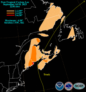
On September 16, strong winds caused damage in southeastern Maine. Trees fell, blocking roads. Over 92,000 homes lost power. Two people were rescued after their boat overturned near Winter Harbor. Sadly, one person died in Searsport when a tree fell on their car. Another person was injured by a falling tree. In Bar Harbor, a whale watching boat broke free and crashed ashore. Fuel had to be removed to prevent a spill. Heavy rain also fell, with 6.5 inches (165 mm) recorded in Steuben.
Canada's Response
Environment Canada issued hurricane watches for parts of New Brunswick and Nova Scotia. Tropical storm watches were also issued. Prime Minister Justin Trudeau met with officials to discuss the storm. He urged Canadians to take precautions.
Strong winds caused widespread but minor damage in Nova Scotia and New Brunswick. This was mostly fallen trees and power lines. About 140,000 homes in Nova Scotia and 37,000 in New Brunswick lost power.
New Brunswick's Actions
Cruise ship stops at the Port of Saint John were canceled. Officials warned of dangerous driving conditions and told residents to stay home. Power crews were ready to respond. Many flights were canceled at airports in Moncton and Fredericton. Ferry service to Grand Manan was stopped. Trees fell, sometimes taking utility poles with them. Low-lying areas in Saint John and Fredericton had some flooding. Several old trees in Saint John were knocked over.
Nova Scotia's Experience
Officials held a press conference to warn people to finish preparations. Utility crews were ready across the province. Ferry sailings were canceled. Most flights at Halifax Stanfield International Airport were canceled. Over 200,000 customers lost electricity. A utility pole caught fire. Coastal roads were flooded by storm surge, and some were destroyed. Most damage was from trees falling due to wind. Rissers Beach Provincial Park had significant storm surge damage. The highest wind gust in Canada, 73 mph (117 km/h), was recorded at Halifax airport.
Prince Edward Island's Preparations
Ferry crossings between Nova Scotia and Prince Edward Island were canceled. Utility crews were ready for power outages. Flights to and from Charlottetown Airport were also canceled.
Elsewhere Affected
A tropical cyclone alert was in effect for the Leeward Islands and the British Virgin Islands. High surf warnings were also issued.
The U.S. government sent food, water, and response teams to Puerto Rico and the United States Virgin Islands. They also issued high surf warnings for these areas.
The Met Office in the UK issued flood warnings for parts of Northern England and Wales as Lee's remnants arrived.
See also
 In Spanish: Huracán Lee (2023) para niños
- Weather of 2023
- Tropical cyclones in 2023
- Timeline of the 2023 Atlantic hurricane season
- List of Category 5 Atlantic hurricanes
- List of hurricanes in Canada
- 1940 Nova Scotia hurricane – a Category 2 hurricane that followed a similar track and affected similar areas
- Hurricane Carol (1953) – a Category 5 hurricane that followed a similar track and made landfall in New Brunswick
- Hurricane Edouard (1996) – a Category 4 hurricane that followed a similar track, but turned northeastward missing Nova Scotia
- Hurricane Earl (2010) – a Category 4 that followed a similar track and made landfall in Nova Scotia
 | Lonnie Johnson |
 | Granville Woods |
 | Lewis Howard Latimer |
 | James West |


