International Falls, Minnesota facts for kids
Quick facts for kids
International Falls
|
|
|---|---|

International Falls
|
|
| Nickname(s):
Icebox of the Nation,
Frostbite Falls |
|

|
|
| Country | United States |
| State | Minnesota |
| County | Koochiching |
| Founded | 1870 |
| Area | |
| • Total | 6.42 sq mi (16.63 km2) |
| • Land | 6.41 sq mi (16.60 km2) |
| • Water | 0.01 sq mi (0.03 km2) |
| Elevation | 1,131 ft (345 m) |
| Population
(2020)
|
|
| • Total | 5,802 |
| • Estimate
(2023)
|
5,603 |
| • Density | 905.29/sq mi (349.55/km2) |
| Time zone | UTC-6 (Central) |
| • Summer (DST) | UTC-5 (-CDT) |
| ZIP code |
56649, 56679
|
| Area code | 218 |
| FIPS code | 27-31040 |
| GNIS feature ID | 0645435 |
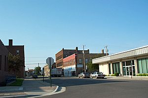
International Falls (also called I-Falls) is a city in Minnesota, United States. It is the main city and county seat of Koochiching County. In 2020, about 5,802 people lived there.
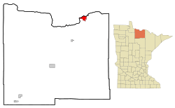
This city is located on the Rainy River. This river forms the border between the United States and Canada. Right across the river is Fort Frances, a town in Ontario, Canada. The two places are connected by an international bridge.
Just 11 miles east of International Falls is Voyageurs National Park. This park is known for its beautiful lakes and forests. The city is also a major entry point between the U.S. and Canada. There are customs offices on both sides of the bridge.
International Falls is famous for its cold weather. It is nicknamed the "Icebox of the Nation." On average, the temperature stays below freezing for over 100 days each year!
Contents
History of International Falls
Early Days and Naming the Town
The area where International Falls now stands was once home to many indigenous peoples. Explorers and missionaries knew about this area as early as the 1600s.
In April 1895, a community was planned and laid out by L. A. Ogaard. It was first named Koochiching. This name comes from Native American words meaning "at the place of inlets." This refers to the nearby Rainy Lake and River. European settlers called these waters "Rainy" because of the mist that looked like rain near the falls.
On August 10, 1901, Koochiching officially became a village. Two years later, its name was changed to International Falls. This new name recognized the river's role as a border between the U.S. and Canada. In 1909, it became a city.
Growth of Industry and Business
A businessman named E.W. Backus saw that the Rainy River had great potential for water power. In the early 1900s, he built a dam on the river. This dam helped power his company's paper mills.
Later, in 1965, the company was bought by Boise Cascade Corporation. Even after being sold to another group in 2003, this company remained the biggest employer in the area. In 2013, Boise laid off many workers and closed a paper machine. The company was then sold to Packaging Corporation of America (PCA).
Geography and Climate
Where is International Falls Located?
International Falls covers an area of about 6.53 square miles (16.9 square kilometers). Most of this area is land, with a small part being water.
What is the Climate Like?
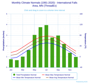
International Falls has a warm-summer humid continental climate. This means it has very long, cold winters and warm, humid summers.
In January, the average temperature is about 5 degrees Fahrenheit (minus 15 degrees Celsius). Temperatures often stay below freezing for weeks in winter. The city gets a lot of snow, averaging about 73 inches (185 cm) per year.
Summers are warm, with July averaging about 65 degrees Fahrenheit (18 degrees Celsius). Temperatures rarely reach 90 degrees Fahrenheit (32 degrees Celsius). The city gets most of its rain in the warmer months.
| Climate data for International Falls, Minnesota (Falls International Airport), 1991–2020 normals, extremes 1897–present | |||||||||||||
|---|---|---|---|---|---|---|---|---|---|---|---|---|---|
| Month | Jan | Feb | Mar | Apr | May | Jun | Jul | Aug | Sep | Oct | Nov | Dec | Year |
| Record high °F (°C) | 53 (12) |
58 (14) |
79 (26) |
93 (34) |
95 (35) |
101 (38) |
103 (39) |
96 (36) |
96 (36) |
88 (31) |
74 (23) |
56 (13) |
103 (39) |
| Mean maximum °F (°C) | 38.5 (3.6) |
42.9 (6.1) |
56.1 (13.4) |
72.5 (22.5) |
83.7 (28.7) |
86.7 (30.4) |
88.7 (31.5) |
87.4 (30.8) |
83.6 (28.7) |
74.0 (23.3) |
54.7 (12.6) |
39.7 (4.3) |
90.7 (32.6) |
| Mean daily maximum °F (°C) | 15.7 (−9.1) |
21.7 (−5.7) |
35.4 (1.9) |
50.1 (10.1) |
64.2 (17.9) |
73.5 (23.1) |
77.7 (25.4) |
76.0 (24.4) |
66.4 (19.1) |
51.2 (10.7) |
34.4 (1.3) |
20.8 (−6.2) |
48.9 (9.4) |
| Daily mean °F (°C) | 5.0 (−15.0) |
9.5 (−12.5) |
23.6 (−4.7) |
38.1 (3.4) |
51.1 (10.6) |
60.8 (16.0) |
64.9 (18.3) |
62.8 (17.1) |
54.2 (12.3) |
41.1 (5.1) |
26.3 (−3.2) |
11.8 (−11.2) |
37.4 (3.0) |
| Mean daily minimum °F (°C) | −5.8 (−21.0) |
−2.6 (−19.2) |
11.8 (−11.2) |
26.1 (−3.3) |
38.1 (3.4) |
48.2 (9.0) |
52.0 (11.1) |
49.7 (9.8) |
42.0 (5.6) |
31.1 (−0.5) |
18.1 (−7.7) |
2.7 (−16.3) |
26.0 (−3.3) |
| Mean minimum °F (°C) | −33.0 (−36.1) |
−28.7 (−33.7) |
−16.4 (−26.9) |
10.7 (−11.8) |
24.4 (−4.2) |
33.4 (0.8) |
40.1 (4.5) |
37.0 (2.8) |
26.8 (−2.9) |
16.9 (−8.4) |
−3.2 (−19.6) |
−25.2 (−31.8) |
−36.2 (−37.9) |
| Record low °F (°C) | −55 (−48) |
−48 (−44) |
−38 (−39) |
−14 (−26) |
8 (−13) |
23 (−5) |
32 (0) |
27 (−3) |
19 (−7) |
2 (−17) |
−32 (−36) |
−41 (−41) |
−55 (−48) |
| Average precipitation inches (mm) | 0.79 (20) |
0.69 (18) |
1.02 (26) |
1.64 (42) |
3.06 (78) |
3.78 (96) |
3.97 (101) |
2.82 (72) |
3.00 (76) |
2.22 (56) |
1.39 (35) |
0.99 (25) |
25.37 (644) |
| Average snowfall inches (cm) | 15.7 (40) |
12.6 (32) |
7.9 (20) |
7.0 (18) |
0.2 (0.51) |
0.0 (0.0) |
0.0 (0.0) |
0.0 (0.0) |
0.1 (0.25) |
1.6 (4.1) |
12.1 (31) |
15.8 (40) |
73.0 (185) |
| Average precipitation days (≥ 0.01 in) | 10.1 | 9.0 | 8.3 | 9.4 | 12.7 | 13.8 | 12.5 | 11.0 | 12.2 | 12.6 | 10.2 | 11.1 | 132.9 |
| Average snowy days (≥ 0.1 in) | 13.6 | 11.4 | 6.9 | 4.0 | 0.4 | 0.0 | 0.0 | 0.0 | 0.1 | 2.5 | 10.0 | 12.5 | 61.4 |
| Average relative humidity (%) | 70.8 | 67.4 | 65.7 | 61.1 | 61.3 | 68.6 | 71.2 | 74.8 | 77.1 | 74.2 | 78.8 | 77.1 | 70.7 |
| Average dew point °F (°C) | −5.4 (−20.8) |
−0.2 (−17.9) |
12.6 (−10.8) |
25.2 (−3.8) |
37.6 (3.1) |
49.6 (9.8) |
56.1 (13.4) |
54.3 (12.4) |
45.3 (7.4) |
33.8 (1.0) |
19.2 (−7.1) |
2.5 (−16.4) |
27.6 (−2.5) |
| Source: NOAA (relative humidity 1961–1990) | |||||||||||||
Why is it Called the "Icebox of the Nation"?
International Falls has proudly called itself the "Icebox of the Nation" for a long time. Another town, Fraser, Colorado, also claimed this slogan.
The two towns argued over who had the right to use the phrase. In 1986, International Falls paid Fraser $2,000 to give up its claim. However, in 1996, International Falls accidentally forgot to renew its federal trademark. Fraser then tried to get the trademark for itself.
International Falls showed old photos from 1955 of its hockey team using the slogan. After several years, the U.S. Patent and Trademark Office officially gave the trademark to International Falls in 2008. Just days after winning the trademark, International Falls set a new record for its coldest daily temperature!
Population and People
How Many People Live Here?
| Historical population | |||
|---|---|---|---|
| Census | Pop. | %± | |
| 1910 | 1,487 | — | |
| 1920 | 3,448 | 131.9% | |
| 1930 | 5,036 | 46.1% | |
| 1940 | 5,626 | 11.7% | |
| 1950 | 6,269 | 11.4% | |
| 1960 | 6,778 | 8.1% | |
| 1970 | 6,439 | −5.0% | |
| 1980 | 5,611 | −12.9% | |
| 1990 | 8,324 | 48.4% | |
| 2000 | 6,703 | −19.5% | |
| 2010 | 6,424 | −4.2% | |
| 2020 | 5,802 | −9.7% | |
| 2022 (est.) | 5,665 | −11.8% | |
| U.S. Decennial Census 2020 Census |
|||
In 2010, there were 6,424 people living in International Falls. There were 2,903 households, which are groups of people living together.
Most of the people in the city were White (93.3%). There were also Native American (2.5%) and African American (1.0%) residents. About 1.1% of the population was Hispanic or Latino.
The average age of people in the city was 42.4 years old. About 21.9% of residents were under 18 years old.
Local Media and News
Radio Stations
| Frequency | Call sign | Name | Format | Owner |
|---|---|---|---|---|
| 88.3 88.3 HD-2 |
KITF | MPR News Classical MPR |
NPR Classical |
Minnesota Public Radio |
| 91.9 | KXBR | The Bridge | Christian | Heartland Christian Broadcasters, Inc. |
| 95.3 | W237EX (KGHS-AM Translator) |
Oldies | R & J Broadcasting | |
| 97.7 | K249BK (KITF HD-2 Translator) |
Classical MPR | Classical | Minnesota Public Radio |
| 99.5 | KBHW | Psalm 99:5 | Christian | Heartland Christian Broadcasters, Inc. |
| 104.1 | KSDM | K-104 | Country | R & J Broadcasting |
The Icebox Radio Theater in International Falls creates radio drama shows. You can listen to them on 106.9 FM.
| Frequency | Call sign | Name | Format | Owner |
|---|---|---|---|---|
| 1230 | KGHS | Oldies | R & J Broadcasting |
Television Channels
| Channel | Callsign | Affiliation | Branding | Subchannels | Owner | |
|---|---|---|---|---|---|---|
| (Virtual) | Channel | Programming | ||||
| 9.1 | K18MB-D (KAWE Translator) |
PBS | Lakeland PBS | 9.2 9.3 9.4 9.5 9.6 |
First Nations Experience PBS Kids Create PBS Encore Minnesota Channel |
County of Koochiching |
| 11.1 | K22MZ-D (KRII Translator) |
NBC | KBJR 6 | 11.2 11.3 |
CBS H&I/MyNetworkTV |
County of Koochiching |
| 13.1 | K24MT-D (WIRT Translator) |
ABC | 13.2 13.3 |
MeTV Ion Television |
County of Koochiching | |
| 21.1 | K20NR-D (KQDS Translator) |
Fox | FOX 21 | 21.2 | Antenna TV | Red River Broadcasting |
| 39.1 | K38MM-D | 3ABN | 39.2 39.3 39.4 39.5 39.6 39.7 |
3ABN Proclaim 3ABN Dare to Dream 3ABN Latino 3ABN Radio 3ABN Radio Latino Radio 74 |
Edge Spectrum, Inc. | |
Local cable TV is provided by Midcontinent Communications.
Newspapers in International Falls
The local newspaper, The Journal, closed on June 24, 2021, after being published since 1911.
A new newspaper, the Rainy Lake Gazette, started on July 16, 2021. It is published by CherryRoad Media Inc.. You can find it online at rainylakegazette.com.
Culture and Arts
International Falls has a lively cultural scene.
- The Icebox Radio Theater is a local group that produces radio dramas.
The Backus Community Center opened in 2002. It is a hub for cultural events in the city. Each year, the Backus Performing Arts Series hosts many music and theater shows.
The Borealis Bards is a community theater group. They have put on several plays since 2014, including Alice In Wonderland in 2015.
The International Falls post office has a special mural. It is called Early Lodging in Koochichin Falls. The mural was painted by Lucia Wiley. Many murals like this were created across the U.S. in the 1930s and 1940s. They were part of government programs to support artists during tough economic times.
Transportation and Travel
Air and Rail Travel
Falls International Airport (airport code: INL) is just south of the city. It has two runways. The airport is mostly used for private planes. However, Delta Air Lines also has daily flights to Minneapolis–Saint Paul International Airport.
The Minnesota, Dakota and Western Railway operates a 4-mile (6 km) train line. This line runs between International Falls and Ranier.
Major Roads and Highways
Several important roads pass through International Falls:
The city's port code is 3604.
Famous People from International Falls
Many notable people have connections to International Falls:
- Edward Backus – An important industrialist.
- Tammy Bakker – A well-known television personality.
- Dean Blais – A successful hockey coach.
- Bill Borcher – A former head basketball coach for the University of Oregon.
- Keith Christiansen – A hockey player and Olympic silver medalist.
- Kevin Constantine – A hockey coach in the NHL.
- Jim Crotty – A professional football player for the Washington Redskins.
- Mike Curran – A hockey player and Olympic silver medalist.
- Richard Dougherty – A hockey player and Olympic silver medalist.
- Constance Edith Fowler – An artist, printmaker, author, and educator.
- Arlys Johnson-Maxwell – A Senior World Champion weightlifter in 1987.
- Bob Mason – An NHL goalie and coach for the Minnesota Wild.
- Jack McDonald – An ice hockey goaltender for Michigan.
- Bronko Nagurski – A famous football player in both college and professional halls of fame.
- Bronko Nagurski Jr. – A football player for Notre Dame and in the Canadian Football League.
- Bob Neuenschwander – A Minnesota state legislator and businessman.
- Ernest Oberholtzer – An explorer, author, and conservationist.
- Gary Sampson – A hockey player for the Washington Capitals.
- Neil Sheehy – A hockey player and NHL agent.
- Timothy Sheehy – A hockey player and Olympic silver medalist.
- Frank Youso – An NFL player for teams like the New York Giants.
- Larry Ross – A high school hockey coach who won 6 state championships.
See also
 In Spanish: International Falls (Minnesota) para niños


