Jackson County, Arkansas facts for kids
Quick facts for kids
Jackson County
|
|
|---|---|

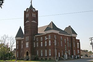
Jackson County Courthouse
|
|

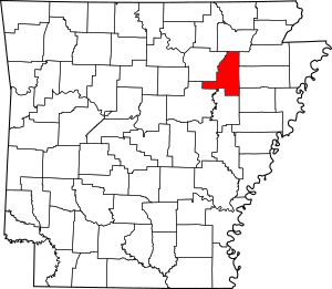
Location within the U.S. state of Arkansas
|
|
 Arkansas's location within the U.S. |
|
| Country | |
| State | |
| Founded | November 5, 1829 |
| Named for | Andrew Jackson |
| Seat | Newport |
| Largest city | Newport |
| Area | |
| • Total | 642 sq mi (1,660 km2) |
| • Land | 634 sq mi (1,640 km2) |
| • Water | 7.6 sq mi (20 km2) 1.2%% |
| Population
(2020)
|
|
| • Total | 16,755 |
| • Estimate
(2023)
|
16,784 |
| • Density | 26.098/sq mi (10.077/km2) |
| Time zone | UTC−6 (Central) |
| • Summer (DST) | UTC−5 (CDT) |
| Congressional district | 1st |
Jackson County is a place in the Arkansas Delta region of Arkansas, a state in the United States. This county got its name from Andrew Jackson. He was a national hero during the War of 1812. By the time Jackson County was formed in 1829, Andrew Jackson had become the seventh President of the United States.
Jackson County is home to seven towns and four cities. Newport is the largest city and also where the county government is located. The county also has many small, unnamed communities and even some ghost towns. Jackson County covers about 634 square miles (1,642 square kilometers). This makes it the 41st largest county out of 75 in Arkansas.
In 2020, about 16,755 people lived here. This makes it the 44th largest county by population in Arkansas. Most of Jackson County is flat land with rich soil. This area is part of the Arkansas Delta. Historically, it had many forests, bayous, and swamps. Early settlers cleared the land for farming. The White River flows through and drains the county.
Jackson County does not have any major Interstate highways. However, two U.S. highways (U.S. Route 67 and U.S. Route 167) and fifteen Arkansas state highways cross the county. A Union Pacific Railroad train line also runs through the area.
Contents
Exploring Jackson County's Geography
Jackson County covers a total area of about 642 square miles (1,663 square kilometers). Most of this area, about 634 square miles (1,642 square kilometers), is land. The remaining 7.6 square miles (20 square kilometers) is water.
Main Roads and Highways
 Future Interstate 57
 U.S. Highway 67
 U.S. Highway 167
 Highway 14
 Highway 17
 Highway 18
 Highway 18 Spur
 Highway 33
 Highway 37
 Highway 42
 Highway 69
 Highway 69 Spur
 Highway 87
 Highway 145
 Highway 157
 Highway 224
 Highway 226
 Highway 367
 Highway 384
 Airport Highway 980
Neighboring Counties
Jackson County shares its borders with several other counties:
- Lawrence County (to the north)
- Craighead County (to the northeast)
- Poinsett County (to the east)
- Cross County (to the southeast)
- Woodruff County (to the south)
- White County (to the southwest)
- Independence County (to the west)
Special Protected Areas
Part of the Cache River National Wildlife Refuge is located within Jackson County. This refuge helps protect important natural habitats.
Who Lives in Jackson County?
| Historical population | |||
|---|---|---|---|
| Census | Pop. | %± | |
| 1830 | 333 | — | |
| 1840 | 1,540 | 362.5% | |
| 1850 | 3,086 | 100.4% | |
| 1860 | 10,493 | 240.0% | |
| 1870 | 7,268 | −30.7% | |
| 1880 | 10,877 | 49.7% | |
| 1890 | 15,179 | 39.6% | |
| 1900 | 18,383 | 21.1% | |
| 1910 | 23,501 | 27.8% | |
| 1920 | 25,446 | 8.3% | |
| 1930 | 27,943 | 9.8% | |
| 1940 | 26,427 | −5.4% | |
| 1950 | 25,912 | −1.9% | |
| 1960 | 22,843 | −11.8% | |
| 1970 | 20,452 | −10.5% | |
| 1980 | 21,646 | 5.8% | |
| 1990 | 18,944 | −12.5% | |
| 2000 | 18,418 | −2.8% | |
| 2010 | 17,997 | −2.3% | |
| 2020 | 16,755 | −6.9% | |
| 2023 (est.) | 16,784 | −6.7% | |
| U.S. Decennial Census 1790–1960 1900–1990 1990–2000 2010 |
|||
Snapshot: The 2020 Census
The 2020 United States census counted 16,755 people living in Jackson County. There were 6,137 households and 3,758 families. Most residents, about 76%, identified as White. About 16.5% identified as Black or African American. Other groups made up smaller percentages of the population.
Towns and Cities in Jackson County
Main Cities
- Campbell Station
- Diaz
- Grubbs
- Newport (This is the county seat, where the main county offices are)
- Swifton
- Tuckerman
Smaller Towns
Other Small Communities
These are smaller places that are not officially incorporated as cities or towns:
- Balch
- Centerville
- Denmark
- Heffington
- Kenyon
- Macks
- Midway
- Olyphant
- Possum Grape
Ghost Towns: Places of the Past
These are towns that no longer exist or are mostly abandoned:
- Colerain
- Estico
- Mt. Pinson
- Myrickville
- Sneed
How the County is Divided: Townships
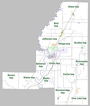
Jackson County is divided into smaller areas called townships. Here are the townships: Townships in Arkansas are the divisions of a county. Each township includes unincorporated areas; some may have incorporated cities or towns within part of their boundaries. Arkansas townships have limited purposes in modern times. However, the United States Census does list Arkansas population based on townships (sometimes referred to as "county subdivisions" or "minor civil divisions"). Townships are also of value for historical purposes in terms of genealogical research. Each town or city is within one or more townships in an Arkansas county based on census maps and publications. The townships of Jackson County are listed below; listed in parentheses are the cities, towns, and/or census-designated places that are fully or partially inside the township.
- Barren
- Bateman (includes part of Newport)
- Bird (includes most of Tuckerman)
- Breckinridge (includes Tupelo and Weldon)
- Bryan
- Cache
- Cow Lake (includes Beedeville)
- Glaize
- Glass (includes Swifton)
- Grubbs (includes Grubbs)
- Jefferson (includes Campbell Station and Jacksonport, part of Diaz and Tuckerman)
- Richwoods (includes Amagon)
- Union (includes most of Diaz and Newport)
- Village (includes part of Diaz and Newport)
See also
 In Spanish: Condado de Jackson (Arkansas) para niños


